The 2019 Esri User Conference is almost here! Here are some quick tips to get the most out of all things imagery and remote sensing this year (more details below).
- Learn more about this year’s preconference seminars for imagery.
- Check out the agenda for Imagery Summit @ Esri UC (There’s still time to register!).
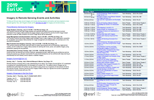
- Download the Imagery and Remote Sensing events flyer, check the online imagery agenda, and download the Esri Events app to plan out the imagery sessions you want to attend.
- Come see us at the Imagery Showcase in the Esri Expo!

Preconference seminars for imagery
Preconference seminars focusing on the imagery and remote sensing capabilities of ArcGIS will take place the Saturday and Sunday before UC. There’s still time to register; either sign up when you register for the UC, or add seminars afterward by calling 1-888-377-4576 between 9:00 a.m. – 4:00 p.m. (PST).
Image Analysis | Saturday, July 6, 8:30 AM – 5:00 PM
This hands-on seminar will help image analysts and scientists who want to know the best way to extract information from imagery. Best practices for image analysis using ArcGIS Pro and the ArcGIS Image Analyst extension as well as raster analytics via ArcGIS Image Server will be addressed.
Image Management and Dissemination | Saturday, July 6, 8:30 AM – 5:00 PM
This hands-on seminar will show imagery asset managers how to make imagery in their organization accessible for visualization and analysis. Best practices for image management and dissemination on premises and in the cloud will be explained.
Map Production from Imagery | Saturday, July 6, 8:30 AM – 5:00 PM
This hands-on seminar will assist users who want to create map products such as orthophotos, digital terrain models, and 3D models from imagery. Best practices for working with drone, aerial, and satellite imagery using orthophoto mapping will be presented.
Geospatial Deep Learning | Sunday, July 7, 8:30 AM – 5:00 PM
Nvidia and Esri are teaming up to bring a hands-on, geospatial-focused, deep learning preconference seminar. During this seminar you will learn how ArcGIS Pro and ArcGIS Enterprise can be combined with deep learning to automatically find and classify various objects in satellite imagery.
Imagery Summit @ Esri UC
The Imagery Summit @ Esri UC, taking place Sunday, July 7 – Tuesday, July 9, is dedicated to enabling this understanding within the framework of a modern GIS. The speed at which changes can be identified and authoritative 3D content can be created is being driven by an explosion of new sensors all tied to the internet of things. Discover how the ArcGIS Imagery Platform helps you harness this tsunami of geospatial information to drive success with your GIS. There’s still time to register.
2019 Esri UC imagery sessions
There are over fifty sessions devoted to imagery and remote sensing this year, so take some time to explore your options ahead of time. Download the Imagery and Remote Sensing Events flyer to see a comprehensive list of imagery tech sessions and demo theaters. Plus, check out the online UC 2019 imagery agenda and download the Esri Events app to scout out sessions and save the imagery and remote sensing sessions you plan to attend.
Imagery Showcase in the Esri Expo
We are gearing up to nerd out about imagery and remote sensing—we can’t wait to talk to you. Have questions about managing imagery in the cloud? Wondering if object detection using deep learning could help out your organization? Still not sure what a mosaic dataset is? That’s what we’re here for. We’ll be in Exhibit hall B. Find some time between sessions to come talk to us about your work and learn the latest about imagery and remote sensing in ArcGIS.
Expo hours are:
Tuesday, July 9, 9:00 AM–6:00 PM
Wednesday, July 10, 9:00 AM–6:00 PM
Thursday, July 11, 9:00 AM–4:00 PM

Commenting is not enabled for this article.