For Autodesk users, Esri offers ArcGIS which is a suite of powerful tools that seamlessly blend geospatial data with design and construction processes. In this blog, we’ll highlight the capabilities that support Civil Engineers, CAD Technicians, and Project Managers, highlighting how ArcGIS can enhance your projects and streamline your operations.
Streamline your project data and workflows
As a CAD user, you’re aware that creating precise and contextually accurate designs is crucial for successful projects. To achieve this, you need more than just design tools—you need access to reliable geospatial data and the ability to perform advanced spatial analysis. You need to incorporate real-world context into your designs to help you make informed decisions, enhance project visualizations, and ultimately deliver more comprehensive and impactful work. This integration of geospatial insights is not just an advantage; it’s a necessity for modern design workflows.

This is where ArcGIS for AutoCAD comes in, offering seamless integration of GIS data directly within your familiar design environment, giving you effortless data synchronization and powerful spatial analysis capabilities. The plug-in brings ArcGIS to AutoCAD and Civil 3D to enrich existing CAD workflows with authoritative GIS content, greatly increasing the effectiveness of CAD-GIS interoperability and saving time and effort in quality control. This enables other departments across the organization, including field staff, to work with the same data synchronously, eliminating prior communication gaps. Designers can view GIS layers and contextualize their drawings, contributing to a system of record in collaboration with their project teams.
Collaboratively edit and synchronize project data
ArcGIS for AutoCAD deepens collaborations between CAD and GIS teams, for example, by supporting multiuser editing workflows. With branch versioning, CAD professionals can operate on the same project data at the same time as their CAD teammates. All team members make edits and synchronize changes, in the usual way, from within their CAD environment.
Streamlined symbolization and labeling
ArcGIS for AutoCAD links GIS attributes to your CAD entities, allowing you to eliminate the tedium of symbolizing and labeling your drawings. Generate CAD labels from GIS Attributes. Symbolize point features as Block Inserts, COGO or AutoCAD points. And it’s all dynamic. Any changes you make to the linked CAD entities update the GIS, and any changes you make to the GIS attribute values update the CAD.

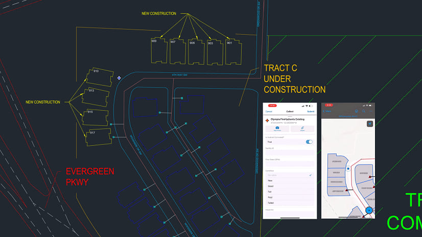
Collaborate on asset location and condition
While working in AutoCAD and Civil 3D with ArcGIS for AutoCAD, CAD technicians and Civil engineers can collaborate with field and GIS professionals, while using their familiar software and workflows and operating on the same data. Asset statuses and locations can be confirmed in the field, and synced to the CAD drawing as feature layers, including attachments such as a picture confirming the status and location of the asset.
Integrating CAD and GIS workflows for smarter indoor spaces
As a CAD user venturing into the realm of indoor GIS, you know that designing and managing indoor spaces requires more than just precise drawings. You need a comprehensive understanding of the spatial context, including how people and assets interact within those spaces.
This involves accurate 3D modeling of interiors, seamless integration of real-world data, and advanced spatial analysis tools. The ability to visualize and analyze indoor environments can significantly enhance your design processes, improve facility management, and support better decision-making. To create efficient, safe, and user-friendly indoor spaces, ArcGIS Indoors for AutoCAD is essential.

Importing and converting CAD Data
ArcGIS Indoors allows you to import your AutoCAD, Revit, and IFC files, converting detailed design data into interactive indoor maps. By doing so, you extend the usefulness of your building data beyond the design phase and into day-to-day operations.
These indoor maps become invaluable tools for a multitude of tasks, from asset and space management to enhancing safety, security, and the overall occupant experience. ArcGIS Indoors for AutoCAD ensures that your floorplan data is optimally prepared for a seamless transition, enabling you to leverage the full power of GIS within your indoor environments.
Ensuring data compatibility
Integrating ArcGIS Indoors for AutoCAD into your data workflows is crucial for Autodesk users because CAD floor plans, while detailed, aren’t inherently designed for indoor GIS purposes. Architectural, engineering, and construction (AEC) drawings often don’t align perfectly with the needs of indoor GIS, which requires an accurate representation of spaces to support use cases such as space planning and management, asset inspections, location sharing, and wayfinding.
By using ArcGIS Indoors for AutoCAD, you ensure that all lines, blocks, text, and other objects in your CAD drawings are accurately positioned and translated into meaningful GIS features. This not only bridges the gap between design and operational data but also empowers you to harness the full spectrum of indoor GIS capabilities, making your indoor spaces smarter and more efficient.

Streamlining data sharing
Sharing data between CAD and GIS platforms is streamlined with ArcGIS Indoors for AutoCAD. When preparing to transfer CAD floor plan data to a GIS, this tool helps you assess and verify the readiness of your CAD data. It generates comprehensive reports that guide you in making necessary adjustments using your existing CAD tools, ensuring your data meets your CAD standards.
Conversely, when sharing GIS data to CAD, ArcGIS Indoors for AutoCAD helps establish a baseline for data quality. This baseline serves as a benchmark to maintain quality throughout the design and construction phases, ensuring that the final as-built floor plan drawings are GIS-ready with minimal additional preparation. This bidirectional capability not only saves time but also enhances the accuracy and usability of your data across both platforms.
Unifying construction data: Seamless integration for better project outcomes
As a Project Manager in today’s fast-evolving construction industry, effectively managing and integrating data from various sources is more crucial than ever. With the increasing adoption of Building Information Modeling (BIM), CAD, and GIS, Project Managers face the challenge of leveraging these technologies to optimize workflows and enhance collaboration.
Bridging the gap between BIM, CAD, and GIS
The solution to this challenge lies in ArcGIS GeoBIM—a powerful cloud-to-cloud application that bridges the gap between BIM, CAD, and GIS by connecting directly to Autodesk Construction Cloud. By harnessing the capabilities of ArcGIS GeoBIM, Project Managers can seamlessly integrate and manage data throughout the project lifecycle, from initial planning and design to construction and facility management. This not only improves overall project outcomes but also ensures that all stakeholders are working from a single, authoritative source of truth.

Enhancing collaboration with web-based tools
ArcGIS GeoBIM delivers an innovative, web-based experience for teams to collaborate on BIM projects and issues in geospatial context. AEC and operations teams can work with linked data and documentation from multiple systems, including Autodesk Construction Cloud and Autodesk BIM 360, and configure web apps for streamlining communication and collaboration.

Streamlining data access and decision-making
With ArcGIS GeoBIM, teams spend less time on costly and time-consuming file conversion improving access to reliable, up-to-date project and asset data, including 3D BIM models, reality capture, field maps, documentation, and issues. As a result, teams can see active information that helps them make better decisions and facilitate collaboration for improved project outcomes.
Lastly, ArcGIS GeoBIM helps to extend the value of BIM throughout the infrastructure life cycle. By using ArcGIS GeoBIM for digital project handovers into operations and maintenance, you can enable owners and operators to easily find and access information, reusing it for planning capital improvements or improving efficiency. Offering a unified view of projects and assets helps to improve operations, reduce costs, and mitigate environmental impacts.

Closing thoughts
By integrating ArcGIS with Autodesk products, you gain access to a comprehensive suite of tools designed to enhance your BIM/CAD workflows. From seamless data integration and sophisticated spatial analysis to detailed indoor mapping and effective lifecycle management, ArcGIS provides the tools you need to elevate your projects and streamline your operations. Leverage these powerful integrations to achieve greater efficiency and help your firm and projects stand out.
Get started
Get started with ArcGIS for CAD and BIM today. To learn more about how ArcGIS can support your Autodesk workflows, explore our resources for further learning, including webinars, tutorials, and documentation. We also invite you to connect with your Esri representative, where you can discuss your project and how these tools can benefit your workflows. Don’t miss the opportunity to try out ArcGIS products.


Commenting is not enabled for this article.