ArcGIS StoryMaps is the professional storytelling tool that enables you to transform your geographic work into interactive content to inform and inspire others. It makes it easy to explain complex topics related to your knowledge and experience. ArcGIS StoryMaps is updated regularly with new features and capabilities, and here’s what’s been added recently:
- Undo/Redo
- Image editor
- Map tour progress lines
- Use a web map as a theme basemap
- Scalebar
- Accessibility improvements
- And more
Undo/Redo
That’s right—undo and redo have arrived! You can now undo and redo changes you’ve made in the story builder.

Having an undo capability is was one of the most voted for ideas on the ArcGIS StoryMaps Ideas board, so we know many of you have been looking forward to this feature and the freedom, flexibility, and peace of mind it brings. Now, if you delete something by mistake or want to roll back your last set of changes to take your story in a different direction, you can use the Undo button at the top of the screen to walk back through your recent actions. Similarly, if you change your mind yet again, you can use Redo to step back through what you just undid.
Undo and redo are in beta. Not every action is undoable yet, but the most common ones are including adding, editing, and reordering text and media blocks; updating block sizes and options; and more. If you run into any unexpected behavior, please contact us on the Esri Community or at Esri Support.
Image editor
Images are a critical part of every story. If you peruse the stories in the ArcGIS StoryMaps gallery, you’ll see photos of gorgeous locations; portraits of people; data communicated in graphs, charts, and infographics; and more. A story’s images add and communicate mood, context, perspective, information, location, and many other characteristics to a story. They can make a story unique and special.
Often an image you have is already perfect for inclusion in a story, but sometimes you need to make some modifications—and that is why our development team has been working on adding image editing capabilities to ArcGIS StoryMaps.
After uploading an image in the story builder, you can now use the image editor’s new crop and markup tools to modify the image. When cropping you can choose from a set of standard aspect ratio rectangular size, set your own custom size, and even give the image rounded corners or an oval shape. The video below illustrates how to use these new cropping capabilities.
On the Markup tab you’ll find drawing tools that can be used to annotate your image to call out specific parts. You can get an sense for how the markup tools can be used by watching the video below.
The image editor is currently in beta. This means it is considered stable and ready for production use, but you may run into minor issues or limitations. We have a few more capabilities planned for the image editor that are coming. These include the ability to flip or rotate an image, adding text markup, and some visual updates to markup symbols. If you take the image editor for a spin, let us know how it goes or what other capabilities you’d be interested in seeing in the future on the Esri Community.
Map tour progress lines
The map tour options now includes the ability to enable progress lines that connect your guided map tour locations. This provides a new way for readers to visualize their journey through your map tour. As readers navigate a tour, the styles of the points and connecting lines update to indicate which places have been visited and which haven’t. Progress lines are available for guided tours in 2D or 3D mode.
Check out this story to see how progress lines can enhance the experience of reading a guided tour. To see how to enable progress lines for your own tours, check out the video below.
For additional tips to make your map tours shine, see Boost Your Map Tour Experience with Countdowns, 3D Globes, and More. For a tutorial on how to make your first tour, see Create your first guided tour in ArcGIS StoryMaps.
Use a web map as a theme basemap
Recently (in August, to be exact), the ArcGIS StoryMaps theme builder added the ability to set a basemap from the gallery of standard basemaps as your theme basemap. This is useful if you’re looking to provide a specific default basemap option for authors using your theme. Now, you’ll notice there’s also a Browse button on the basemap picker in theme builder that let’s you pick a web map from your content, your organization’s content, or the Living Atlas.
Check out the video below to see this feature in action. Please note a web map must use Web Mercator projection to set it as a theme basemap.
For tips on how to better utilize basemaps in your storytelling, see Maximize Your Basemaps in ArcGIS StoryMaps. If you’ve never created a theme before, see our theme tutorial Add flavor to your stories with theme builder.
Scale bar
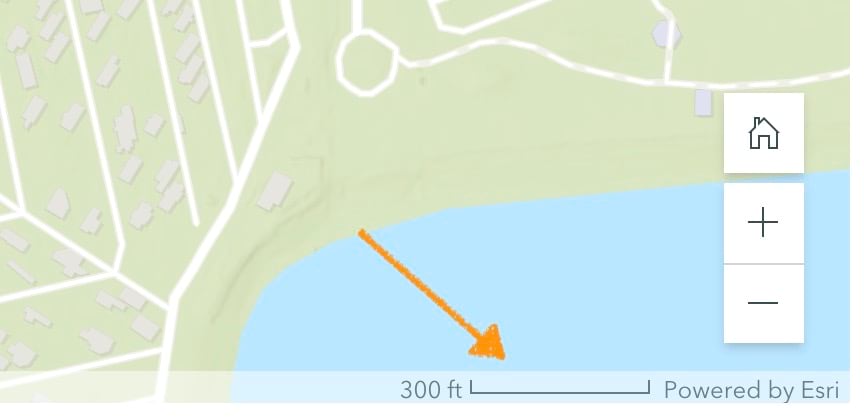
Authors and readers now see a small scale bar in the attribution strip at the bottom of each web map, express map, and map tour in stories. The scalebar will show appropriate units based on the reader’s browser locale settings, and clicking on the scale bar toggles between imperial and metric units.

Accessibility improvements
This month, we are releasing several accessibility updates across the product. For example, screen readers now announce more information about the state of buttons and dropdown menus and provide additional context for when new content is loaded on screen while using the keyboard to navigate a collection. Screen reader announcements and keyboard navigation for browsing collection items for all navigation options has also been enhanced.
And more…
As usual, our team has also spent time on improving performance and stability. We’ve also made several updates and additions in our documentation. For a complete list of changes and fixes, see the Release notes.
ArcGIS Online has also been updated this month, and it gained a lot of new capabilities. Be sure to visit the ArcGIS Blog to read about all the new mapping capabilities. Generally, all the new renderers and features that you can use in the map viewer are available for use in ArcGIS StoryMaps (such as viewing related records in pop-ups). For more information about new capabilities in ArcGIS Online, see these articles:
- What’s New in Map Viewer (November 2022)
- Aggregation-o-rama! Binning, Clustering, and Clustered Pies Now in Map Viewer
- Rolling Out Related Records in Map Viewer
- What’s New in ArcGIS Online (November 2022)
Banner photo by Joshua Hanson on Unsplash


Article Discussion: