At the ArcGIS Enterprise 11.4 and ArcGIS Pro 3.4 releases, the ArcGIS Defense Mapping extension contains significant updates including enhancements to the product data files that ship with the extension for use across both the Pro and Enterprise platform.
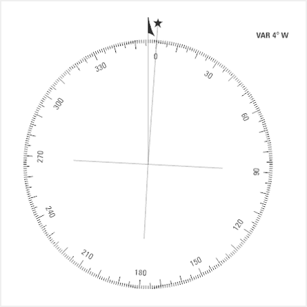
Compass rose north arrow
One of the enhancements at this release is a new compass rose topographic north arrow that includes a 360-degree dial. It is implemented like the other surround element and can be found in the Additional Surrounds gallery under the Topographic elements. This north arrow is primarily designed for the Evasive Chart (EVC) map product, which is now a supported map product with the Defense Mapping extension.

The 360-degree dial is oriented toward Magnetic north.
Product data files
At the 11.4 and 3.4 releases, the product data files included with the ArcGIS Defense Mapping extension contain new and updated items.
MTM25
The extension added support for the Multinational Geospatial Co-production Program (MGCP) Topographic Map (MTM) at a 1:25,000 map scale. This included files for its layout, and bridge and building offset rules:
- pagx
- xml
- xml
This addition spans across both ArcGIS Pro and ArcGIS Enterprise with entries in the DMDProducts.json and DMSProducts.json, respectively.
Evasive Chart
Support for the new EVC map product meant a lot of new files.
Style file
Prior to this release, some different map products shared style files. Now, the product files include individual style files for each supported map products. The new EVC map product is no exception as an EVC.stylx file has also been added to ensure that support for it is complete.
Layout files
Layout files for the EVC map product are available with the product files at this release. Because EVCs are double-sided, two .pagx files have been added: an EVC_Front.pagx file for the front and an EVC_Back.pagx file for the back.
Other EVC support files
A new EVC cartographic database (EVC.gdb, EVC.gdb.zip) has been added for the EVC map product.
Part of the cartographic refinement process employs three refinement rule files. They have been built out for the EVC map product. This includes the following:
- xml
- xml
- xml
While some files meant for other map products could be used to produce the EVC map product, official ones specifically for an EVC have been added:
- EVC_BaseMap_Single_NE.xml
- EVC_BaseMap_Single_NE_80-90NS.xml
- EVC_BaseMap_Single_NW.xml
- EVC_BaseMap_Single_NW_80-90NS.xml
- EVC_BaseMap_Single_SE.xml
- EVC_BaseMap_Single_SW.xml
- EVC_BaseMap_Zipper_NE.xml
- EVC_BaseMap_Zipper_NW.xml
- EVC_BaseMap_Zipper_SE.xml
- EVC_BaseMap_Zipper_SW.xml
- EVC_RegionalReferenceDiagram.xml
Existing map products
While developing files for EVCs, all the files, regardless of intended map product have been heavily updated for a hard refresh. There were extensive updates to label expressions and logic, new symbols were added, and symbology changes made to the following to meet industry specification standards:
- JOG 1.2
- Topographic Map (TM)
- MTM 1.3
Minor items
Some minor items include tweaks to rules that govern at which map scale symbology will display polygon features as point features, and fixes for minor bugs in existing map products such as a subtype naming typo. A layer name for the Joint Operations Graphic (JOG) map product was updated to reflect a color change made to the standard specification. Lastly, continued removal of Spot Color descriptions that followed number codes in Spot color names has been completed to include layout surround elements.
Area of Interest indexes
The MapIndex geodatabase file has been updated to meet new specifications. This file contains the Area of Interest indexes for multiple map products.
ArcGIS Pro tools
The Topographic Production toolbox has a new tool along with other enhancement to existing tools at this release.
Calculate Metrics
When using the Calculate Metrics tool, you can limit the data overwritten to null values using a new Only populate NULL values parameter. When the check box for this parameter is checked, the tool spares existing values and only calculates values for fields that are empty or have a “null” value.
Generate Adjoining Sheets Features
The Generate Adjoining Sheets Features tool was enhanced to allow for fine tuning of how many sheets are included in an adjoining sheets diagram when working with a custom area of interest (AOI).
Typically, you would see nine sheets in the diagram. This consists of the area of interest sheet and the eight bordering sheets. The eight sheets are selected and included in the diagram when the Scale parameter value is defined. This value corresponds to other values associated with the map specification being generated, which are fed into a buffer process.
At ArcGIS Pro 3.4, the buffer size is exposed as a new parameter that appears when the Scale parameter’s new “None” option is chosen. On a custom AOI, you can define the size of this buffer. The surrounding sheets that fall within the buffer will be included in the adjoining sheets diagram.
Generate Isogonic Lines
The toolbox has a new Generate Isogonic Lines tool that, well, generates isogonic lines. The National Geospatial-Intelligence Agency (NGA) has Lines of Equal Magnetic Variation databases that it updates every five years. This new tool is for organizations that are unable to populate an existing feature class using these databases and need to generate their own data that is used to generate the isogonic lines.
Isogonic lines are smooth curved lines that connect a series of points that have an equal magnetic variation value. Different map product specifications require different line feature styles.
The new tool computes the points, and uses the Calculate Magnetic Components tool to calculate the declination value (the angle between geographic and magnetic north) for these points based on the World Magnetic Model. The tool then creates line features that connect the points with equal magnetic variation and populates an existing feature class with the line features.
Generate Product Layout
The Generate Product Layout tool can generate the EVC map product. EVC Front and EVC Back entries have been added to the JSON file (DMDProducts.json) that controls what products the Generate Product Layout geoprocessing tool supports in ArcGIS Pro.
Guide To Numbered Features bookmarks
The Guide To Numbered Features layout element now allows you to create bookmarks for the numbered features in the element. This allows you to access features in the element from the Bookmarks tool in the Pro ribbon.
Deprecation
The tools in the Workflow toolset have been deprecated. These tools were intended to be used as steps in workflows using Workflow Manager (Classic), which is deprecated at ArcGIS Pro 3.4.
Enterprise Map Production System web app
The enhancements included with the extension don’t stop there. At the Enterprise 11.4 release, new functionalities have been introduced to the Map Production System (MPS) web app.
MTM25 support
We mention it briefly earlier in this post, but the new MTM25 map product is supported in Enterprise. This means that once you have configured the MPS app to your Enterprise deployment, you can use it to export MTM25 map products.
Export settings
The app also has new functionalities for administrators. They can specify how often job statuses are refreshed in the Map Exports Status pane of the app for your organization’s members that are using the app. On the same token, app administrators can specify how many service requests can be submitted over a specified period.
Learn more about these settings
Batch options
The Map Exports Status pane in the app has been updated with more options in a toolbar so that you can perform batch operations to the selected jobs. You can now select multiple jobs by pressing the Ctrl key while you click jobs. Alternatively, you can click a job and then another while pressing the Shift key to select a range of jobs. Once selected, the toolbar offers the options to cancel, delete, or download jobs.
The toolbar also now displays the total number of jobs, as well as the number of jobs selected. This comes in handy when the list of jobs is longer than what can be displayed in the pane.
Branding
To support your organization’s branding, the appearance of the app can be further modified now with a new splash screen option. Simply specify an image when configuring the app and voila, the image will appear when the app is loaded.
But wait developers, there’s more
Last and certainly not least, the extension’s REST API has been enhanced.
MTM25 support
Just like with Enterprise and Pro, the MTM25 map product is now supported.
ArcGIS Server
Standalone ArcGIS Server deployments are also now supported, meaning that you could technically use the Topographic Production Service without an Enterprise portal website.
SelectionOperation operation
The SelectionOperation operation, which is used to select and update a the field value for a feature class, can now update multiple feature selections more efficiently because you can combine operations and additional elements are supported in the expression syntax.
Service definition
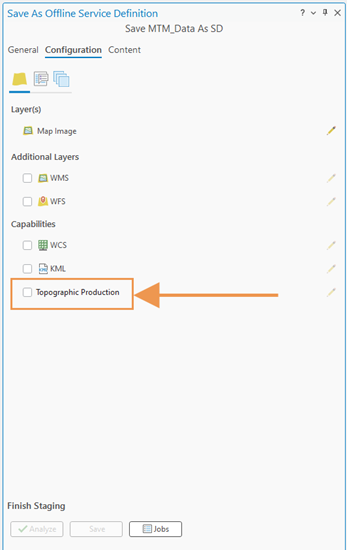
When saving an offline service definition (.sd) in ArcGIS Pro the Topographic Production capability was not an option prior to this release. The .sd file can be used to publish a service in ArcGIS Server Manager. Now, the extension’s Topographic Production capability is included.

Raster outputs
You can further tailor the Defense Mapping extension by changing the resulting raster format so that it meets the needs of your organization. Typically, when exporting a map product using the server-object extension (SOE), the raster for a region is clipped to the output’s area of interest (AOI), including a buffer. The resulting output also contains a raster in the same format as the regional raster.
At this release you can specify a different raster format when using the generateProduct operation. This means that while the regional raster could be in a TIFF format, you can derive an output file in a .dt2 or other raster format. Options include:
- .dat
- .dt2
- .img
- .jp2
- .tif
- .mrf
- .crf
Error messaging in HTML
Lastly, errors returned by the Topographic Production Service REST endpoints are now supported in HTML format. Prior to this release, an error could occur and you may not have noticed. You would need to switch to the JSON format and run the endpoint again to see a message. Now, any error messaging appears when using the HTML format as well.
We hope you can take full-advantage of these enhancements as we continue to develop and improve the extension for the next release. Thanks for reading!

Commenting is not enabled for this article.