At the ArcGIS Pro 3.3 release, the ArcGIS Production Mapping extension has been enhanced to include a new Glossary Table element and the product data files have been updated. Enhancements were also made to the Topographic Production toolbox, which is included in ArcGIS Pro when the Production Mapping extension is licensed.
Glossary Table
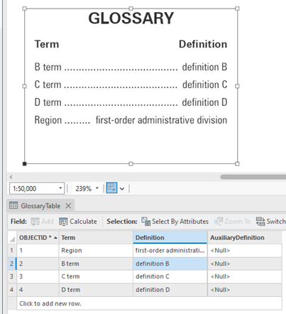
The Glossary Table element is simply a table with terms and definitions. Typically, they contain the translation for a term in each of its rows and are found on layouts.
Prior to this release, the terms in these rows were each a layer in the Contents pane of ArcGIS Pro. This could result in challenges when adjusting the Glossary Table element or updating values because some settings, such as positioning, for a layer could impact another layer. You’d also need to hunt a bit amongst what can become an extensive list for the layer that you want to modify.
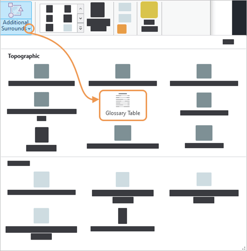
Now, the element can be dropped in from the Additional Surrounds gallery in the Topographic section.

By default, the Glossary Table element is not included with the layout included with the product files, however, you can still take advantage of the improved element by creating a standalone table to use as the source of inserted element.

Once the element is inserted on your layout and pointed to a source, you can open the standalone table and modify its values. The Glossary Table element will reflect the values provided. The layout may need to be refreshed.

Just like other surround elements, you can modify the Glossary Table element’s properties in the Element pane. This includes the title, column headers, and other options.
Product files
Other enhancements to the product files have been made.
Spot colors
When it comes to printing, an alternative to Process colors, or CMYK, is Spot colors. Spot colors, which can be used in addition to Process colors, are more exact and rely on the printer and paper that is used.
At this release, all the Spot color descriptions for items included with the product files were updated at this release to streamline PDF print processes.
This includes:
- All symbols and labels in layouts
- All the colors in the style files for TM and MGCP map products
- The masking rule files used when finalizing a map product
Geoprocessing tools
At ArcGIS Pro 3.3, there were several enhancements to the Topographic Production toolbox.
First, the Generate Elevation Guide Features and Generate Location Diagram Features tools have a new parameter to determine whether islands or holes are included in the output features. The value provided for the new Minimum Island Area parameter is the minimum area required, anything less and the feature will be excluded when the tool is run.
The process to rotate point features so that they point downhill is no longer a manual one. The Calculate Metrics tool can rotate point feature symbology to face downhill by using a digital elevation model (DEM). This means that features such as springs, natural pools, and geothermal outlets can point downhill as necessary. The rotation degree value populates the CBO_Rotation attribute field, which then drives the symbology orientation.
Other tool updates were made to comply with external entities:
- The GeoNames To Geodatabase tool was updated to work with the latest GNS downloadable files.
- The Geodatabase To Shape tool was updated to set the Precision field value for integer data types to 7. This ensures GAIT validation passes, which helps meet the specification requirements for MGCP and MUVD map products.
Thanks for reading, check back soon to learn what’s new for Production Mapping at the ArcGIS Enterprise 11.3 release.
For further information, please visit the ArcGIS Pro page or post your questions in the ArcGIS Production Mapping Esri Community place.

Commenting is not enabled for this article.