Whether you are an analyst tracking the fight against COVID-19 in a metropolitan area, a project manager handling data and layers across your organization, or a student building an online portfolio, it’s important to efficiently share your work. ArcGIS Pro allows you to seamlessly share 2D and 3D maps, layers, geoprocessing tools, layouts, tasks, entire projects, and more.
If you haven’t already made the switch to ArcGIS Pro or if you simply want a refresher on its advantages, below are 10 reasons you should use ArcGIS Pro to share your work.
1. The Share ribbon is intuitive
It’s a special moment when you arrive on the Share ribbon: you’ve built your project, map, or layers from the ground up, created a model or two to run some analyses, and are now ready to share the results with others.

The ribbon has been designed to optimize the sharing experience. Not only is it intuitive and easy to use, but the Share ribbon is also the starting point for discovering new ways to meet your organization’s collaboration needs.
2. New web layer types are supported
The list of web layer types that can be shared from ArcMap has been expanded in ArcGIS Pro. Vector tile layers, web scene layers, and web elevation layers are all exclusive to ArcGIS Pro.
Share vector tile layers for fast map visualization. If you have 3D data, share web scene layers and web elevation layers. Share rasters as web imagery layers. Web layers such as web tile layers and web scene layers are cached to improve drawing and visualization performance. Some scene layers can be published from scene layer packages, while others can be published from associated feature layers for use in editing workflows. A web layer with an associated feature layer allows you to modify capabilities such as definition queries and symbology, or use geoprocessing tools to further your analysis.
3. Share selected layers as web layers
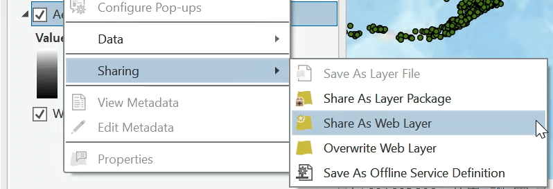
If your ArcGIS Pro map contains multiple layers, you can share one or more selected layers as a web layer. Select the layers in the Contents pane, right-click any selected layer, point to Sharing, and click Share As Web Layer.
4. Share web maps and web scenes
The ability to share web maps and web scenes is exclusive to ArcGIS Pro. Web maps and web scenes are interactive displays of geographic information built on 2D and 3D data from existing web layers or data layers shared with your map or scene. They can tell powerful stories and answer important questions. For example, help tourists visualize downtown San Diego by sharing a web scene viewable with a web browser.
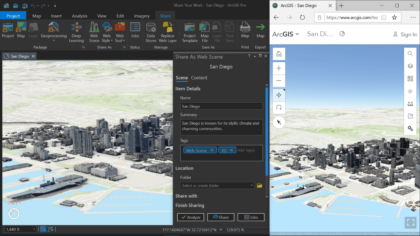
The ability to update existing web maps was added in ArcGIS 2.6. You can save updates to web maps in your ArcGIS organization. This workflow allows you to modify and save existing maps used in your custom web apps directly from ArcGIS Pro. Want to keep the previous version of the web map? Ensure the archive option is enabled before you save.
5. Publish services to a stand-alone ArcGIS Server
Myth: It is not possible to publish to a stand-alone ArcGIS Server with ArcGIS Pro.
Fact: Not only can you publish map services in ArcGIS Pro, but you can also publish other services such as image services, geocode services, and geoprocessing services to stand-alone servers.
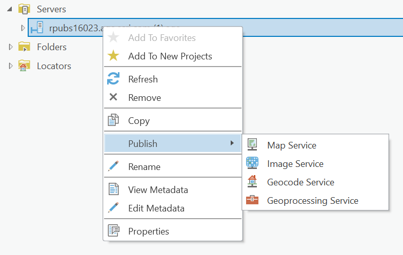
Connect to an ArcGIS Server and sign in to an account with sufficient privileges to begin publishing services. Publish services from ArcGIS Pro that support shared instance pooling to conserve memory resources on server machines.
See Configure a map service for more information.
6. Use functionality that supports advanced workflows
To help you keep up with data-intensive work, ArcGIS Pro provides functionality that supports advanced editing and updating workflows. The following are a few of our favorites:
- Enable additional layers and capabilities—Take advantage of extra functionality when you share map image layers to ArcGIS Enterprise. Linear referencing, network analysis, utility network, trace network, validation, and version management are all supported when publishing data-specific layers. Enable Web Coverage Service (WCS), Web Feature Services (WFS), and Web Map Service (WMS) to include additional items in your portal content. For a complete list of extensions, see Additional layers and capabilities.
- Overwrite or replace web layers—In ArcMap and ArcGIS Pro, you can overwrite existing web feature layers and map image layers along with their pop-ups and symbology. However, ArcGIS Pro allows you to also replace web tile layers, vector tile layers, and web scene layers to switch out layer content with zero downtime. Both workflows do not change existing service URLs or item IDs.
- Share styles—Do you have a custom style that others in your organization need to use and modify in their maps and scenes? Share 2D, 3D, and dictionary styles as web styles to ArcGIS Online and ArcGIS Enterprise. For more information, see Share a web style.
- Save a service definition—Beginning in ArcGIS Pro 2.7, you can save a service definition and use it to publish to an ArcGIS Online or ArcGIS Enterprise portal or a stand-alone ArcGIS Server at a later time. This important ArcMap equivalency item allows you to create a file that contains all the information needed to publish a web layer or service, such as its properties, capabilities, and service type. See Introduction to saving service definitions to learn more about how service definitions can be used in your organization’s sharing workflows.
7. Manage different portal connections
Are you a member of different ArcGIS organizations and need to frequently share content to different portals? ArcGIS Pro allows you to manage and switch between ArcGIS Online and ArcGIS Enterprise portals. Establish, edit, or remove connections from the Portals page in ArcGIS Pro.
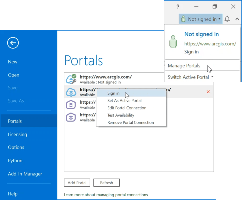
Having multiple portal connections allows you to access GIS resources located on different servers and ArcGIS Enterprise deployments. Use ArcGIS Pro to add and share different content to and from different portals.
8. Take advantage of full metadata on layers
Metadata in ArcMap was only supported for maps. In ArcGIS Pro, we’ve made it easier for you to maintain authoritative metadata by supporting full metadata for maps, group layers, and individual layers. When you share a map image layer or feature layer, the exposed service and its sublayers can store metadata separately. When you publish a web layer that references registered data, the sublayer’s service metadata will recognize updates to the metadata at the data source. This is beneficial in multiuser editing workflows in which the original data sources need to be clearly and regularly maintained.
Learn more about metadata when sharing web layers
9. Save your entire project as a compressed file
Need to share an entire ArcGIS Pro project with a colleague or save an archive of your work as a single compressed file? Packaging a project is an easy way to share or store your completed work. Your project package contains all your maps, data referenced by its layers, folder connections, geoprocessing history, and more. Project packages are an efficient way of moving entire GIS projects across your organization. The recipient can unpack the project by opening the file, access the contents in its last state, and immediately begin viewing and adding to the work.
There’s more! Projects aren’t the only thing you can package. You can package individual maps for offline mobile workflows with a mobile map package or individual layers as layer packages. See Introduction to sharing packages for a complete list of packages you can create in ArcGIS Pro.
10. Sharing jobs run in the background
In the previous sections, we’ve discussed different ways to share your work with ArcGIS Pro. The time it takes to share, publish, or package can range from seconds to a few hours depending on the size and complexity of your GIS resource. That’s why we’ve engineered ArcGIS Pro to process sharing jobs in the background.
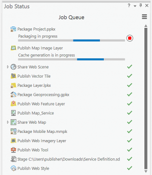
Continue working on your project, start other sharing jobs, or even take a break and close ArcGIS Pro. Check the Job Status pane the next time you open ArcGIS Pro. If it’s a big job, you’ll find ArcGIS Pro still working…just like our teams at Esri, where we strive to improve software with each release.
We’ve covered some good reasons you should use ArcGIS Pro to share you work. But that’s not all… Learn more about how to share with ArcGIS Pro.
Article Discussion: