Microsoft launched the Hub in April of 2021 to provide free compute and applications to their global network of sustainability practitioners. The Hub was very successful in lowering the entry barrier for individual users and researchers to work with the Microsoft Planetary Computer (MPC) and its 24-petabyte library of open data. Through the Hub, Microsoft provided users access to open-source tools and applications for their projects. Microsoft also provided a high-performance python-CPU and python-GPU environment that supported community deep learning algorithms, along with QGIS in a windows virtual machine environment for interactive analysis.
On June 6, 2024, the Hub was officially retired, prompting users with active projects to find a new solution to leverage the Planetary Computer data catalog for geospatial analysis. The good news is that Esri users already have access to an Azure python development environment and a no-code environment for analysis within ArcGIS Pro.
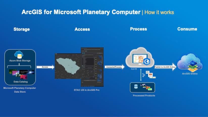
What is ArcGIS for Microsoft Planetary Computer?
ArcGIS for Microsoft Planetary Computer is offered as an Azure solution template that lets users generate a preconfigured ArcGIS Pro virtual machine instance in the same cloud region as the Planetary Computer (Azure Europe West). This Pro instance provides the same desktop analytic environment the user has licensed for ArcGIS Pro—including raster analysis tools (available with ArcGIS Image Analyst), geoprocessing tools, publishing tools, and any extensions the user has purchased and installed. Users launch this virtual Pro instance on demand within their existing Azure environment, avoiding the need to install additional software.
ArcGIS for Microsoft Planetary Computer benefits include:
- Ability to leverage the ArcGIS platform to directly connect to the Planetary Computer data catalog of analysis ready datasets. You can use the pre-configured STAC tools to easily query and filter the Planetary Computer data catalog by location and time.
- Access to configurable CPU/GPU and storage settings needed for advanced analysis techniques over large geographic areas, such as change detection, time series analysis, and deep learning. Use the pre-set machine controls to prevent accidental overcharging when processing takes hours to complete.
- Incorporate advanced Esri Geospatial Artificial Intelligence (GeoAI) tools in your project to perform land cover classification and object detection. The ArcGIS virtual image includes pre-installed deep learning libraries and processing templates that have been customized for the Planetary Computer data catalog.
- Work based on your preferred environment, with no-code options using raster functions from the GUI, semi-automated processing with Model Builder, or full-code via the Python API. Perform on-the-fly processing or apply it globally and persist the results.
- Easily share out insights with members of your organization, decision makers, or the public. Use interactive custom applications and storytelling tools that help translate your analysis results into easy-to-understand content.
Using the Planetary Computer for Environmental Impact
Already, Esri partners have found success using this development approach. During his presentation at the 2024 FedGIS Workshop, Simplifying Imagery Analysis in the Cloud, Dr. Mike Evans shared his experience with ArcGIS and the Planetary Computer. Dr. Evans is a Senior Data Scientist with the Chesapeake Conservancy, a nonprofit organization in Annapolis, Maryland.
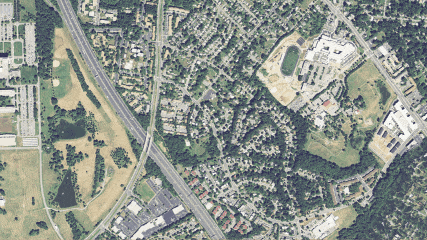
Chesapeake Conservancy, U.S. Geological Survey (USGS) and University of Vermont Spatial Analysis Lab (UVM SAL) have collaborated to produce 1-meter resolution land cover and land use/land cover datasets for the Chesapeake Bay (CB) watershed regional area (206 counties, over 250,000 km2). The production of the CB Program 1-meter “land cover” data involves the identification and classification of image objects derived from aerial imagery (National Agriculture Imagery Program, NAIP), above-ground height information derived from LiDAR, and other ancillary data. The NAIP program provides U.S.-wide, high-resolution aerial imagery, with four spectral bands (R, G, B, IR). Data is captured at least once every three years for each state. By using NAIP imagery, the program can map land cover and land use at the parcel scale. This is incredibly important for environmental decision making in a landscape dominated by private land holdings. Restoration practices are implemented at this scale as well and the high spatial resolution data is critical for mapping opportunities and quantifying benefits of this implementation.
Dr. Evans began his Planetary Computer project using a python-only implementation. In 2024, he chose to extend his code-based workflow to use ArcGIS for Microsoft Planetary Computer for a couple of reasons. First, having one machine to work from across the project, using a single, familiar ArcGIS Pro interface made it easier to collaborate across the team. For the analytic workflow, he was able to collect samples, train the model, and perform interference all in one platform. He likes the integration of the processing results with a set of strong visualization tools to help with the interactive analysis of the results. Finally, Dr. Evans knew that future collaborators would prefer a graphical user interface to refine the deep learning models of their local areas, instead of scripting.
Getting Started with ArcGIS for Microsoft Planetary Computer
For current Esri users with an existing Azure account, you can start using this capability today for no additional charge by bringing your ArcGIS user type and analysis extensions to this environment. The recommended user type for this capability is the Professional Plus. In addition to having access to the ArcGIS Pro Advanced tools, you can also use the ArcGIS Pro extensions, including but not limited to, Image Analyst, 3D Analyst, and Spatial Analyst. This user type also includes additional functionality available outside of the Azure Environment, including access to ArcGIS Online, all its associated applications, and the Esri Living Atlas Data Catalog. If your organization previously had the GIS Professional Advanced license, then it will automatically convert to the new Professional Plus user type.
If you are new to Esri products, you can visit the Esri Store website to view the purchase options for ArcGIS for Personal Use. This version is designed for users who want the same powerful software licensed at home for noncommercial, personal use. Esri offers discounts to Educational and Non-profit users. You can also access additional information and a “getting-started” video on the Azure Marketplace ArcGIS page.


Article Discussion: