The ArcGIS Pro 3.3 release is here and with it comes a collection of new offerings from the Geodatabase Team. I’ll give an overview of the main features we’ve added this release and then we can dig deeper into some of them in future posts.
Here’s a snapshot of our new features:
- Convert Schema Report Tool
- Import XML workspace document tool enhancements
- Export Attachments tool
- Generate domains from existing values
- Attribute Rules analyzer improvements
- Extract Data from a geodatabase
- Administrator configuration options for versioning and geodatabase replication
- Query Layer improvements
- GDB Potpourri – A collection of other notable updates
Convert Schema Report tool
In ArcGIS Pro 3.2 we added the Generate Schema Report geoprocessing tool that allows you to export your geodatabase schema to a report in various formats (XLSX, PDF, HTML, JSON). This was a heavily requested feature and we’re happy that it’s gotten a good reception and lots of useful feedback on the community page that we set up.
In a blog post from last release I mentioned that this was the first phase of the project. Our real goal was always to be able to support schema editing directly in the report. That is to say, exporting the report, making schema changes directly in the Excel file or JSON, and then importing that into a newly created geodatabase. The new geodatabase will then be a representation of your new data model with all of the schema changes made in the report.
With ArcGIS Pro 3.3 we’ve enabled this workflow via a new geoprocessing tool called Convert Schema Report. This tool allows you to take a schema report that you’ve generated in JSON or XLSX and convert it to another format (JSON, PDF, HTML, XLSX, or XML). To complete the schema report editing workflow mentioned above, you can use this tool in conjunction with the Import XML Workspace Document tool.
We’ll put a separate post together with tips about this schema editing workflow and using the new Convert Schema Report tool. In the meantime, this short vid gives a nice overview:
We’ll also be offering a comprehensive demo theatre on this at the User Conference this year so stop by and check it out if you’re down in San Diego. It’s called Geodatabases: Generating Schema Reports.
Import XML workspace document tool enhancements
ArcGIS Pro 3.3 also became the perfect time to make some overdue improvements to the Import XML Workspace Document experience since we were already raising the profile of it with the whole schema report editing workflow mentioned above.
With the new release we’ve added a wizard when you are importing an XML workspace document. The first page of the wizard lets you choose the XML file and whether you’d like to import with data or schema only. And on the second page we’ve added a new data grid. This acts as a preview for the schema that you’ll be importing. But it also allows you to address any naming conflicts and define configuration keywords for the schema elements being imported.

Export Attachments tool
This one has a nice story. It started as an idea on the community pages. Then we put some sample tools in a blog post to help out with it. Then we decided it was so helpful we should just put it right in the core software. Eh voila!
Now with ArcGIS Pro 3.3 you can use the Export Attachments geoprocessing tool to dump all of the attachments associated with a table or feature class into a designated folder. Only want to export attachments for a selection of features? It does that too.
The tool has also been thoughtfully designed with numerous ways to rename the attached media as well as organize the exported items into sub-folders during the export process.
Below is a short vid to see the tool in action. We’ll get a follow-up blog on this going as well.
Generate domains from existing values
This is a nice productivity enhancer for creating domains much more quickly. When you are creating a new domain on a field, instead of manually adding a list of codes and descriptions or range of values, you can now have any existing values on that field auto-magically populate the domain.
We’ve added two new options to the domain dropdowns in both Fields and Subtypes views:
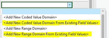
Choosing one of these options will scrape the field for existing values, then open Domains view with those values pre-populated (codes and descriptions for coded value domains, or min and max values for range domains). Then all you need to do is update the new domain’s name and description and hit save.
Attribute Rules analyzer improvements
We’ve improved the experience when you’re publishing a web map that contains features with attribute rules. When you share layers with validation or batch calculation attribute rules that have the Validation capability enabled, all four error tables must be present in the map view. Similarly, if a table or feature class that is referenced by a rule is not included in a map you will also get a warning.
Previously, when you received these warnings you would have to go back to the Catalog pane to scroll and search for the missing items and add them to the map, then attempt to publish again. With Pro 3.3 you can simply right click the warning error in the Sharing pane and click Add to map. So, a helpful time saver there.
Extract Data from a geodatabase
This was an outstanding ArcMap equivalency issue that we’re happy to have finally gotten to in Pro 3.3. People liked the malleability of the Extract Data Wizard in ArcMap and we’ve added the Extract Data From Geodatabase geoprocessing tool with that same functionality.
It works like a copy/paste operation, bringing data from one geodatabase to another, but also allows you more granularity by:
- Offering the option to extract the schema and data or just schema only.
- Honoring selections and definition queries on the data being extracted.
- Allowing you to set an extent and extract only that subset of the data.
- Allowing you to opt in or out of also extracting related features (e.g., via relationship classes) or dependent datasets (e.g., topologies and networks).
Administrator configuration options for versioning and geodatabase replication
This one is for system admins who want to lock down specific application settings for ArcGIS Pro before deploying it across a team or organization. We’ve exposed options for versioning and geodatabase replication that you can configure in a Pro.settingsConfig file prior to deployment. This lets you lock in certain settings or set different defaults than what they usually are for the application.
For example, if you’d like all new versions to be created as branch versioned by default, you can configure the app to do that.
Query Layer improvements
- You can now update the extent of a query layer in the Layer Properties dialog box.
- You can also use a new shortcut key to get to query layer properties. This lets you quickly update the query as you’re exploring your data. With a query layer selected in the Contents pane, press Ctrl+Q to open the Edit Query Layer dialog box.
GDB Potpourri
Finally, here’s a collection of other notable nuggets that we’ve added in Pro 3.3:
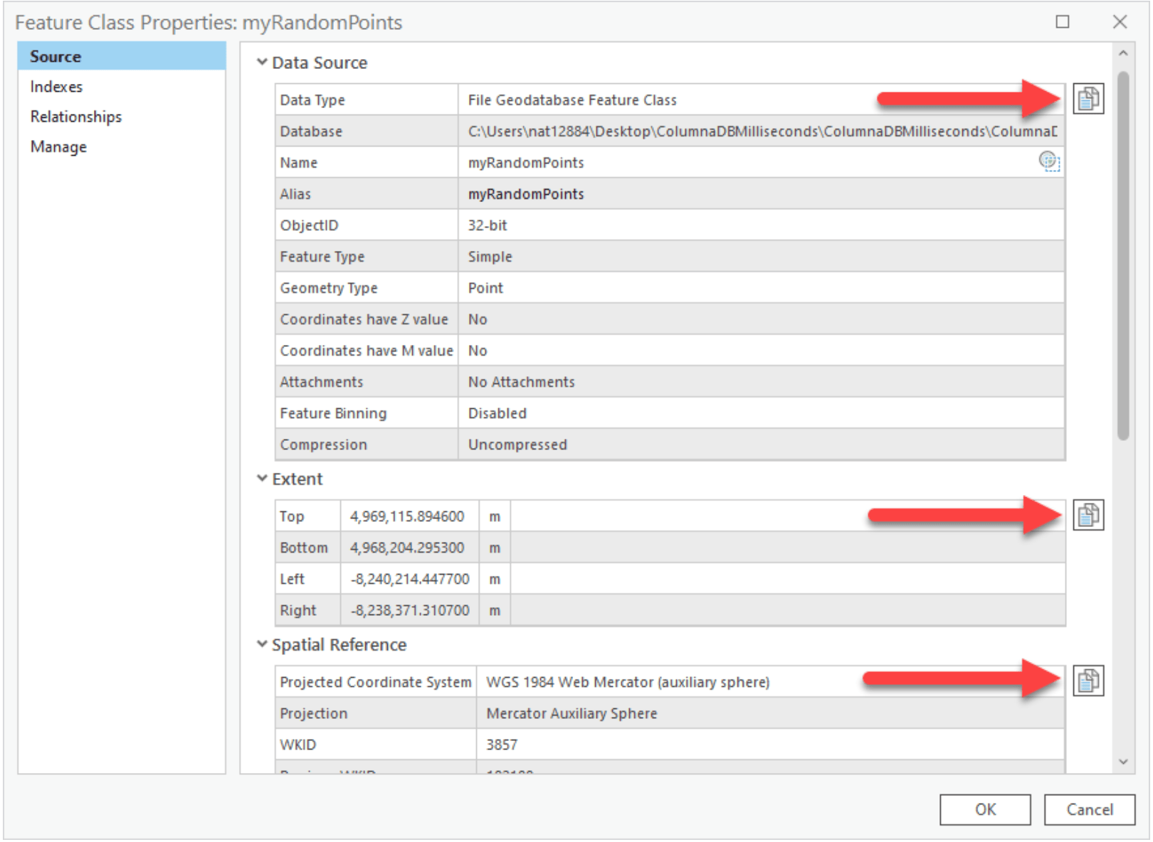
- There are new Copy icons on the feature class properties page to quickly capture data such as the data source info and extent or spatial reference settings.
- You can also properly copy and paste domain values from Pro to Excel now.
- You can edit or recalculate the extent of a feature class on the Feature Class Properties dialog box.
- We’ve made the New Version command more accessible by putting it on the right-click context menu of a data source in the Contents pane (list by data source).
All in all, another good haul of new features, updates, and enhancements for the Pro 3.3 release from the Geodatabase team. We’ll post some follow-up blogs on some of this functionality soon.
If you’re still hungry for info, remember to snack on the delicious Geodatabase Resources Hub that we baked last release. A more app-wide look of what’s new can be found in the What’s New documentation. And as always, continue to post to the ideas site and engage on the community pages. We have been listening and, as you can see release-to-release, a lot of these features and enhancements are getting pulled directly from there.
Enjoy ArcGIS Pro 3.3! Hopefully I’ll see some of you at the User Conference in a couple of months.

Commenting is not enabled for this article.