With increasing capabilities to measure and model the world around us, netCDF (Network Common Data Form) has become a widely used format for analyzing and sharing multidimensional scientific data. ArcGIS Pro now allows you to describe the nature and contents of netCDF datasets—listing their dimensions, variables, and associated attributes—by specifying a netCDF file as input to the Describe NetCDF File tool. To save this information for future reference, you can specify an output text file. Regardless of whether you specified an output description file, the tool displays the description directly in the Geoprocessing Messages pane, which you can also access from the History pane in an ArcGIS Pro project. See the following video for a quick overview:
Let’s use the Describe NetCDF File tool to understand the structure and contents of netCDF datasets.
In ArcGIS Pro, search for the Describe NetCDF File tool. After opening the tool, under the Input NetCDF File parameter, click the Browse button to specify the input netCDF file. Browse to the location of a netCDF file and select it.
The following example uses the NOAA Monthly U.S. Climate Gridded Dataset (NClimGrid). To save the output description, specify a path and file name in the Output Description File parameter. You can choose from the following formats:
- Text file (.txt)
- Markdown file (.md)
- Common Data Language (CDL) file (.cdl), which is a human-readable text representation of the netCDF file’s header and structure
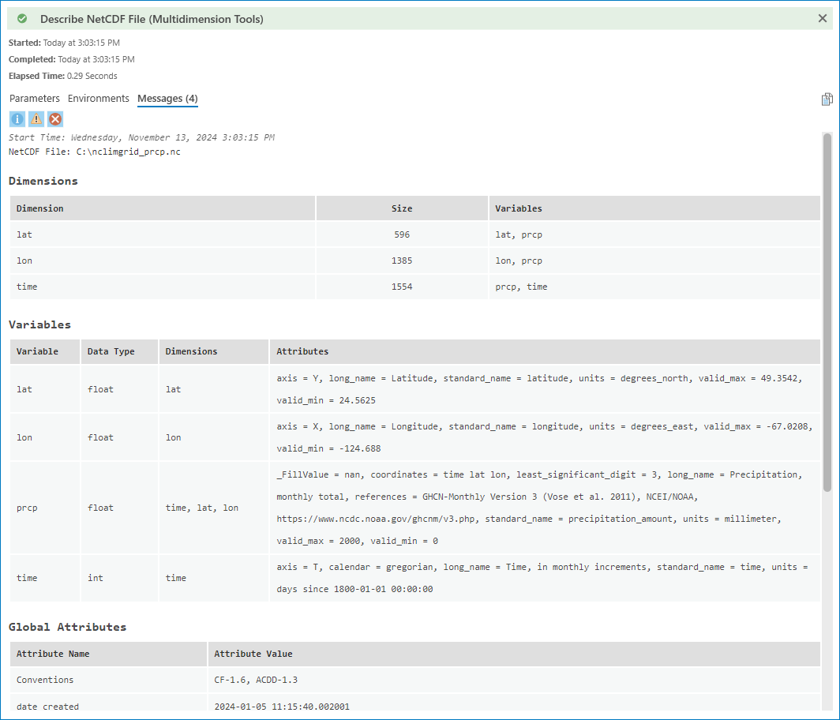
After the tool runs, you can click View Details from the status banner and go to the Geoprocessing Messages pane to view the output description of the netCDF file’s contents. The output includes the following information:
- NetCDF File path—Confirms the file that was accessed
- Dimensions table—Lists all dimensions in the file, such as time, latitude, and longitude, along with their sizes
- Variables table—Provides detailed information about each variable, including associated dimensions, data types, and attributes.
- Global Attributes table—Displays metadata that applies to the entire dataset, such as title, institution, source, and history.
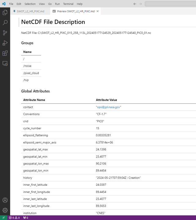
The description is also saved as a text file if you specified the Output Description File. By choosing the .md format, you can view the output in a more visually formatted way, making it easier to read with a markdown viewer or editor such as Visual Studio Code, Typora, or GitHub.
Some netCDF files may contain groups, which allow data to be organized hierarchically within the file, – similar to folders and subfolders. This is especially useful for complex datasets. In that case, you’ll find that the Groups table has been added to the top of the output.
Once you have reviewed the variables and structure of the netCDF file, you can determine which ArcGIS Pro tool best fits the data. For example, you can use Make Multidimensional Raster Layer for grid-based variables and NetCDF Points To Feature Class for point-based data.
This is how the Describe NetCDF File tool in ArcGIS Pro explores and understands complex netCDF datasets. Whether you’re new to netCDF or looking for a more efficient way to inspect your files, this tool provides a solution to work with multidimensional scientific data.
References:
NOAA. (2024). NOAA Monthly U.S. Climate Gridded Dataset (NClimGrid). National Centers for Environmental Information. Retrieved from https://www.ncei.noaa.gov/access/metadata/landing-page/bin/iso?id=gov.noaa.ncdc%3AC00332
JPL. (2024). SWOT Mission Data. NASA Jet Propulsion Laboratory. Retrieved from https://podaac.jpl.nasa.gov/SWOT?tab=mission-objectives§ions=about%2Bdata


Article Discussion: