Imagine waking up to sunny skies only to see them transform into a dangerous storm by the afternoon. Tornadoes tearing across the plains, hail pelting down on rooftops, or powerful winds uprooting trees—these severe weather events are a reality for many communities. Understanding when and where these events occur is essential for preparation and mitigation. This blog will guide you through a workflow to explore severe weather patterns using the Space Time Kernel Density tool in ArcGIS Pro’s Spatial Analyst extension.
Severe Weather Climatologies
Severe weather climatologies, like the ones produced in this blog, provide a long-term statistical representation of weather patterns and risks. They are essential for understanding the spatial and temporal distribution of phenomena like tornadoes, hail, and damaging winds. These climatologies inform emergency management, logistics, urban planning, agriculture, and public awareness. By mapping severe weather patterns, we can identify trends that help protect lives and property.
The Results
Using Space Time Kernel Density, we visualized the patterns of severe weather events through space and time (this process is described later in this blog). We summarized hail, tornadoes, severe thunderstorm wind, and all these events combined. Each map shows the daily probability of severe weather occurring in each cell, with warmer colors representing a higher risk of severe weather events. These maps help reveal recurring seasonal patterns and regional hotspots.
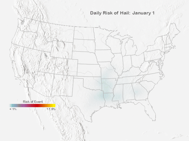
Daily risk of hail. The risk value can roughly be interpreted as the probability that an extreme weather event will occur on that day within 80 km of the location. A hosted imagery layer for use in visualization and analysis workflows is available here.
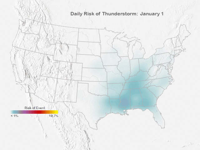
Daily risk of thunderstorm wind. The risk value can roughly be interpreted as the probability that an extreme weather event will occur on that day within 80 km of the location. A hosted imagery layer for use in visualization and analysis workflows is available here.
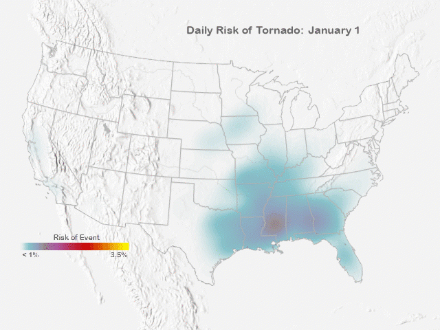
Daily risk of tornado. The risk value can roughly be interpreted as the probability that an extreme weather event will occur on that day within 80 km of the location. A hosted imagery layer for use in visualization and analysis workflows is available here.
Potential Applications
Emergency managers can use these patterns to prioritize resources in high-risk areas during times that severe weather events are most likely to happen. City planners can incorporate these maps into infrastructure design, ensuring buildings and utilities can withstand extreme weather. Researchers can also identify trends tied to climate variability and change, highlighting areas for further study. The animations also help communicate weather risks to the public in an accessible format.
Analysis details
This analysis builds on NOAA’s well-established techniques for severe weather climatologies but uses Space Time Kernel Density to calculate probabilities of severe weather events across space and time. The input data comes from NOAA’s Storm Events Database, which documents significant weather events with sufficient intensity to cause loss of life, injuries, or substantial property damage. The database contains point locations and includes date ranges for each event type: hail (1955–2023), tornadoes (1950–2023), and severe wind (1955–2023). In total, the dataset used includes 74,299 tornadoes, 494,107 severe wind events, and 379,295 hail events.
These event points were processed using the Space Time Kernel Density tool. For this analysis, a spatial bandwidth of 240 kilometers, a temporal bandwidth of 30 days, and a cell size of 80 kilometers were specified (roughly equivalent to the values used by NOAA). The tool calculates smoothed density values and converts them into expected counts, representing the probability of severe weather occurrence at each location over time. Additionally, the kernel smoothing helps address locational and temporal uncertainty in the dataset, mitigating inaccuracies in the reported event coordinates.
Once the expected counts were generated by the kernel density tool, they were aggregated into recurring daily values (one map for each Julian day of the year) using the Aggregate Multidimensional Raster tool. This step created daily averages for each location, representing the likelihood of severe weather on any given day of the year. The resulting data allows you to explore spatial and temporal patterns of severe weather risk while accounting for data limitations and seasonal variability.
Where to go from here
- Refine the study by adjusting spatial and temporal bandwidths to see how the patterns change.
- Investigate additional types of severe weather events, such as flash floods or extreme heat, to expand the scope of the climatology.
- Explore event severity, such as hailstone size or wind speeds, to better understand their spatiotemporal patterns.
Severe weather is a persistent challenge, but with tools like Space Time Kernel Density and the power of GIS, we can improve our understanding of its patterns and prepare for its impacts. This workflow offers a practical starting point for analyzing severe weather.


Article Discussion: