
Estimated Read Time: 5 minutes
Do you remember in school when your teacher would write notes on a whiteboard (or chalkboard, depending on your age) as they spoke? After each lesson, they would erase the board to make space for the next topic.
Now, consider your current work habits in ArcGIS Pro. You run numerous tools multiple times a day. By default, you save all your output datasets to the project geodatabase via the Workspace geoprocessing environment.
What if I told you, you could work faster and stay more organized using the whiteboard instead?
That’s precisely what writing geoprocessing tool outputs to the memory workspace allows you to do! Instead of saving your output datasets to a database or folder on disk (or on a network), you can store temporary datasets in memory, just like writing notes on a whiteboard.
In this blog, we will explore what the memory workspace is, its benefits, and some new updates in ArcGIS Pro 3.5.
About the memory workspace
The memory workspace is a powerful, yet underutilized feature that enables you to store temporary data directly in your computer system memory. Memory, also known as RAM, is a computer’s “short-term” memory. When you write a tool’s output feature class, raster, or table to the memory workspace it will only exist during the active session, and once ArcGIS Pro is closed, the memory is cleared.

Note: If you want to clear the memory workspace without closing Pro, just use the Delete tool and specify memory as the input.
Because memory datasets are stored in your computer’s RAM, they cannot be viewed from the Catalog pane or view in a database or folder connection. But layers with a memory data source will display on the map and are listed in the Contents pane.

Memory Workspace Advantages
You may be thinking, why would I want a dataset to automatically delete itself? There are advantages and situations where it may be beneficial to save tool outputs temporarily:
- You need a quick answer ASAP, not something that you can return to in the future. Writing data to the memory workspace is often considerably faster than writing to a database or folder.
- You are running a workflow with many steps, and you do not want to manage or keep intermediate datasets, rather, you only need the final output dataset. Use memory to temporarily store intermediate output datasets.
It’s important to efficiently manage your data to keep your projects organized. Without a clear strategy you run the risk of cluttered folders, redundant datasets, and it can be difficult to keep track of different results run at different times. The memory workspace can be used for faster processing as well as improved data management and organization!
What’s the catch?
There are some precautions you may want to take when using the memory workspace:
- Because memory datasets are stored in the system RAM your system may run low on memory if you write large datasets to the workspace. This can negatively impact processing performance.
- You cannot write output files like
.shp,.txt,.kml, etc. or folders to the memory workspace.
Learn more about memory workspace limitations
How to write to memory and Pro 3.5 enhancements
You can utilize the memory workspace from the tool dialog box, ModelBuilder, or even in Python scripts! You can use the following methods to write any output feature class, table, or raster to the memory workspace for faster processing:
- New in ArcGIS Pro 3.5, you can click the memory workspace button
 on an output parameter on the tool dialog box to automatically set the output path to
 memory\. The existing or default dataset name will be maintained. - Type
memory\and a name as the output path on a tool’s output parameter.

Example: Use the Memory Workspace to store intermediate datasets in ModelBuilder
Objective: Create a model to find potential Venus Flytrap habitats in the Carolinas, USA. The model will use the memory workspace for all intermediate outputs for faster processing and easier data management.

Venus Flytraps are unique, carnivorous plants known for their mouth-like hinged lobes with trigger hairs that allow the mouth to shut when touched by prey. They are native to the longleaf pine habitats of the coastal plain and sandhill ecoregions of North and South Carolina. And historically, they are known to grow within a 100-mile radius of Wilmington, NC.
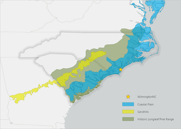
In 2016 the U.S. Fish and Wildlife Service was petitioned to protect Venus Flytraps under the Endangered Species Act. But in 2023, the service determined that due to successful conservation efforts, the Venus Flytrap does not face an immediate threat of extinction.
Despite this, Venus Flytraps still face threats from habitat loss caused by agriculture, development, fire suppression, and poaching.

Using ModelBuilder, let’s build a geoprocessing workflow to identify the potential Venus Flytrap habitat locations.
Create a model that uses the following tools and steps:
- Pairwise Buffer: Define a 100-mile buffer around Wilmington, NC.
- Intersect: Find the intersection between the 100-mile buffer, ecoregions, longleaf pine habitat, and fire suppression avoidance areas.
- Pairwise Erase: Remove all agricultural and developed land cover areas from the potential habitat locations.
Use the memory workspace for the Pairwise Buffer and Intersect tools output, since we do not want to keep those results and want the fastest performance possible. Use the project geodatabase for the final output of Pairwise Erase, as we want to keep that dataset for review and sharing the results.

By running the tool with memory workspace outputs for the intermediate steps, the model completes in 2 minutes, which is faster than writing to the file geodatabase for all steps. And you will not get any intermediate outputs cluttering your project database.
The model output shows the potential habitat locations of Venus Flytraps.

Summary
In ArcGIS Pro 3.5, writing data to the memory workspace can be done with the click of a button! You can also type memory\ and an output name on most tools in the Geoprocessing pane, ModelBuilder, or Python.
The memory workspace is a temporary database stored in your computer’s RAM, which is automatically cleared when ArcGIS Pro is closed. So, you should only use this workspace for intermediate steps and outputs you don’t need to keep. When used correctly, the memory workspace is a powerful alternative for faster processing and efficient data management.


Article Discussion: