This blog article was originally published on June 20, 2012, and has been updated. The last previous update was April 18, 2018.
Live feeds provide real-time updates and information, enabling you to stay current with events as they unfold. This is crucial in situations where up-to-the-minute information is essential, such as emergency response or keeping track of live events.
Map authors can take advantage of live feed feature services published via ArcGIS Living Atlas. Other products such as ArcGIS Velocity or ArcGIS GeoEvent Server can also be used to incorporate real-time information in maps. Similar capabilities using using files and RSS feeds can also add “live” context to your maps.
CSV and text files
Comma-separated Value files (CSV) and text files can be added from local files or referenced from URL locations on the Web. If they contain lat/long data, they can be used to add features to your map either by creating hosted feature layers or by reference from their URL location.
An interesting feature of adding CSV files containing locations to your map via URL, is that each time you open your map, or otherwise refresh the map or layer, the data is updated from its source location. This means that if the CSV or text file has changed, the map will reflect those changes.
GeoJSON
Based on the JavaScript Object Notation (JSON) format, GeoJSON is an open standard format designed for representing simple geographical features along with their attributes. Similar to CSV, you can add GeoJSON files and publish hosted feature layers, or when added via URL they will update, ensuring that each time you open your map, or otherwise refresh the map or layer, the data is updated from its source location.
GeoRSS
GeoRSS is a live web feed that includes geographic features and locations. You could can use the feed to publish a hosted feature layer, or add the feed as a layer in your map via its URL. If you do the latter, whenever you open or refresh your map, you will see the latest information from the GeoRSS feed.
Layer refresh interval
Note that in the layer properties, you can also set an update or refresh interval. Setting this to the same time interval that the actual source data is updated will ensure that your map has the latest information, plus the update happens even if your map is not otherwise opened or zoomed. This is important for uses such as Operations Centers, where the map (or app that uses it) might be continuously displayed.
About this tutorial
This blog tutorial will cover the use of CSV files via URL using examples from the USGS earthquakes live feeds site. The same workflow can be applied to GeoJSON files and GeoRSS feeds. Open the sample map and sign in to your account to follow along, or start from scratch to author your own map.
Author a live feeds via URL map
Step 1 – Go to the USGS earthquakes live feeds spreadsheet format site.
Step 2a – Locate the feeds in the last hour section (on the right of the page) and right-click the link to All earthquakes.
Step 2b – Choose Copy link address to obtain the URL to the location of the file. Note that depending on the browser you use (this examples shows Chrome) the options shown in the menu may differ.

Step 2a – Open the map and click Layers from the Contents (dark) toolbar.
Step 2b – Click the drop-down for Add Layer and choose Add layer from URL.

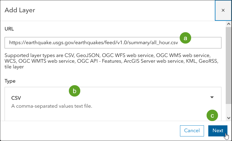
Step 3a – Paste the URL obtained in Step 2b above into the
Step 3b – Ensure the type is CSV (this should happen automatically).
Step 3c – Click Next.
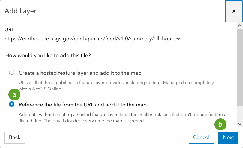
Step 4a – Add the file by referencing the file by URL. If you choose to create a hosted feature layer, a snapshot of the current status will be published and you will need to update the hosted feature layer manually.
Step 4b – Click Next.
The locations of earthquakes are read from the CSV file (which is physically located on the USGS website and referenced via its URL) and displayed on the map.
Every time the map is opened, new data will be fetched from the layer URL locations. Since a refresh interval has also been set, even when the map is not refreshed the layers will update every minute, matching the USGS update interval.

Setting a refresh interval
In the example above, the earthquake data is refreshed each time the map is opened. However you can set a specific refresh interval for the layer. In this case we know from the information posted on the USGS site that the CSV is updated every minute, so we can set the layer to refresh at 1-minute intervals to match.
To set a refresh interval, select the layer.

From the Settings (light) toolbar do the following:
Step 5a – Click Properties.
Step 5b – Scroll down and click Refresh interval.
Step 5c – Toggle Automatically refresh layer on.
Step5d – Set the refresh interval to 1 minute to match the refresh interval of the source USGS file.

The layer refresh interval is saved with the map, and updates will occur as specified wherever the map is used (in apps, embedded in websites, etc.).
Doing more
You can add the USGS GeoJSON files and GeoRSS feeds from the following locations. The workflow is the same as described above for CSV file.
More information
Note that the updates described using URL-based CSVs only occur when using lat/long locations and not when using addresses. If symbolizing on values in the CSV (using color, size, or unique values), new values and ranges not previously within the source file will not be displayed unless symbol styles are reapplied.
For more information see the following:
- CSV, TXT, and GPX files (Help)
- GeoJSON files (Help)
- Add layers (Help)
- Add layers from web (Help)

Commenting is not enabled for this article.