2024 saw the introduction of many improvements and new capabilities in ArcGIS Online and related products. Whether you’re making maps to respond to severe weather events, plan cities, increase resilience, fight wildfires, or improve your business, ArcGIS Online continues to evolve to better support your needs and activities.
It’s easy to overlook some of the changes and improvements that have occurred over the course of the past year, especially when you’re busy or don’t have time to explore all of the new capabilities. As a refresher, here’s an overview of what’s been delivered with links to additional details.
The Top picks and Other highlights are subjective, so view the entire What’s New blog article for each update (links are found in each section) to make your own picks and discover new features that you may have missed
Quick links
Use the links below to jump to sections of interest.
February 2024
Top picks
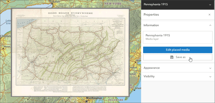
With the February 2024 update, the ability to save media layers as items is introduced. Previously, media layers could only be saved in the web map, with this update they can be saved as items and reused in other web maps. The media positioning, styling effects, and visibility settings are saved in the media layer item and layers will automatically adjust to other maps they are added to.

An Image collection explorer is introduced and is available from the Settings (light) toolbar for dynamic imagery layers. You can review the input imagery, sort by any attribute, and hover to show the footprint in your map. Filters can be applied to define an area of interest and attributes, and a slider can be used to show imagery matching a specific attribute range.
ArcGIS Data Pipelines came out of beta and became available for general use. ArcGIS Data Pipelines is a new data integration application in ArcGIS Online, offering a fast and efficient way to ingest, prepare, and maintain data. Featuring an intuitive drag and drop interface, users can connect to a variety of data sources (including external cloud databases and cloud storage), perform data preparation operations, and create hosted feature layers that can be used across the ArcGIS system.
A new capability to add features directly to a map is made possible by creating a sketch layer. When you create a sketch layer, you add sketch features to symbolize something you want to show on the map and can also add descriptive information that appears in pop-ups when sketch features are clicked. The features in a sketch layer are saved with the map and you can edit and update them at anytime.
You can now create and edit raster functions directly from Map Viewer with the Raster function editor. You can open existing raster function templates or create a new one for your analysis directly from the map.
Other highlights
You can publish your own web styles using ArcGIS Pro and use them in Map Viewer, extending the built-in styles to use your own unique symbols. The web styles can contain 2D symbols for points, lines and polygons.
Scene Viewer now integrates 3D tiles integrated mesh layers into scenes. A 3D tiles integrated mesh layer can represent built and natural environments using realistic textures and elevation information and can be used in combination with other content.
A scale threshold for aggregation is introduced, eliminating the need to duplicate layers to switch from clustering or binning and seeing the individual points.
Splash screens are added to ArcGIS Dashboards, enabling you to display information to viewers when they open a dashboard. The splash screen can offer general information, instructions, or terms of use and disclaimers.
ArcGIS Instant Apps introduces the language switcher, enabling users to choose a language from a drop-down list and view text in that language inside the app. App authors can enter translated strings for user-defined text such as the app header, details, and information panel into one or more languages.
Administrators and those with administrative privileges can now bulk delete members, transferring or deleting multiple members’ content at one time. After you select the members you wish to delete you have the option to transfer or delete their content.
All the details
What’s new in ArcGIS Online (February 2024)
All February 2024 update articles
June 2024
Top picks
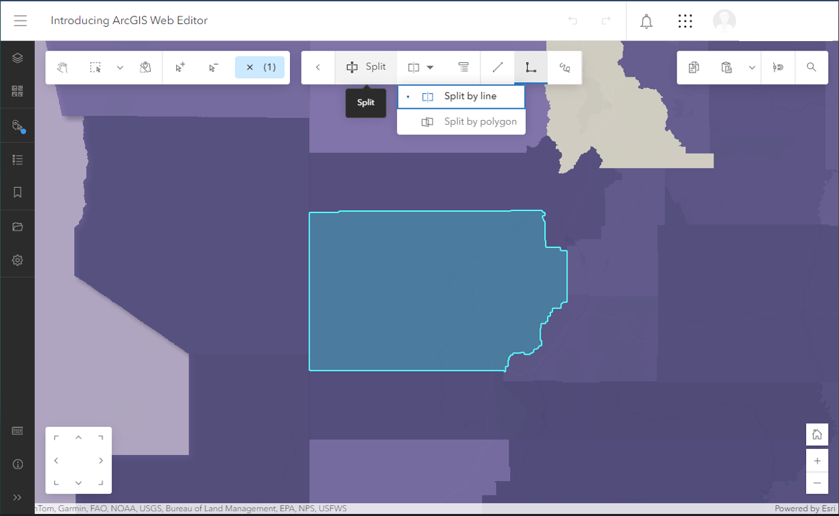
ArcGIS Web Editor is launched, a new web-based editing app that provides a focused, efficient editing experience in ArcGIS Online. Web Editor combines familiar tools, such as snapping, templates, and forms, with new capabilities. For ArcGIS Pro users, Web Editor can supplement existing editing workflows.

A recycle bin gives item owners and administrators a window of time to access and restore items that may have been deleted in error.
When customizing labels, you can now adjust the positioning of labels along lines such as streams, roads, or trails.
Attribute table enhancements are introduced, enabling you to create and edit features directly from the attribute table of a feature layer in Map Viewer. When working with table layers, you can also create and edit records directly from the table.
Other highlights
User types are updated to expand access to ArcGIS capabilities, apps, and services. These updates simplify access to ArcGIS, enabling your teams to work from anywhere and easily scale as organizational needs grow.
Map Viewer adds improved support for multidimensional imagery layers. You can now configure multidimensional imagery layers with multiple non-time dimensions. In addition, a new dimension slider can be used to animate all slices along each non-time dimension at once.
Scene Viewer includes a new time slider to control animations, with options to play, pause, and navigate between time periods.
ArcGIS Dashboards authors gain the option to select new dashboard themes or create a customized theme, supporting new color and styling options.
Credit reporting is enhanced to include details about credit consumption for storage, imagery analysis, and registered app usage. Administrators can generate credit reports on the organization’s Status tab. The credit reports show usage in different ways, including by user, by app, and by organization.
All the details
What’s new in ArcGIS Online (June 2024)
November 2024
Top picks
Multi tab views are introduced in Map Viewer, enabling users with an improved workflow experience. Tabs are used to move between open tables, charts, models, and raster function templates, making it easy to move between them to support your work.

Scene Viewer adds the ability to generate viewsheds quickly and easily, enabling users to visualize lines of sight within scenes. Viewsheds can be added by placing an observer location interactively, then adjusting the height, observer location, direction, and distance. Multiple viewsheds can be added as layers in your scene, then saved and shared with others. In addition, analysis tools are now available in Scene Viewer.
ArcGIS Experience Builder introduces a new Express mode, offering a quick and simplified app building workflow. Choose from a variety of templates (similar to those in Web AppBuilder) to begin creating a new app, then follow the streamlined workflow to complete your experience. You can add and configure additional widgets in each layout, select different themes, and preview layouts in desktop and mobile views prior to publishing.
ModelBuilder (beta) is launched. It’s an interactive canvas for building analysis workflows using the analysis tools available in Map Viewer. Models are created by chaining together data and analysis tools into workflows, where the output of one tool becomes the input for another tool. These workflows can range from routine data management tasks to complex spatial analysis.
Other highlights
Map sharing is simplified using the new Embed map tool, found on the Contents (dark) toolbar. You can quickly customize the look and feel of the map by choosing light or dark modes, toggling map elements, and configuring actions. Copy the HTML that is generated to use in a web page, such as a blog or your organization’s website.
Along with other table enhancements, Attachments can now be deleted, downloaded, updated, or viewed from within the table. You can also now add attachments using a familiar file browsing experience, or drag and drop supported files into the Attachment column.
CSS grids and flexbox layouts allow you to format pop-up content using defined rows and columns into which attributes or calculated Arcade variables can be placed. CSS grids and flexbox provide additional flexibility when you need to create more complicated layouts. Both can now be leveraged in returned text generated in Arcade elements, and can also be used within the Text element HTML editor.
Aggregation styles now support both lines and polygons in addition to points. Bins can be configured to display the density of features along with aggregated counts.
All the details
What’s new in ArcGIS Online (November 2024)
All November 2024 update articles
More information
For more information, and to stay on top of announcements and forthcoming releases, see the following:
The year ahead
There are many new capabilities and incremental improvements that will be introduced throughout 2025. You can contribute your ideas and help prioritize what’s delivered by providing feedback via ArcGIS Ideas.


Commenting is not enabled for this article.