2023 introduced many improvements and new capabilities in ArcGIS Online and related products. Whether you’re making maps to respond to severe weather events, plan cities, increase resilience, fight wildfires, or improve your business, ArcGIS Online continues to evolve to better support your needs and activities.
It’s easy to overlook some of the changes and improvements that have occurred over the course of the past year, especially when you’re busy or don’t have time to explore all of the new capabilities. As a refresher, here’s an overview of what’s been delivered with links to all the details.
The Top picks and Other highlights are subjective, so view the entire What’s New blog article (links in each section) to make your own picks and discover new features that you may have missed

Quick links
There were three updates in 2023. Use the links below to jump to sections of interest.

February 2023
Top picks
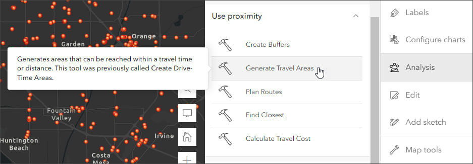
A new enhanced analysis experience with new capabilities is introduced in Map Viewer. Click Analysis from the Settings (light) toolbar to show the analysis pane where you can browse all tools or view previous analysis history.

Analysis history shows which tools have been run, their results, the parameters used, and any errors or warnings. Tools are organized by function and can be searched by name or keyword. Hover over a tool to get more information.
When you save your map, the analysis tool history is saved along with it, allowing others to view job details and reopen the tool parameters when you share the map. This provides a way for others to use the analysis that you have done and modify and extend it for their own use.
ArcGIS Image for ArcGIS Online is a complete software as a service (SaaS) extension for hosting, visualizing, analyzing, and sharing imagery. In this update, ArcGIS Image users saw 24 additional raster analysis tools added to Map Viewer.
Media layers are introduced, a new type of layer that enables you to select an image file to add to your map. Positioning tools are used to place and rotate the image to set it in the desired location. Media layers are saved with the map.
Other highlights
Support for Image symbols is introduced, you can upload .gif, .jpg, and .png images to use as symbols when styling your layer or creating a sketch in Map Viewer.
Groups in legends can now be configured to help add detail and organize the map legend when styling a feature layer by type using unique symbols.
Scene Viewer adds feature snapping when measuring.
ArcGIS Instant Apps includes updates and enhancements to Insets, Interactive Legend, and Slider.
Query performance can be improved with user definable attribute indexes when queries search for words or phrases in string fields.
Item view counts are added to the collection of organization reports that administrators can run and schedule.
All the details
What’s new in ArcGIS Online (February 2023)
All February 2023 update articles

June 2023
Top picks
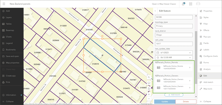
Support for editing related records in Map Viewer was added by configuring forms for attribute editing. Related tables are displayed in the form (outlined in the green box shown below) and can be opened for editing, displaying the configured fields from the related table(s).

Using the form, attribute values for the related records can be updated and added as needed during feature editing.
An improved add layer experience in Map Viewer was introduced, providing more context and information about layers, basemaps, and other content making it easier to learn more about content when adding layers to your map.
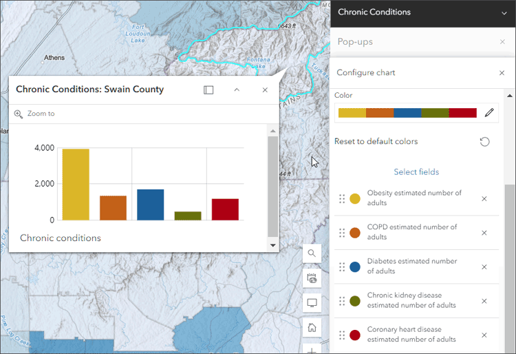
Pop-ups were enhanced with redesigned feature pagination and menu buttons, plus support for color ramps with matching tooltips for charts.
Group layers were enhanced with the introduction of exclusive visibility. This feature enables the display of only one layer without having to hide each of the other layers. This is particularly useful when a group layer contains a large number of layers.
Multidimensional sliders were introduced for image layers containing multiple slices of data that you want to explore. Configuring multidimensional settings allows you to visualize a particular slice within a multidimensional imagery layer and specify which slices are displayed in the map.
Other highlights
New analysis tools and improvements to existing tools are introduced, including a set of raster analysis tools that expands the capabilities of Map Viewer for hydrological analysis.
Raster functions were added to Map Viewer, providing additional analysis and visualization options. Raster function templates are combinations of raster functions that are used to create a specific visualization or analysis that can be repeated and shared.
Scene Viewer gets enhanced visuals so you can show water reflections, better shading, and sharper labeling. New 3D basemaps are released in beta with worldwide coverage, containing buildings, trees, places, and billboarded labels, is available in the Scene Viewer basemap gallery. These features are published from the OpenStreetMap (OSM) Daylight Distribution, and are updated regularly.
ArcGIS Dashboards adds mobile dashboard views to you can configure a single dashboard to have two views in ArcGIS Dashboards. Each view is optimized for viewing on either desktop or mobile devices. The mobile view can include the same elements as your desktop view, or new elements with different configurations, providing fine-tuning capabilities for the target device or user.
ArcGIS Experience Builder adds new templates and widgets, including Swipe and a basemap gallery widget.
A new update data workflow is introduced, delivering a more intuitive display of options and combining some separate workflows into single workflows.
Data Pipelines is introduced in beta, facilitating the process of bringing in disparate vector or tabular data and processing it using a suite of data preparation tools to convert it to a useful format.
All the details
What’s new in ArcGIS Online (June 2023)

October 2023
Top picks
Pop-up chart element improvements deliver the ability toselect custom colors and color ramps. You can use this new capability to configure charts to use the same colors which are defined in the data layer styling, or apply custom colors to focus on specific chart data.

Charts created from hosted feature layers or tables can now be configured with box plots. Box plots allow you to visualize and compare the distribution and central tendency of numeric values through their quartiles.
Map authors can now choose a specific time zone for their maps, ensuring all pop-ups and attribute data are consistently presented in the desired time zone rather than being influenced by the end user’s browser or mobile device.
Other highlights
Administrators can now enforce multifactor authentication across their organization to ensure that members with ArcGIS logins are in compliance with security policies when signing in to ArcGIS Online.
Oriented imagery support is added to Map Viewer, supporting viewing and managing oriented imagery layers using the oriented imagery viewer. When added to the map, each point in an oriented imagery layer indicates the camera location where an image was acquired.
New raster functions are introduced in Map Viewer, including the ability to display a preview of the result. Using previews you can modify the parameters before running the analysis, ensuring you obtain the expected result.
Scene Viewer introduces presentation mode. In this mode, all but the essential navigation tools and a minimized slide ribbon are displayed, applying emphasis to the scene content.
ArcGIS Instant Apps add a language switcher, which can be used to allow users to choose a language from a drop-down list and view text in that language inside your web app. App authors can enter translated strings for user-defined text such as the app header, details, and information panel into one or more languages.
ArcGIS Dashboards adds support for web scenes, improved mobile view actions, category selectors, and new map selection tools.
ArcGIS Experience Builder adds a new analysis widget, allowing you to add spatial analysis and geoprocessing tools to any app, delivering full analysis capabilities to users.
All the details
What’s new in ArcGIS Online (June 2023)

More information
For more information, and to stay on top of announcements and forthcoming releases, see the following:
The year ahead
There are many new capabilities and incremental improvements that will be introduced throughout 2024. You can contribute your ideas and help prioritize what’s delivered by providing feedback via ArcGIS Ideas.


Commenting is not enabled for this article.