2020 has been a busy development year for ArcGIS Online and related products, with many improvements and new capabilities. Whether you’re making maps to mitigate COVID-19, fight wildfires, plan cities, protect ecosystems, improve your business, or tell stories, ArcGIS Online continues to evolve to better support your needs and activities.
It’s easy to overlook some of the changes and improvements in a release, especially when you’re busy or don’t have time to explore new capabilities. As a refresher, here’s an overview of what’s been delivered with links to all the details. The Top picks and Other highlights are subjective, so view the entire release blog article to make your own picks and discover new features that you may have missed.
Quick links
Use the links below to jump to a specific release.

March 2020
Top picks
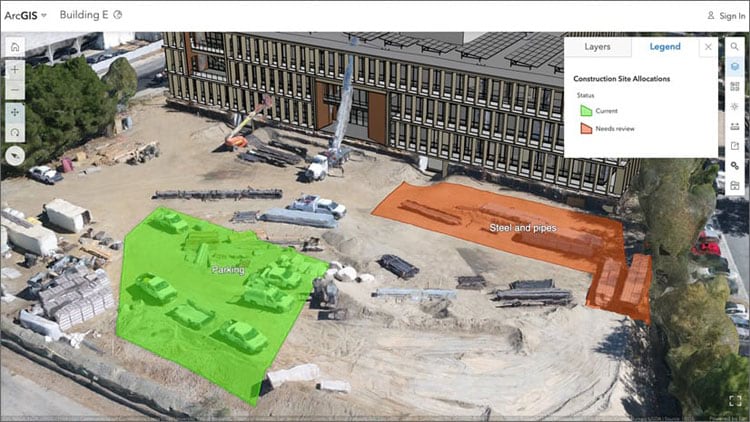
The ability to drape feature layers onto integrated mesh scene layers for better 3D visualization was added. This enables you to gather a recent 3D snapshot of an area of interest with Drone2Map for ArcGIS or SiteScan as an integrated mesh scene layer and easily mark locations with points, lines and polygons, as shown in the construction scene below.

In addition, the Building explorer tool received improved filtering options for building scene layers. Using a new filter you can choose which construction phase to show. For example, you can choose a specific construction phase to display all the components created during the phase and before.
Other highlights
The user profile and settings experience was redesigned, allowing you to showcase yourself and your content through the refreshed user profile page.
Streamlined Edit settings on hosted feature layers and hosted feature layer views were introduced, allowing you to control the types of edits others can make to your layer, including allowing or disallowing edits to feature geometries.
New OpenStreetMap layers are now hosted in ArcGIS Online and available in ArcGIS Living Atlas. A new OSM light gray canvas style is also now available, and is designed to match Esri’s Light Gray Canvas using thinned content from the full OSM data.
World Terrestrial Ecosystems is the first-of-its-kind effort to characterize and map global terrestrial ecosystems at a much finer spatial resolution. The layer uses land cover as input to generate 431 unique terrestrial ecosystems on Earth.
ArcGIS StoryMaps adds support for map actions and a navigation bar. A new guided tour and a credits block are introduced, and improvements made to sidecar.
ArcGIS Experience Builder is introduced. Launch ArcGIS Experience Builder from the app launcher or sign in at the Experience Builder landing page. You can also access Experience Builder from the Create menu on the content page as another way to create apps.
All the details
What’s new in ArcGIS Online (March 2020)
All March 2020 release articles

June 2020
Top picks
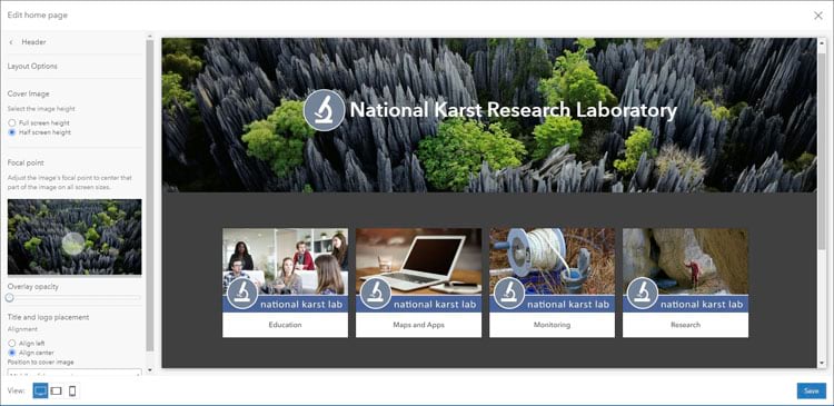
A new home page editor is introduced, letting you quickly create a a modern and professional-looking home page that reflects your organization’s branding and mission. Configure your home page using ready-to-use components and add item galleries and text blocks to showcase the content that is important to your community.

ArcGIS Notebooks is no longer in beta and is available for all ArcGIS Online organizations. ArcGIS Notebooks provides a Jupyter notebook experience within ArcGIS Online to create, share, and run administrative, data management, and spatial data science workflows.
Other highlights
A new configuration experience is announced for some ArcGIS Configurable Apps, including Nearby, Minimalist, Zone Lookup, and Attachment Viewer. These now include an express setup that presents a streamlined way to go from your map to an app in just a few clicks. A full setup option is also available for those wanting more detailed configuration options.
Administrators can create detailed reports of their ArcGIS Online organization’s members and items. These asynchronous reports can be exported for further review and analysis and are saved as items in your organization for future reference.
Shaded Relief is supported on imagery layers representing elevation data. The Shaded Relief renderer generates a colorized representation of the terrain by applying a color ramp to a hillshaded elevation layer using a traditional or multidirectional hillshade.
If an organization is verified, public items that are marked as authoritative display the organization name as the item owner. Clicking the item owner link for public authoritative items shared by verified organizations now displays a pop-up with information about the organization and links to its Home page and gallery.
World Imagery Firefly has been enhanced using bumpification – a technique and style that includes terrain to accentuate and add elevation context to imagery. Bumpification applies a topographic texture to imagery at broad scales to convey the tactile surface of the earth that isn’t necessarily apparent in imagery alone.
Satellite (VIIRS) Thermal Hotspots and Fire Activity is a new layer which presents the most frequently updated and most detailed global remotely sensed wildfire information from VIIRS satellites for the last seven days. This layer is updated hourly using the aggregated live feed methodology. Fire points in the layer are generally available within 3 ¼ hours after detection by the VIIRS satellite.
The new ArcGIS Solutions app is now available in the App Launcher for all ArcGIS Online users making it easy to deploy solutions in your organization. At this release the app includes more than 25 solutions for State and Local Government, Conservation, Public Safety, Utilities, Defense, and Business ArcGIS users.
All the details
What’s new in ArcGIS Online (June 2020)
All June 2020 release articles

September 2020
Top picks
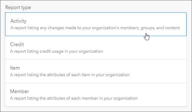
Default administrators can now create two new types of detailed reports: activity reports and credit reports. These asynchronous reports can be exported for further analysis, and are saved as items in your organization for future reference.

When configuring the home page, organization administrators can now include link blocks to help members and visitors discover more content. In addition, the number of content blocks—text, galleries, and links—you can include in the home page body has increased to 15 and is no longer limited to block type.
Using new page visibility settings, organizations can specify navigation bar access (tab visibility) for the main website pages. These tabs are seen across the top of the organization home page: Gallery, Map, Scene, and Groups.
Other highlights
Media Map, one of the configurable apps, is updated to include express and full configuration experiences.
When sharing an editable hosted feature layer or feature layer view with the public, you must now turn on a new setting to designate the layer for public data collection. The new setting prevents editable layers from being unintentionally shared with the public, which can result in data loss and data integrity concerns.
The Wildfire Public Information Map has been updated. The application is hosted by the Esri Disaster Response Program and uses Living Atlas live feeds to provide current wildfire incidents and perimeters, along with satellite (MODIS and VIIRS) thermal hotspot locations, smoke forecast, and weather watches and warnings.
Air Quality Aware is the latest in a series of easy-to-use apps that simplify access to environmental and demographic information. Air Quality Aware is intended to provide information about the current air quality conditions in the United States, along with the potential human health impacts.
Recent Conditions in Air Quality (PM2.5) shows the latest values for global air quality (PM2.5) from ground-based monitoring stations. The source is the OpenAQ community which reports measured concentrations on a global scale by aggregating station data from national networks of air quality.
ArcGIS Hub introduces new group-based row visibility options let you control which rows of content appear for different audiences who visit your sites. This feature provides new and powerful flexibility as one site can serve many audiences—share something with everyone, or keep content private and share it only to your core team, or to a supporting team.
ArcGIS for IoT is renamed ArcGIS Velocity.
All the details
What’s new in ArcGIS Online (September 2020)
All September 2020 release articles

December 2020
Top picks
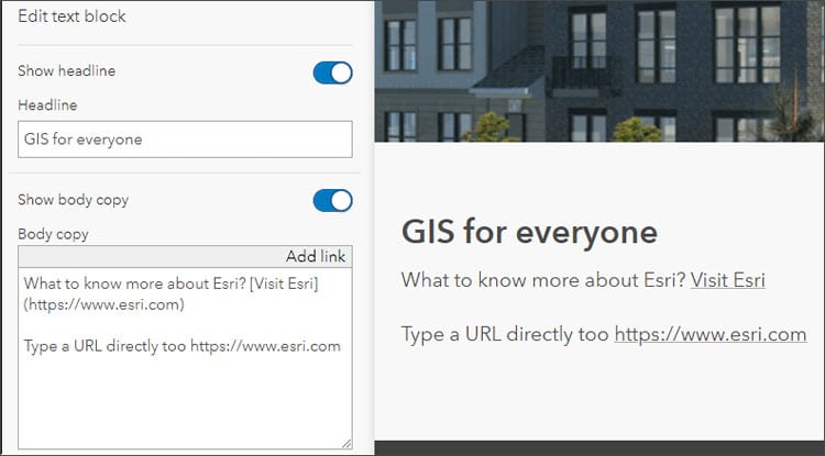
The home page configuration experience has been enhanced. Organization administrators can now include website and email links in body text and in item gallery summaries using markdown.

When home page item galleries are configured, you can now display specific item types, for example, maps, layers, or apps. When configuring an item gallery, the configuration panel now shows additional information about the shared state of the group and items inside it.
Member profiles have been updated making it easy to showcase your content and yourself. You can now control which items are listed in the item galleries linked to your profile. Use the item picker to select the items you want to display in your profile gallery, then order the items by dragging and dropping them in place.
Other highlights
A new configuration experience is available for Category Gallery and 3D Viewer (formerly named Scene with Inset Map). Build your apps using the express setup or configure them using the full setup.
ArcGIS Notebooks now has a new and improved home page experience, letting you have a comprehensive view of all of the notebooks you’ve created, notebooks shared with you within your organization, and curated notebook samples that are available for you to quickly start your own automation and analysis workflows. A new notebook search feature lets you quickly find the notebooks that you are looking for by entering the notebook name.
If you enable attribute edits on a hosted feature layer or hosted feature layer view, you can further control edits by enabling or disabling editing on individual fields. The toggle can be found in the feature layer Data tab by selecting Fields, then editing the setting.
World Imagery Wayback app adds swipe capabilities, making it easy to compare selected imagery.
On December 10, 2020, ACS released the newest data values for their 5-year estimates. Within days of that release, existing ArcGIS Living Atlas ACS layers were updated with the newest 2015-2019 data. Along with the updated layers, a subset of 2010-2014 layers were added to Living Atlas to allow for comparison over time for many ACS topics.
All the details
What’s new in ArcGIS Online (December 2020)
All December 2020 release articles

More information
For more information, and to stay on top of announcements and forthcoming releases, see the following:
The year ahead
There are many incremental improvements and new capabilities that will be introduced throughout 2021. You can contribute your ideas and help prioritize what’s delivered by providing feedback via ArcGIS Ideas.

Article Discussion: