2019 has been a busy development year for ArcGIS Online and related products, with many improvements and new capabilities. Whether you are making maps to monitor climate, fight fires, plan cities, protect ecosystems, improve your business, or tell stories, ArcGIS Online continues to evolve to better support your needs and activities.
Many of the improvements and additions are the result of community feedback, obtained from many sources. These include Esri Technical Support, Esri Training participants, MOOC program students, Esri Professional Services and Enterprise Advantage Program subscribers, Esri partners, GeoNet, ArcGIS Ideas, conferences and meetings, account managers and solution engineers, emails you’ve sent, and other communications. Your feedback is continually compiled, and frames each release and the road ahead.
It’s easy to overlook some of the changes and improvements in a release, especially when you’re busy or don’t have time to explore new capabilities. As a refresher, here’s an overview of what’s been delivered, with links to all the details. The Top pick and Other picks are subjective, so view the entire release blog article to make your own picks, and discover new features that you may have missed.
March 2019
Top Pick
Two new configurable were introduced, one for web maps and the other for group-based content. Configurable apps use templates that you can configure easily, helping you publish apps quickly for a variety of users and workflows.
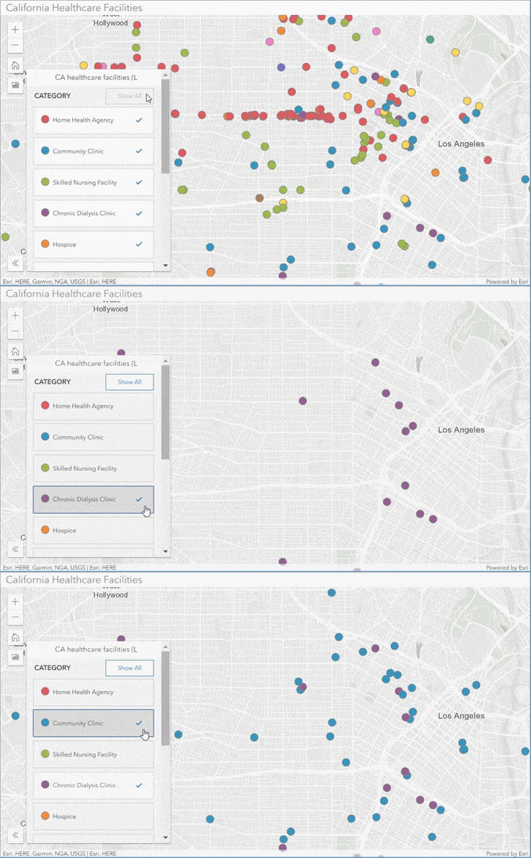
Interactive Legend gives you the ability to explore feature layers in the map by interacting with the legend. Viewers can explore the map visually or select legend categories that are of the most interest to them.

Use Category Gallery, a group-based configurable app, to build a gallery of maps, apps, and layers that can be filtered based on category. Categories may come from those established in the organization, or group content can be categorized uniquely into themes or topics of interest, then discovered via the gallery category filter. View the Category Gallery item page for more information.
Other picks
Georeferenced photos can now be displayed on a map by uploading them via a .zip file. A hosted feature layer is created using the lat/long coordinates from the photo, with links to view them. See Publish photos with locations for more information.
Public Safety and Government symbol sets were updated for the Map Viewer.
As an alternative to uploading an image, you can now create a custom thumbnail for your layer or map item by interacting with a map using Create Thumbnail Using Map. You can choose a different basemap or change the zoom and location to get the desired results. See Thumbnail image for more information.
Organizations participating in a distributed collaboration can now share hosted feature layer views as copies between ArcGIS Online and ArcGIS Enterprise portals. When an organization receives collaborated content, a badge is displayed on the item page to indicate that the item was received from another portal.
Generate Tessellations was added to the spatial analysis tools, enabling you to create bins over a study area determined by extent, shape, and size. Tessellations are useful for splitting geography into regular shapes that support thematic mapping, and enable you to see patterns.
The OpenStreetMap vector basemap maintained and hosted by Esri, is released. The OpenStreetMap basemap can be accessed as one of the standard basemaps in the basemap gallery, and small areas can be exported for offline use.
All the details
What’s new in ArcGIS Online (March 2019)
All March 2019 release articles
June 2019
Top pick
You can now customize the style of vector tile layers, including those in basemaps, directly in Map Viewer. Hover over any vector tile layer and click Change Style to open the Vector Tile Style Editor.
Vector tiles enable dynamic cartography and provide the flexibility to create your own layer or basemap styles. Vector tile layers retain the underlying data on the server, and the rendering is applied client-side via a style file. By creating your own style, the same data can be rendered in a variety of different ways, as shown below in this comparison of Esri vector tile basemaps. You can view other examples in the Creative Vector Tile Layers group.

The Vector Tile Style Editor app can also be opened directly from its ArcGIS Online item page. Use the Vector Tile Style Editor to choose from a gallery of Esri vector tile basemaps and layers to create your own basemap style.
Other picks
ArcGIS QuickCapture was introduced, it’s a new mobile application that allows you to capture field observations with the single tap of a button. QuickCapture is specifically designed to help you capture field observations fast. and is ideal for at-speed data collection workflows.
ArcGIS Living Atlas adds several new vector basemaps; Navigation (Dark Mode), National Geographic Style, Community Map, Watercolour, OpenStreetMap (Esri Street style), and OpenStreetMap (Esri Imagery Hybrid style).
Powered by the Living Atlas, Esri Maps for Public Policy is a free resource for policy makers to actively engage in community decision making. Esri Maps for Public Policy delivers ready-to-use maps from curated datasets that help you learn more about social equity and health, economic opportunity, transportation and infrastructure, resilience and sustainability, environment and natural resources, and public safety in your community.
Two new configurable apps were introduced. Attachment Viewer allows you to provide an immersive experience for viewing feature layer attachments. The app is especially useful for viewing attachments on layers created by Collector for ArcGIS, Survey123, QuickCapture, and more. Zone Lookup locates boundaries, zones, or districts which intersect a specific location or address. Users of this app can learn more about a location and features of interest in the surrounding area.
Administrators get new capabilities with improvements to simplify the member invitation process by configuring new member defaults, performing bulk member management tasks, and new options for creating groups within the organization. A new set of administrative privileges can also be assigned through custom roles.
All the details
What’s new in ArcGIS Online (June 2019)
All June 2019 release articles
October 2019
Top pick
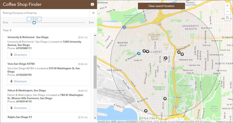
Nearby was introduced, a new configurable app that lets users enter an address and search radius to find nearby locations. By grouping the results by layer, app authors can configure the app to answer detailed questions. For example, a user could search for nearby schools and see them grouped by the school type, including middle schools, elementary schools, and universities. Nearby apps can also be configured to answer questions such as, Where is the nearest coffee shop?

Other configurable apps have been updated and improved. Attachment Viewer gets a new map layout option, Media Map adds an interactive time slider and also adds a swipe widget, Category Gallery now includes a sign in button and the ability to configure the filter pane to open by default.
Other picks
New online analysis enhancements are delivered. Create Drive-Time Areas adds three new parameters to improve the tool’s capabilities. Connect Origins to Destinations adds new parameters, and enhanced capabilities to create multiple types of connections. Enrich Layer is enhanced to allow users to select variables from different datasets, or all available datasets for specific countries.
Scene Viewer lets you author, view, and share 3D scenes. With this release, Scene Viewer adds visibility range control, pop-ups on point cloud scene layers. a new lighting and shading model, and performance enhancements.
Arcade, an expression language that can be used across the platform, adds several new functions; GroupBy, DistanceGeodetic, FeatureSetByRelationship, and FeatureSetByPortalItem.
Two new apps available from the Apps tab at the Living Atlas website were featured. Sea Ice Aware displays the monthly mean sea ice extent for the Arctic and Antarctic along with the historical median extent. Additionally, graphs are used to visualize the minimum and maximum extent for each year. Hurricane Aware provides information about the potential impacts of tropical storms in the United States. Numerous other layers are updated, and a new collection of hands on lessons for Living Atlas are now available on Learn ArcGIS.
All the details
What’s new in ArcGIS Online (October 2019)
All October 2019 release articles
December 2019
Top pick
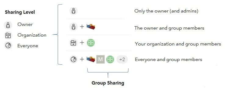
Sharing items in ArcGIS Online has been improved. On your content page, you can quickly see who can access your items and the groups with which they have been shared.

The changes enable you to clearly see sharing levels (Owner, Organization, Everyone), as well as the specific groups with which you have shared content. Group designations, such as Featured Content and Open Data groups, are also clearly identified.
Other picks
A new setting allows you to display custom information banners at the top and bottom of your site to inform members about your organization’s status and content. Access notices can be configured to display a notice of terms for users who access your site.
The organization settings experience has been improved with a new design, the ability to search for the setting you want, and discovery of individual settings. Administrators can more easily navigate the organization settings tab by searching for a setting, or using the side navigation links. In addition, changes are now saved automatically. For more information, see New features in organization settings.
The next generation Map Viewer is now available in beta. Access it from your ArcGIS Online organization through the app launcher, or when opening map or layer items. For more information, see the Map Viewer Beta space on GeoNet.
The Living Atlas Wayback app has been enhanced to include better sharing capabilities, configuration options, and an improved mobile experience. For more information, see Wayback app enhancements. This release also includes numerous updates to other content, such as elevation, environment, hydrography, and demographics, including updates to Living Atlas ACS layers.
All the details
What’s new in ArcGIS Online (December 2019)
All December 2019 release articles
The year ahead
There are many incremental improvements, as well as major new capabilities, that will be introduced throughout 2020. You can contribute and prioritize what’s delivered by providing feedback via ArcGIS Ideas or the ArcGIS Online space on GeoNet. Stay tuned to the ArcGIS Online blog and GeoNet for announcements, and the latest information about upcoming releases.

Commenting is not enabled for this article.