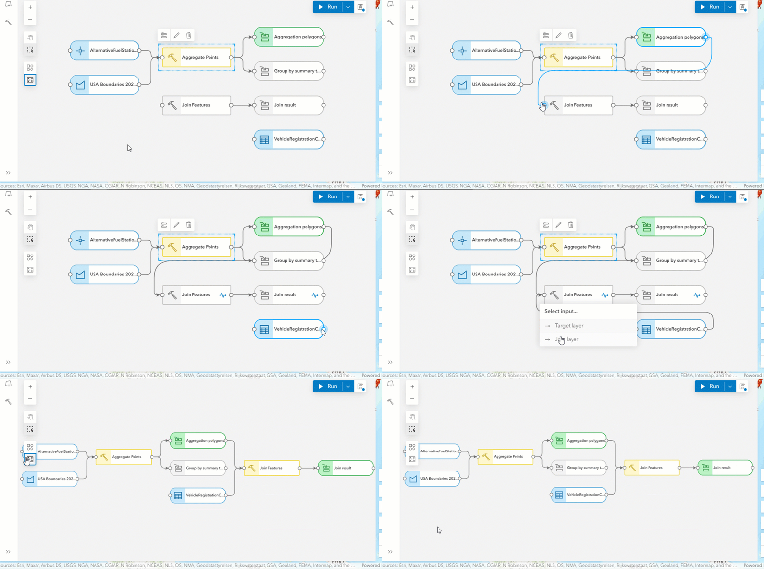
Are you a GIS analyst, business analyst, or instructor using ArcGIS Online’s analysis tools to solve spatial problems or integrate location intelligence into your data analysis? We have exciting news: ModelBuilder is coming to ArcGIS Online in the November 2024 update! Designed for users who prefer a no-code approach, ModelBuilder helps to streamline your workflows using intuitive visual diagrams directly within Map Viewer.
What is ModelBuilder?
ModelBuilder allows you to build models that chain analysis tools and data together, where the output of one tool becomes the input for another. Models are used to create multi-step workflows, ranging from routine tasks like managing spatial data to complex analysis workflows.

With ModelBuilder, you can:
- Automate Analysis Workflows: Build models by adding and connecting analysis tools and data without writing code. Once a model is built, you can run it repeatedly to streamline tasks and reduce errors.
- Document and Communicate: A model provides a visual, step-by-step interface, allowing users to see exactly how it was built. You can see the specific parameters applied for every tool used in ModelBuilder and the input and output for each step.
- Improve performance: During model execution, only the temporary intermediate datasets are generated by each tool before the final output, eliminating the performance bottlenecks of creating an output hosted feature layer after every tool.
Check out the video below to see ModelBuilder in action.
Join the ModelBuilder Early Adopter Program
ModelBuilder is in beta, and we invite you to join the Early Adopter Community (EAC). Here, you can share your experiences and access additional resources, including a getting started tutorial, FAQs, and other latest announcements on features and functionalities.
If you have any questions, suggestions, or feedback, please post in the ModelBuilder EAC forums. Our team is happy to help you out!
Get started with ModelBuilder
You can access ModelBuilder from the Analysis pane within Map Viewer.
To use ModelBuilder, you will need an ArcGIS Online subscription account with either Professional or Professional Plus user types. To build a model, users must connect to an analysis session that provides compute resources in the cloud to power ModelBuilder operations such as authoring and running a model. Credits are charged based on how long you are connected to the analysis session, similar to session-based credit consumption in ArcGIS Data Pipelines and ArcGIS Notebooks.
You can track the number of credits consumed during your ModelBuilder session directly in the ModelBuilder pane and at the top of the Map Viewer. For more details on how and when ModelBuilder consumes credits, please refer to the ModelBuilder FAQ on licensing requirements available in the ModelBuilder Early Adopter Community.
Build models by integrating data and tools
ModelBuilder’s interactive authoring environment simplifies the creation and execution of models. You can visually connect data and tools to form models. For instance, draw lines to designate input datasets for selected tools, or use the auto-layout option to automatically arrange model components, making the workflow more understandable.
Validation occurs automatically during the authoring process, ensuring that all model elements—including data sources and tool parameters are in a “ready-to-run” state. Once your model is complete, you can run the model. This streamlined approach not only boosts efficiency but also enhances the transparency and reproducibility of your spatial analyses.

Input Data
ModelBuilder supports feature layers and hosted tables as input data. Users can easily select layers directly from the web map or browse available data sources, including ArcGIS Living Atlas. When adding layers from the web map, you can select a subset of data by applying an attribute filter using Map Viewer’s filter option. This attribute filter will carry over to the model tool input, ensuring that only the features that meet the selection criteria are used as inputs in the model.
Tools
Most feature analysis tools available in Map Viewer are supported for inclusion in a model, with additional tools expected in future releases. For a complete list of the tools available in the initial beta release of ModelBuilder, please refer to the FAQ section in the ModelBuilder Early Adopter Community. This resource will keep you informed about the current capabilities and upcoming enhancements.
Model Outputs
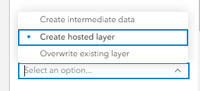
By default, each tool in a model generates temporary, intermediate data outputs that are essential for the workflow, serving as inputs for subsequent tools. These datasets are not intended for long-term storage and are typically deleted after the model finishes running. Using intermediate data helps to optimize performance and avoids creating unnecessary hosted layers.
To preserve intermediate data, such as the final model results, you can choose the “Create hosted layer” option in the tool dialog. This option enables you to save the output as a hosted feature layer within your organization, so you can access and share it after the model has completed running.
Additionally, you can overwrite existing result layers. This flexibility enables you to avoid generating new output files with each run, saving time and storage space while ensuring that the latest outputs reflect any changes made to the model.

Integrated with Analysis History
Analysis history tracks analysis runs in the web map. When a model is run, an entry is added in the web map’s History pane. You can use the analysis history to view details about the model run, access output datasets, and view any warning or error messages.
We want your feedback!
The Esri web analysis team is very excited to introduce ModelBuilder (beta) in ArcGIS Online. Join the Early Adopter Community to post your questions, share your experiences, and provide feedback in our forums. We are eager to hear your thoughts about the new ModelBuilder capability and your analysis experience in ArcGIS Online.
Happy analysis!

Interested to know if this is on the roadmap for Enterprise portal?