NAIP imagery has long been available in ArcGIS Living Atlas as a dynamic image service, enabling image analysis on the 4-band source imagery dating back to 2010. However, for those who wish to leverage the imagery for visualization, the latest NAIP imagery has been optimized for display quality and performance in the form of a new tile layer.
National Agriculture Imagery Program (NAIP)
The National Agriculture Imagery Program (NAIP) features recent high-resolution aerial imagery from the USDA Farm Services Agency. NAIP imagery collection occurs on an annual basis during the agricultural growing season in the continental United States. Approximately half of the US is collected each year and each state is typically collected every other year. The NAIP program aims to make the imagery available to governmental agencies and to the public within a year of collection. The spatial resolution of the imagery has historically ranged from 0.6 to 1.0 meters. However, starting with 2018, the USDA announced that all subsequent years of NAIP imagery will be provided at 0.6-meters resolution.
Providing fast and simple access
At a high level, our recipe for providing fast and simple access to NAIP imagery is really quite simple: 1) start with the latest NAIP imagery, enough to cover the continental US; 2) apply some visual enhancements to improve the aesthetic quality of each state; 3) bake the imagery using a pre-defined tiling scheme; 4) publish the imagery as a tile layer, providing everyone fast and simple access to the imagery via pre-rendered raster tiles. Not sure what we just cooked up? It may help to think of it as a ‘Natural Color NAIP Imagery Basemap’. Still unsure? Here is some additional information regarding ArcGIS Online tile layers.
The NAIP Imagery tile layer will be updated each year, as the latest imagery is received and processed. In other words, this layer will continually provide enhanced coverage of the latest NAIP imagery. While it is currently composed of 2017 and 2018 coverage, when the 2019 imagery becomes available, the layer will be updated accordingly.

Icing on the cake
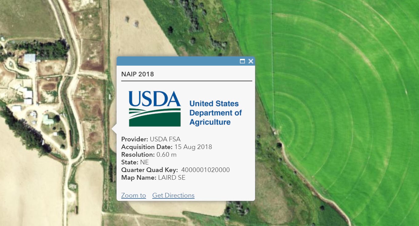
To complete this new experience, we are also providing a metadata overlay. Yes, an overlay of data about data. Use the NAIP Imagery Metadata layer in conjunction with the NAIP Imagery tile layer to interrogate the imagery via a point-and-click map pop-up. Simply click on the map and the pop-up unveils additional information about the imagery at your location of interest, including the date the imagery was captured. To make things even easier, you can use this NAIP Imagery with Metadata web map, also found in the Living Atlas, which has both the imagery and metadata pre-loaded and ready to use.
For the avoidance of doubt, in order to support image analysis in your workflows, we will continue to update and maintain the USA NAIP image service and the corresponding Living Atlas layers: Natural Color, Color Infrared, and NDVI.
In case you missed them, here are the links to the new layers and items:
NAIP Imagery with Metadata (web map including both new layers above)
Thanks to the imagery production team for their efforts in getting this out the door and into the hands our our users.
Special shout out to Atif Zafar for all of his handy and diligent work. Thanks Atif!

Is there a way to access older NAIP imagery through the Living Atlas, or does it only provide the most recent imagery? We are mostly interested in NAIP imagery over shallow water coastal areas and water clarity usually determines the usefulness of the imagery. I am trying to determine if there is a straightforward way to cycle through and select from mulitple iterations of the biennial NAIP imagery. Thanks – Tom
Hi Tom, you can use the Living Atlas NAIP image layers noted in this article to cycle through the years back to 2010.
Natural Color – https://www.arcgis.com/home/item.html?id=3f8d2d3828f24c00ae279db4af26d566
Color Infrared – https://www.arcgis.com/home/item.html?id=e4da3b6720f545aeaaf3fe8141da1e21
NDVI – https://www.arcgis.com/home/item.html?id=aa9c87d6f17b452296252bd75005f6a4
NOTE: If you are working in Online, you will likely want to use the ‘Image Filter’ capability available for image layers in Map Viewer Classic (the new Map Viewer does not yet have the ‘Image filter’ capability).
Hope this helps! – Rob
Is the metadata layer the same for both NAIP Imagery and NAIP Imagery Natural Color? If not, is there a metadata layer for Natural Color?