
The ArcGIS Roads and Highways and ArcGIS Pipeline Referencing extensions include a variety of new and enhanced features for the ArcGIS Pro 3.4 and ArcGIS Enterprise 11.4 releases.
- Summary
- New Capabilities in ArcGIS Pro
- New Capabilities in ArcGIS Enterprise
- Address Data Management Support
- Resources
Summary
Here’s a quick overview of new functionality available in ArcGIS Roads and Highways and ArcGIS Pipeline Referencing extensions for ArcGIS Pro and ArcGIS Enterprise.
New Features in ArcGIS Pro
- Event Editing options: Ability to add events to the primary route using the Add Point and Line event tools.
- Advanced Table Editing: Enhanced attribute table editing options for event attributes.
- Process Edits tool: A new tool to automatically execute post-route editing processes, such as applying event behaviors and generating intersections and events.
- Point support: Point support in all dynamic segmentation operations.
- Roads and Highways and Address Data Management Integration: New capabilities for maintaining address and roadway characteristics together with the Address Data Management solution.
New Features in ArcGIS Enterprise
- LRS Widget in Experience Builder: A new LRS widget allows users to dynamically segment data and view the results as either a table or a straight-line diagram.
- Updated Template Applications: Template applications for deploying LRS Experience Builder widgets have been updated to incorporate the new widget and improve the time configuration experience.
- Enhanced Usability: A series of enhancements to improve usability for data maintainers.
- New Workflow: A new workflow for transforming linear-referenced event data into reports and dashboards for decision-making.
- Analysis and Visualization: New analysis and visualization capabilities for web application users of all types.
ArcGIS Pro Capabilities
The ArcGIS Pro 3.4 release includes a variety of new tools and capabilities around data product creation for reporting, dynamic segmentation, event editing, and streamlining common post-route editing tasks.
LRS data products for reporting
As the use of LRS data continues to grow within organizations that are utilizing Roads and Highways and Pipeline Referencing, the need to leverage this data for decision-making and compliance reporting has grown as well. New tools in this release support the creation of LRS data products that can be utilized to create reports, dashboards, and other visualizations. Templates reference LRS events and other layers and how they are to be summarized for the desired reporting product.
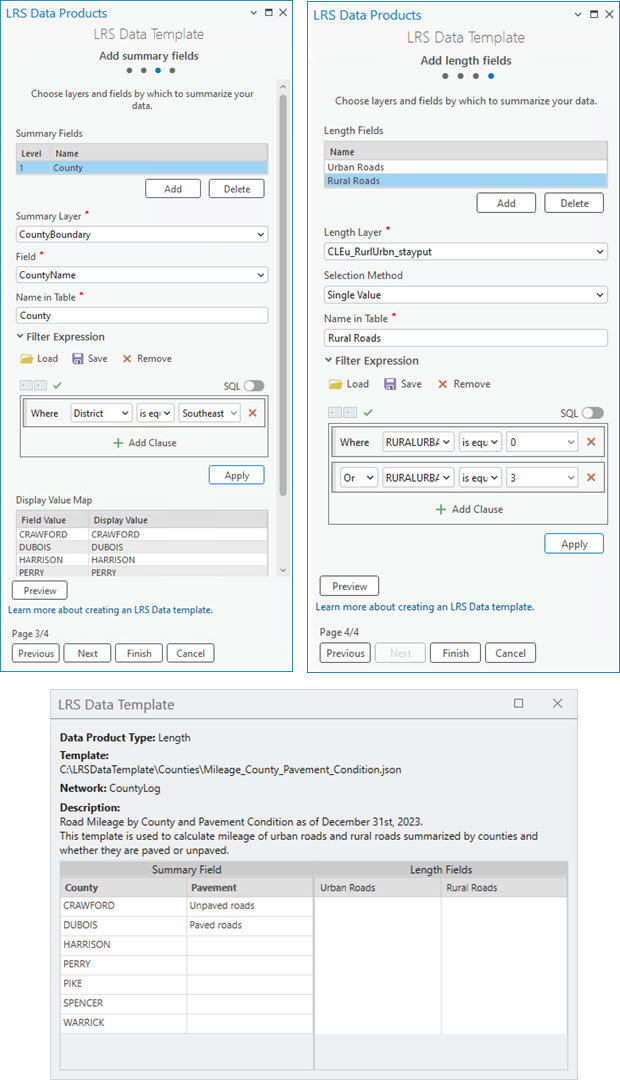
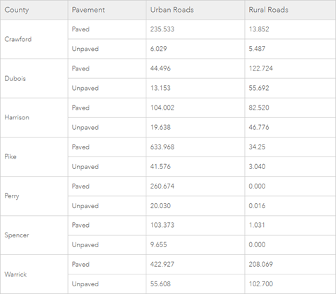
The template can then be used within the new Generate LRS Data Products geoprocessing tool either in an ad hoc manner or automated to execute on a regular interval (monthly, quarterly, annually, etc.) to transform the LRS data into an output that is ready for use in ArcGIS Pro, ArcGIS Dashboards, PowerBI, Crystal Reports, or other reporting applications.
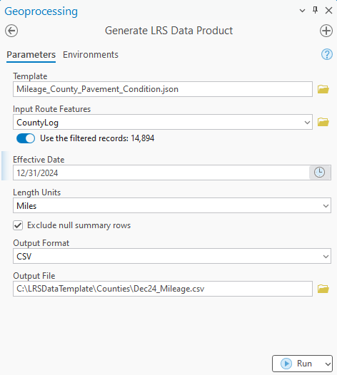
The template-based approach allows the desired data product to be configured once and then be executed using the geoprocessing tool (or via python scripting) as often as needed, only changing the parameters, LRS data and route selection, that might change time when the tool is run. At this release, length (or mileage) type reports are supported. Future releases will include support for other common report types such as segment, log, and count reports.
Point event support in dynamic segmentation tools
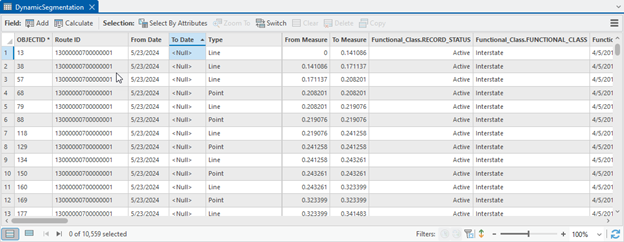
Dynamic segmentation operations within ArcGIS Pipeline Referencing and ArcGIS Roads and Highways now support including point events alongside line events. This allows users to include line and point event data in a single data output and the ability to edit characteristics for both event types in a single experience within ArcGIS Pro. This enhancement is available within the Overlay Events geoprocessing tool as well as the Dynamic Segmentation tool within ArcGIS Pro.
Automating data maintenance for LRS features
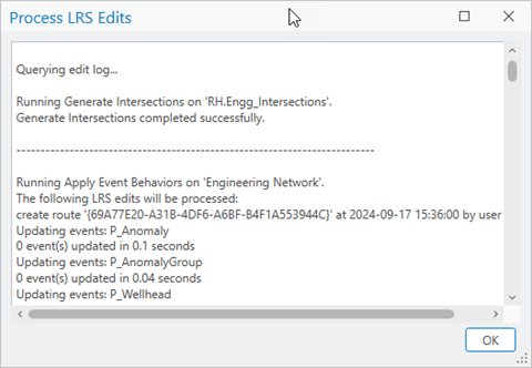
Depending on the configuration of the LRS, data editors may need to run up to 4 different geoprocessing tools to ensure that events, derived networks, and intersections are updated and aligned with their edits to the route. While these tools could be added to a model or in a python script to simplify this post processing, the new Process LRS Edits tool in ArcGIS Pro will automatically run these tools to ensure that all the events, routes, and intersections are updated to stay in sync with the route that was edited.
Increasing quality assurance when managing concurrent routes
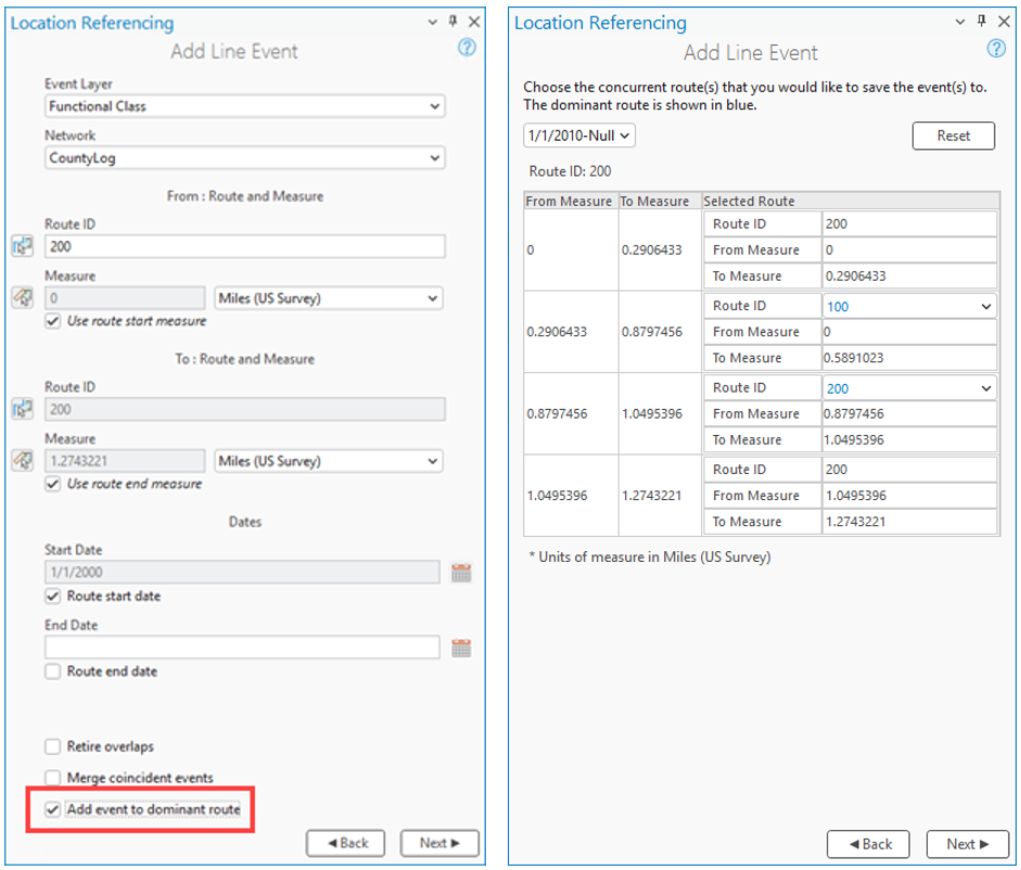
For users with concurrent (overlapping) routes, placement of events onto the primary (dominant) route is important for reporting, calculating certified mileage, HPMS submission, and other operations on LRS data. To ensure events added using ArcGIS Pro are always placed onto the primary route, a new option has been added to the Add Point Event and Add Line Event tools. When enabled, events being added will always be placed onto the primary route if there are concurrencies. This allows users to add events via the way they were collected, but ensure they are placed onto the primary route as they’re added to Roads and Highways/Pipeline Referencing. This option can be enabled/disabled on an edit-by-edit basis or configured as an ArcGIS Pro application setting if business rules are consistent for data editors within the organization.
Advanced attribute table editing for LRS events
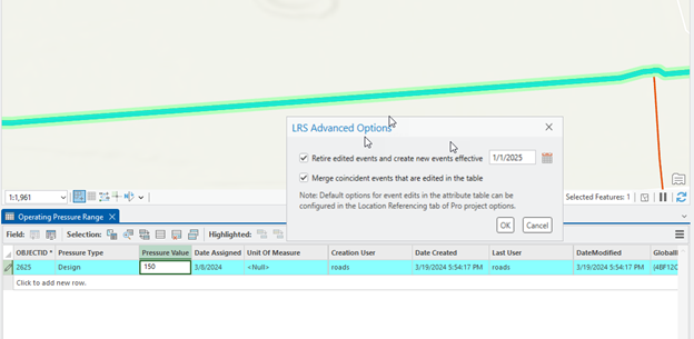
Attribute edits on existing events is commonly completed using the attribute table within ArcGIS Pro. To streamline editing workflows data editors now have the option to configure whether an event will retire, and a new event is created when editing business attributes on LRS event data as well as if that event should merge with any adjacent events that share the same attributes. Using an ArcGIS Pro application setting, editors can configure the default behavior for this capability including whether it’s enabled/disabled, what date should be used for retirement, whether coincident events should merge when possible, and whether the dialog with these options appears after an edit.
ArcGIS Enterprise Capabilities
Widgets for ArcGIS Experience Builder
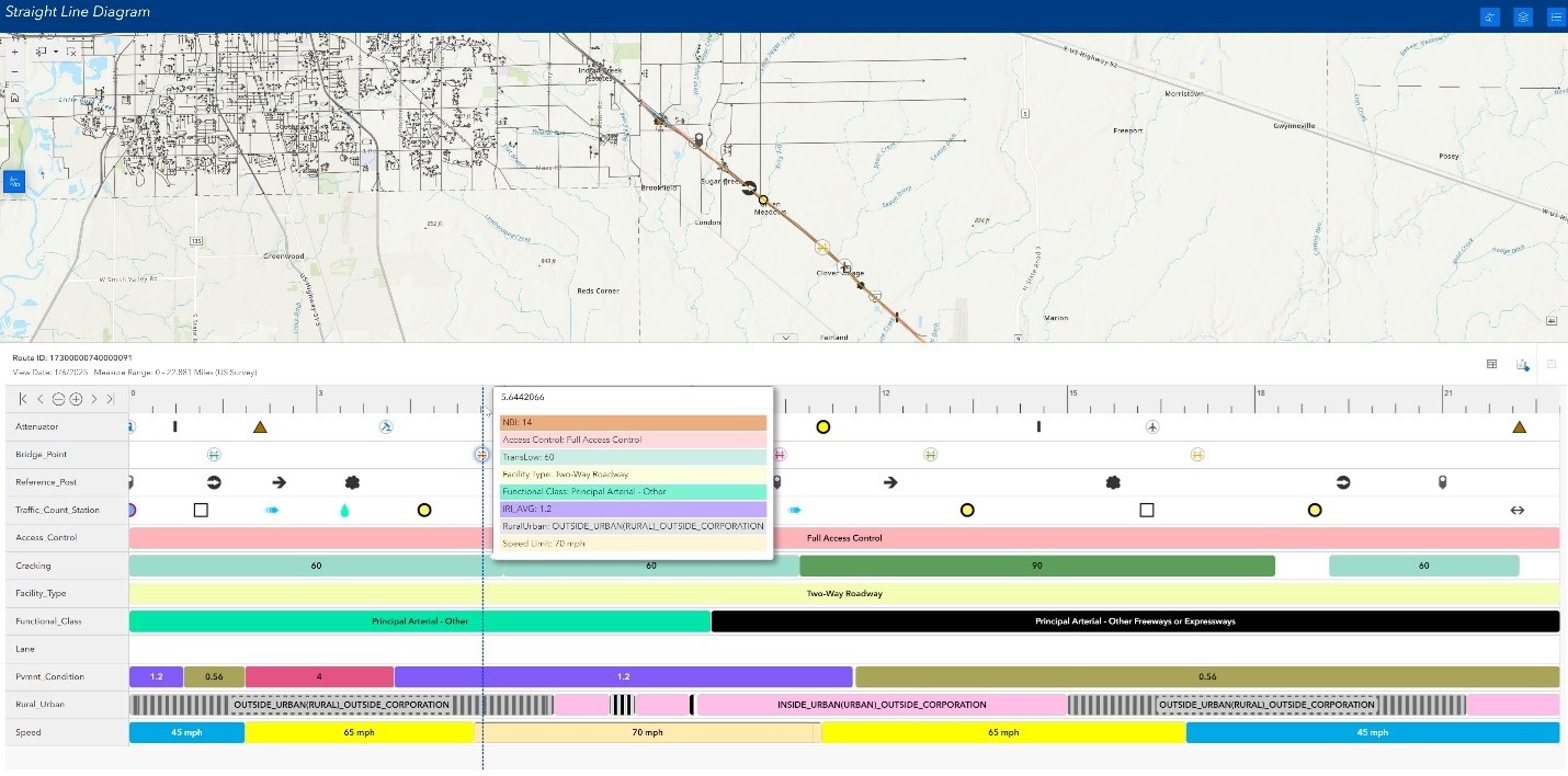
Starting with the 11.3 release of ArcGIS Enterprise, Roads and Highways and Pipeline Referencing users have had the ability to configure an event editing experience using widgets available in ArcGIS Experience Builder. The new Dynamic Segmentation widget joins the growing library of configurable workflows by allowing users to dynamically segment events and either view as a straight-line diagram or as a table.
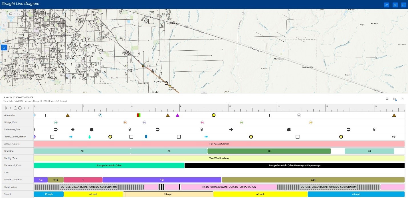
This straight-line diagram view allows users to visualize the relationships between LRS event characteristics along a route in a “stacked” view, making it easier to see where certain characteristics begin/end in relation to one another.
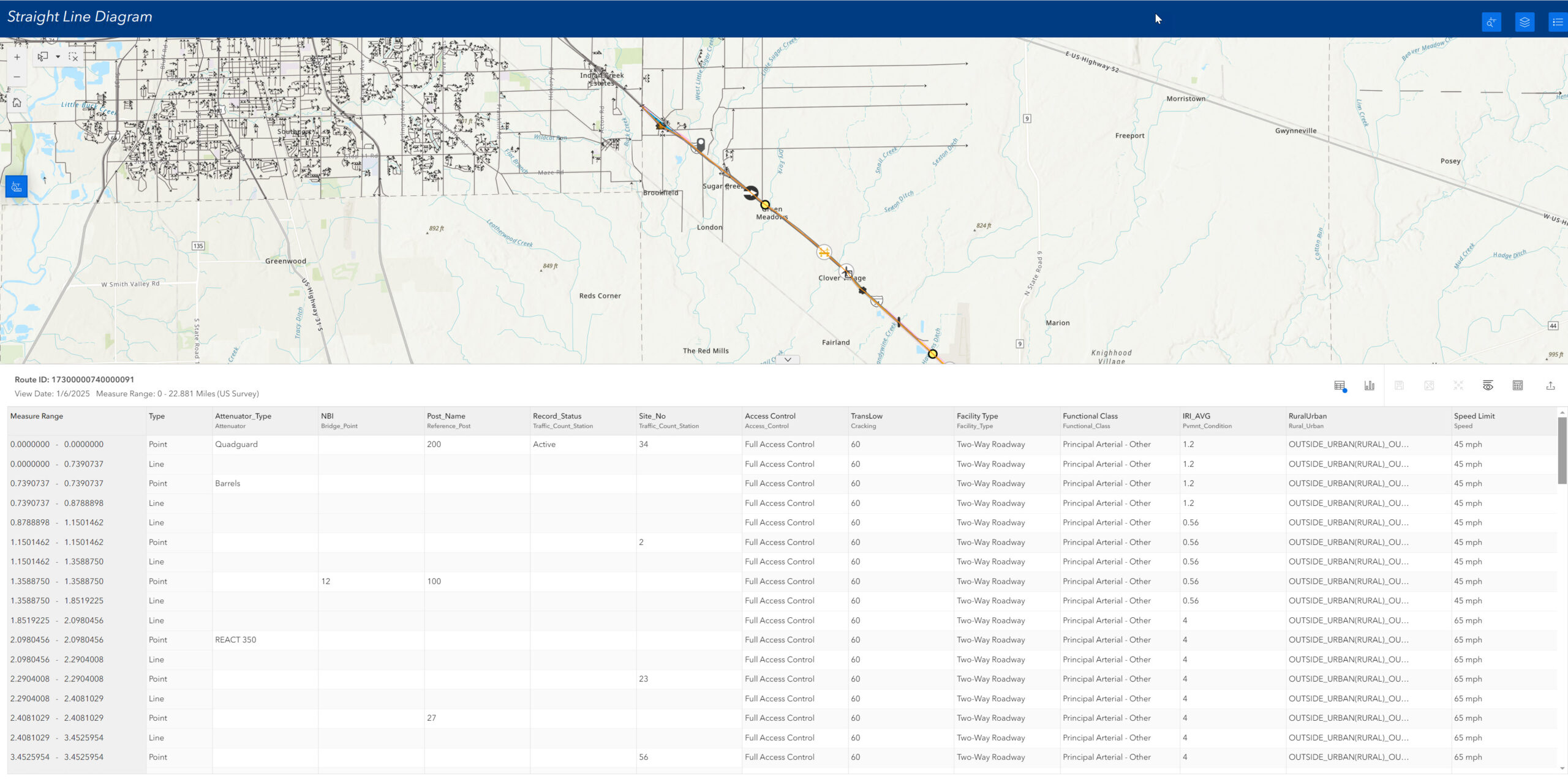
The table view allows users to view the dynamically segmented data as a table and to make updates to an event’s characteristic that might be driven by other related characteristics (such as functional classification and speed limit or pipe diameter and operating pressure).
This release of Enterprise also includes enhancements to the Search by Route widget. Users can now search by lines when they search on a line network and will see derived network information in the results of the tool.
Additionally, contingent values are now supported in the Add Point Event, Add Line Event, Split Event, and Merge Events widgets. These widgets also include several smaller enhancements and bug fixes based on user feedback. ArcGIS Experience Builder templates for deploying LRS applications utilizing all the LRS widgets have been updated to incorporate the new dynamic segmentation widget and to streamline deployment of these applications.
Point Event support in Query Attribute Set REST operation
As mentioned above, all the dynamic segmentation tools within ArcGIS Pipeline Referencing and ArcGIS Roads and Highways now support including LRS point events in the results. This enhancement is also included in the Query Attribute Set REST operation allowing for dynamic segmentation of both point and line event data in a single operation.
Address Data Management Support
For agencies who maintain both addressing and roadway characteristic information in ArcGIS Roads and Highways (and for many in combination with the Address Data Management solution), additional capabilities have been added to support these deployment patterns.
Address range information updates in Dynamic Segmentation
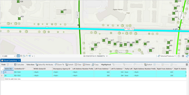
Both the Overlay Events geoprocessing tool and Query Attribute Set REST operation supports including the centerline or event layers that contain address range information in dynamic segmentation operations. At this release, when records from those layers are split during dynamic segmentation, the address information is updated based on the proportion of the split along the centerline/event. The example below illustrates this new capability. The two centerlines representing W Ogden Ave as it approaches N Mill St have the number of lanes change from 4 to 5 lanes. The address block range information on the two centerlines are 308 to 395 and 424 to 535.
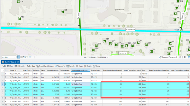
When the centerlines and number of lanes LRS event are included in a dynamic segmentation, there will be segmentation along both centerlines where the number of lanes change. The address ranges for the centerlines are updated in the output of the dynamic segmentation to 309 to 381, 382 to 394, 424 to 433, and 434 to 535.
Integrating Roads and Highways with Address Data Management solution
For users getting started with the combined Roads and Highways and the Address Data Management solution deployment pattern, a new python script is available to create your LRS and the required schema items within the geodatabase that comes with the Address Data Management. Users can run this script on the geodatabase that is available with Address Data Management and the minimum schema items for the LRS will be created within the feature dataset and the LRS will be created with all the correct fields mapped and configured. The script is available at https://github.com/Esri/LRSAddressDataManagement.
Resources
ArcGIS Roads and Highways Product Page
ArcGIS Pipeline Referencing Product Page


Article Discussion: