Every February, Esri hosts a Federal GIS conference in Washington, DC with thousands of our federal government users in attendance. Join us at the 2025 FedGIS conference where we will discuss the latest capabilities of ArcGIS, including ArcGIS Knowledge and Knowledge Studio, a ready-to-use web app for exploring connected data.
ArcGIS Knowledge extends ArcGIS Enterprise to enable data fusion, advanced analytics, investigations, link analysis, and graph analytics powered by spatial knowledge graphs. With knowledge graphs providing a foundation for exploring all the structured and unstructured data for your mission, organizations can now leverage ArcGIS to solve more complex problems that require integrated spatial insight.
Join us for one of our technical sessions or stop by our booth on the Expo floor to talk to one of our product experts. For existing ArcGIS Knowledge users, please consider providing us feedback in our user research study. And as always, we are available to schedule one on one sessions.
Esri’s FedGIS conference is one of the best opportunities for users in the federal government to meet with Esri’s product experts, ask questions, and share their experiences and feedback concerning our products. We are eager to learn how ArcGIS Knowledge and Knowledge Studio are helping your organization connect, analyze, and visualize and investigate large amounts of data. Come share your experiences with ArcGIS Knowledge and let us know how we can help expedite your workflows and improve your decision making process using this innovative product.

Technical Sessions
We are pleased to announce that the following sessions will be available for ArcGIS Knowledge and Knowledge Studio.
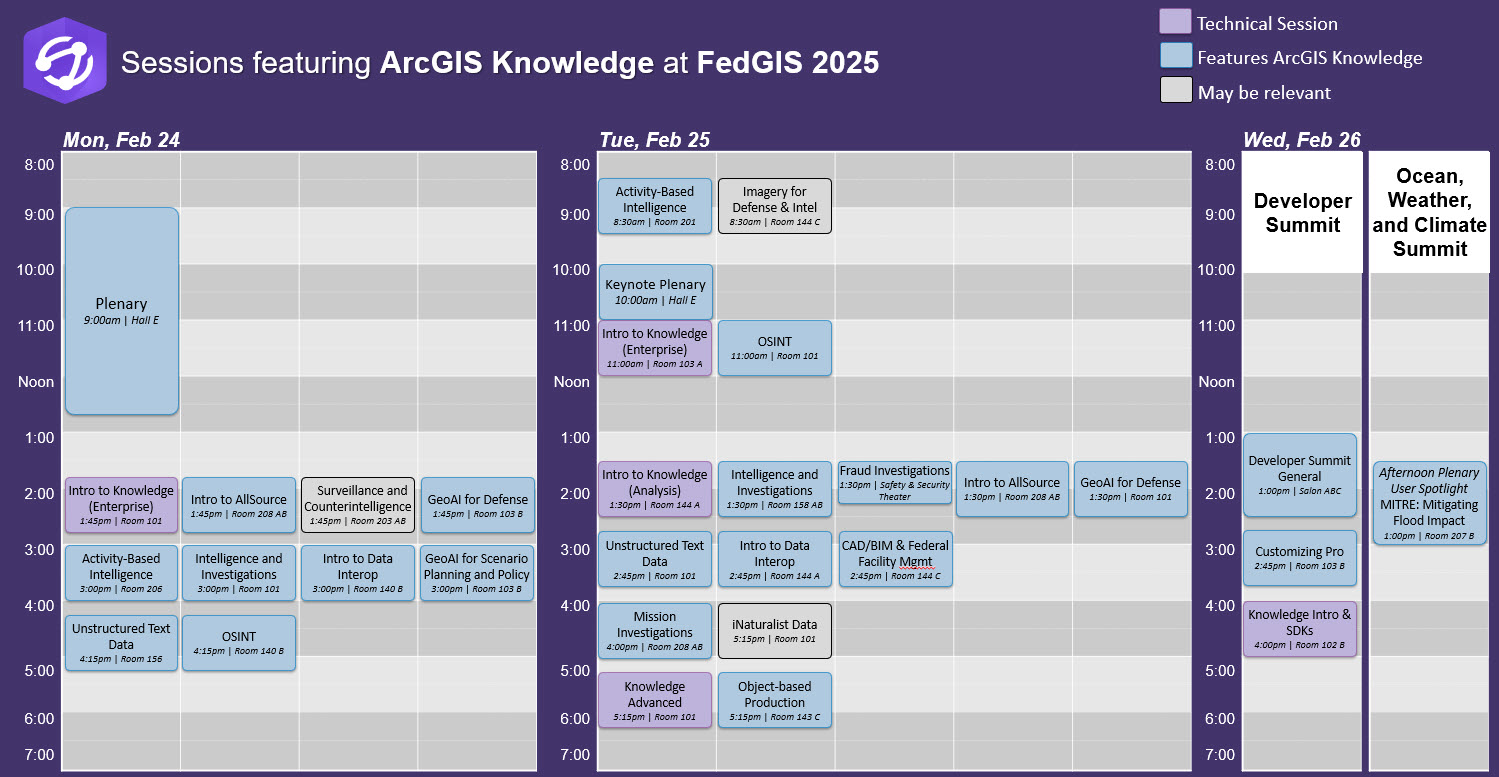
- ArcGIS Knowledge: Fundamentals of Enterprise Knowledge Graphs and Link Analysis (2 sessions, 1 hour)
For anyone new to knowledge graphs in ArcGIS, this session will introduce ArcGIS Knowledge and explain the many ways it extends ArcGIS Enterprise to empower you with connected data and new analysis tools. You’ll also see examples of using Knowledge and link analysis tools in ArcGIS Pro, the new Knowledge Studio web application, and other ways to add graph driven context to your enterprise data and ArcGIS applications. - ArcGIS Knowledge: Fundamentals of Connecting Data and Analyzing Relationships (1 session, 1 hour)
For analysts new to knowledge graphs or link analysis in ArcGIS, this session will introduce ArcGIS Knowledge and explore how you can apply built-in graph analysis tools in your workflows. This is a general session for analysts or investigators in any domain or sector with any level of experience with other link analysis tools or ArcGIS Pro. You will see end to end demonstrations of Knowledge in Pro and Studio (web app). - ArcGIS Knowledge: Beyond the Basics of Graph Data and Link Analysis (1 session, 1 hour)
This is for anyone who is already familiar with the concepts of entities and relationships or who attended the Intro to Knowledge session. You’ll hear directly from Esri’s graph analytics experts about how to use capabilities like Filtered Find Paths, Arcade expressions, openCypher, Python Notebooks, Graph RAG, and more in ArcGIS Knowledge. We will also be joined by Lt Col Brian Hellesto of Air University.
Lt Col Hellesto (F-35/A-10 Pilot) is the lead military instructor in the Joint All Domain Strategist (JADS) Program at Air University, a one-year program for top field grade officers across all branches of service to prepare them for leadership roles in future strategies, plans, and policies as well as key command positions. Lt Col Hellesto will present his innovative use of ArcGIS Knowledge in support of strategic design and military planning. It promises to be an engaging and informative presentation, shedding light on cutting-edge applications of knowledge graphs in ArcGIS in the context of decision support and military and intelligence use cases. - Intro to ArcGIS Knowledge Graphs & Extending with ArcGIS SDKs (1 session, 1 hour) Primarily for developers or anyone who wants to learn about using the ArcGIS Map SDKs for JavaScript (web), .NET (desktop/Pro), and the ArcGIS API for Python. You’ll also learn how to connect different data sources to build and use knowledge graphs and graph databases in ArcGIS.
To add these sessions to your schedule, or see more details of each session, including who, what, when, and where, please refer to these highlighted session from our open FedGIS agenda.
Intelligence and Public Safety
See how ArcGIS Knowledge and Knowledge Studio relate to the Intelligence and Public Safety sectors:
- ArcGIS: Supporting Intelligence and Investigations (2 session, 1 hour)
Especially for investigators and intelligence analysts, this session will explore many different link analysis tools including some ArcGIS Knowledge graph analysis tools. You’ll also see several different temporal analysis tools and visualization capabilities. - ArcGIS: Investigating Fraud and Financial Crime (1 session, 45 minutes)
Take a quick break from the Expo to attend this featured demonstration in the Safety & Security Theater area. You’ll see how knowledge graphs and link analysis can help solve a money laundering a credit card fraud case with a demo of ArcGIS Knowledge using ArcGIS AllSource. - ArcGIS Mission: Maximizing Field Operations and Real-Time Investigations (1 session, 1 hour)
This session plans to include a demo incorporating ArcGIS Knowledge, ArcGIS AllSource, and ArcGIS Mission together in field operations/investigations
Defense & Intelligence
See how ArcGIS Knowledge and Knowledge Studio relate to the Defense and Intelligence sectors:
- ArcGIS: Enabling Activity-Based Intelligence (2 session, 1 hour)
Activity-based intelligence is the “OG” use case for combining spatial analysis and graph analysis capabilities. This session is for anyone who wants to learn how to analyze movement or track data from cell phones, vehicles, and other sources with graph analytics to identify movement patterns and explain why these movements are occurring. - Object-Based Intelligence Using ArcGIS: Object Production, Management, and Dissemination (1 session, 1 hour)
This session is for analysts who rely on documented ontologies for organizing and categorizing information about facilities, weapons, military units, and other Order of Battle information. You’ll see how to integrate an existing ontology into an ArcGIS
Knowledge graph and use the pre-defined schema to connect multiple authoritative data sources. - ArcGIS: Exploring Open-Source Intelligence (2 sessions, 1 hour)
Often when trying to turn open-source information into actionable intelligence, analysts have to deal with multiple disparate types of data, messy schemas, and critical details hidden in images or unstructured text. In this session you’ll see examples of using ArcGIS Knowledge to help organize OSINT data and gain important insights using graph analytics tools. - ArcGIS: Working with Unstructured Text Data (2 sessions, 1 hour)
When trying to build a graph, users often have unstructured data that contains important context and making it usable can be time consuming. In this session, you’ll learn about different strategies for bringing structure to unstructured data using Esri tools like LocateXT and AI. This will also include partners NetOwl and Voyager Search, which can be used for automatically creating entities and relationships inside of ArcGIS Knowledge from unstructured data. - ArcGIS: Modernizing Defense and Intelligence Operations with GeoAI (1 session, 1 hour)
As one example of GeoAI supporting defense and intelligence operations, this session will feature an end to end demonstration of using ArcGIS Knowledge for data fusion and analysis of a crisis in Sudan. It also includes natural language processing, data fusion, and link analysis. - Transforming Federal Assets and Building Projects with Geospatial Context (1 session, 1 hour)
This session will feature a short demonstration of ArcGIS Knowledge with Indoors and 3D scenes to analyze denial of entries. If you are interested in facility security, insider threat, or counterintelligence related to building and infrastructure projects, or curious about working with knowledge graphs in ArcGIS alongside CAD/BIM data and building life cycle tools.
Other Sessions Worth Checking Out
The fun doesn’t stop with the Technical sessions listed above. Join us for the following sessions where we will discuss how ArcGIS Knowledge relates to other ArcGIS products.
- ArcGIS AllSource: An Overview and What’s New (2 sessions, 1 hour)
For Defense and Intelligence analysts and law enforcement investigators, ArcGIS AllSource is a desktop analysis application and client for ArcGIS Knowledge. This presentation will feature Esri data partner Janes Defense and will provide you with some insights into how AllSource can help you now and what is coming in the future. - ArcGIS Data Interoperability: An Overview (2 session, 1 hour)
For anyone looking for no code ways to ETL (Extract, Transform and Load) data into ArcGIS and ArcGIS Knowledge, this session is for you. The Data Interoperability Extension supports hundreds of different file and database formats allowing you to load data at an enterprise scale into a feature service or ArcGIS Knowledge Graph from third party databases. - GeoAI for Scenario Planning and Policy Impact (1 session, 1 hour)
As our understanding of a given species evolves over time, the policies governing human interactions with those species may change too. The U.S. Fish and Wildlife Service (FWS) is using ArcGIS Knowledge and GeoAI to track policy changes through space and time. FWS will discuss the tools they’ve built to link species’ needs to the potential threats or activities that impact them and conservation measures that influence these needs.
ArcGIS Knowledge Focused Agenda

Need a little extra help deciding on which sessions to attend? Here are two customized agendas for ArcGIS Knowledge, perfect for helping you be in the right place at the right time.
Click through, log in, and add sessions directly to your agenda.
All ArcGIS Knowledge Sessions:
https://event.esri.com/widget/esri/25fedgis/1734097986642001HnAS
ArcGIS Knowledge Highlights:
https://event.esri.com/widget/esri/25fedgis/1737125353000001V68H

Developer Summit
- General Session (1 session, 90 minutes)
A terrific introduction to the ArcGIS development experience, including a demo about leveraging ArcGIS Knowledge within custom AI Skills using the Maps SDK for .NET. - Intro to ArcGIS Knowledge Graphs & Extending with ArcGIS SDKs (1 session, 1 hour)
For Developers and beginner coders. This session will walk you through the basics of ArcGIS Knowledge and then move into automating operations with Knowledge using the ArcGIS Map Software Development Kit for Javascript, .Net (Desktop), and Python. - Customizing Your ArcGIS Pro Experience (1 session, 1 hour)
For people wanting to streamline their ArcGIS Pro experience this session will teach you how to tailor the user interface of ArcGIS Pro and customize it around your individual workflow. This is especially useful for ArcGIS Knowledge users who use ArcGIS Pro as their client.

Ocean Weather and Climate Summit
- Afternoon Plenary User Spotlight (1 session, 2 hours)
Dr. Alex Philp and Ms. Kristy Weber of MITRE will present their innovative use of ArcGIS to predict and understand the potential impacts of extreme weather events and climate change with emphasis on critical infrastructure and downstream effects. ArcGIS Knowledge enables MITRE to analyze the connections and dependencies among infrastructure assets. This session is for anyone interested in emergency response, critical infrastructure, transportation, community resilience, and supply chain/logistics operations.

Visit us at the Expo
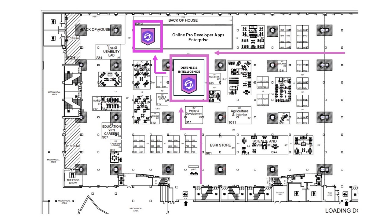
Product Managers and other team members will be available at our booth in the ArcGIS Products area during Expo hours:
- Mon, Feb 24 | 9:00 a.m. – 6:00 p.m. PDT
- Tues, Feb 25 | 9:00 a.m. – 6:00 p.m. PDT
- Wed, Feb 26 | 9:00 a.m. – 6:00 p.m. PDT
Don’t forget, we will also have Solution Engineer specialists at the Public Safety, Defense and Intelligence, and Natural Resources industry booths with industry specific demos.
See you there!


Help Improve the ArcGIS Knowledge Experience
If you are already an ArcGIS Knowledge user, please help us test new designs for the knowledge graph data loading experience by participating in the User Research Lab to get a sneak peek of our latest designs and ideas and share your valuable feedback. Plus, receive some complimentary swag as thanks!
Be Part of Esri’s User-Centered Innovation
Simply fill out a short questionnaire to sign up and be matched with the Knowledge session. No preparation is needed—just show up, have fun, and make a direct impact on Esri’s future services.
Sign Up to Participate in User Study
Why ArcGIS Knowledge
Organizations work better when analysts and managers have immediate access to all their data in context. They can achieve this by bringing information about the people, places, sensors and concepts that matter together into a spatial knowledge graph, using spatial and logical relationships in a data model that is intuitive and in language of their business or mission.
By leveraging the combined power of spatial and graph analytics in spatial knowledge graphs, analysts can find hidden and important patterns in their data quickly. Using ArcGIS desktop applications, ArcGIS Knowledge Studio in the web and Knowledge APIs (REST, Python, JavaScript, .NET) your analysts, data scientists and data engineers can surface that key data quickly in full context to stakeholders and decision makers.


Article Discussion: