Hello, Users and GIS Enthusiasts,
As the year wraps up, it’s time to end strong with some exciting treats. The latest release of ArcGIS Earth is here, packed with new features to enhance your productivity in the new year.
Our latest release improves user workflows with the integration of ArcGIS Survey123, real-time GPS, enhanced location search, and mobile 3D model support, among others. Whether you’re in the field or at your desk, these features ensure your data is accurate and consistent, improve spatial understanding, and enhance communication and collaboration with your team and external stakeholders.
So, pour yourself a holiday beverage, kick back, and learn how ArcGIS Earth can make your GIS life a whole lot merrier!
ArcGIS Earth for Desktop
ArcGIS Survey123 Integration
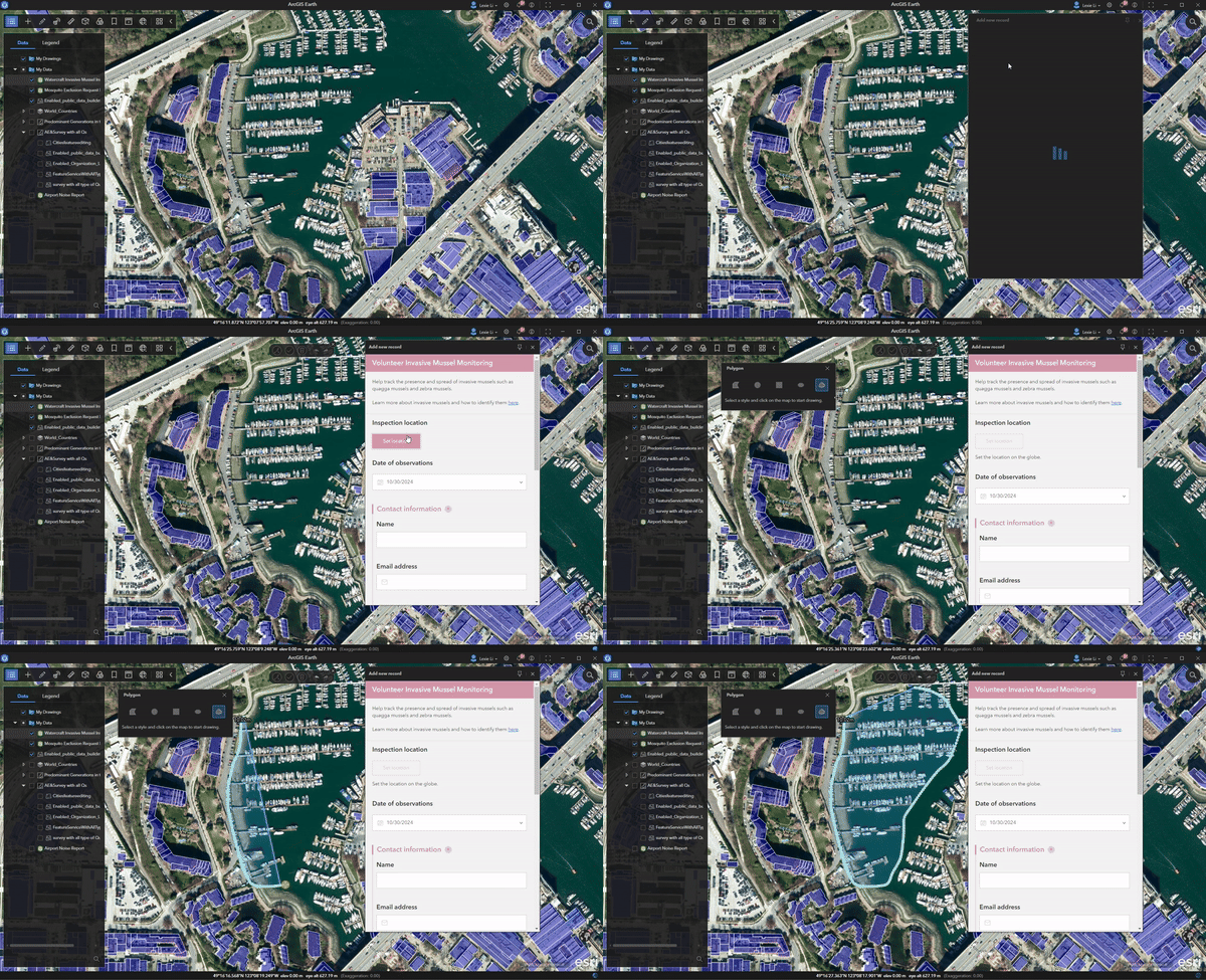
ArcGIS Earth now integrates ArcGIS Survey123 workflows, delivering a seamless, efficient solution for submitting and receiving survey records directly in the app. By integrating ArcGIS Survey123 workflows, users can effortlessly manage and report operational data in the required formats, paving the way for enhanced collaboration and engagement.
This integration transforms multitasking efficiency, letting you reference multiple documents, datasets, or communication tools on a larger screen while filling out forms. It is also easier to achieve higher precision when drawing or editing geometries, especially for complex shapes necessary for detailed mapping.
There are many advantages of using Survey123 in ArcGIS Earth. Picture yourself in a disaster management and response scenario; desktop environments enable intricate spatial data entry, crucial for crafting detailed disaster impact assessments and response plans. Environmental analysts can access recent satellite or aerial imagery to spot illegal logging or road construction, vital for timely detection of unauthorized activities. This imagery analysis helps identify specific points of interest, marking them for further investigation.
Visualize analysts filling out detailed survey forms for each identified site, drawing precise spatial geometries like polygons to outline deforested areas or lines to indicate illegal roads. The combination of recent imagery, spatial data, and survey information empowers comprehensive reporting, steering enforcement actions and bolstering conservation efforts.
Connect External GPS Sensor
Users in the field can now connect to external GPS sensors and view real-time positioning information directly in ArcGIS Earth. By connecting to National Marine Electronics Association (NMEA) Global Positioning System (GPS) feeds, users can maintain situational awareness with precise location tracking. Additionally, this feature allows for the export of GPS tracks and captured observations, enabling further analysis and integration into other workflows.

Reverse Geocode and Offline Locators
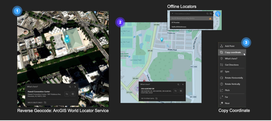
The new reverse geocoding feature simplifies finding essential location information directly within ArcGIS Earth. Simply right-click and select “What’s here?” for immediate address, coordinate, or custom locator details. This eliminates the need to use external apps to retrieve real time location information. Additionally, the app supports offline locators contained within mobile map and scene packages, enabling reverse geocoding and geosearch, also known as location search, capabilities when disconnected.
Download Map Tiles for Offline Use
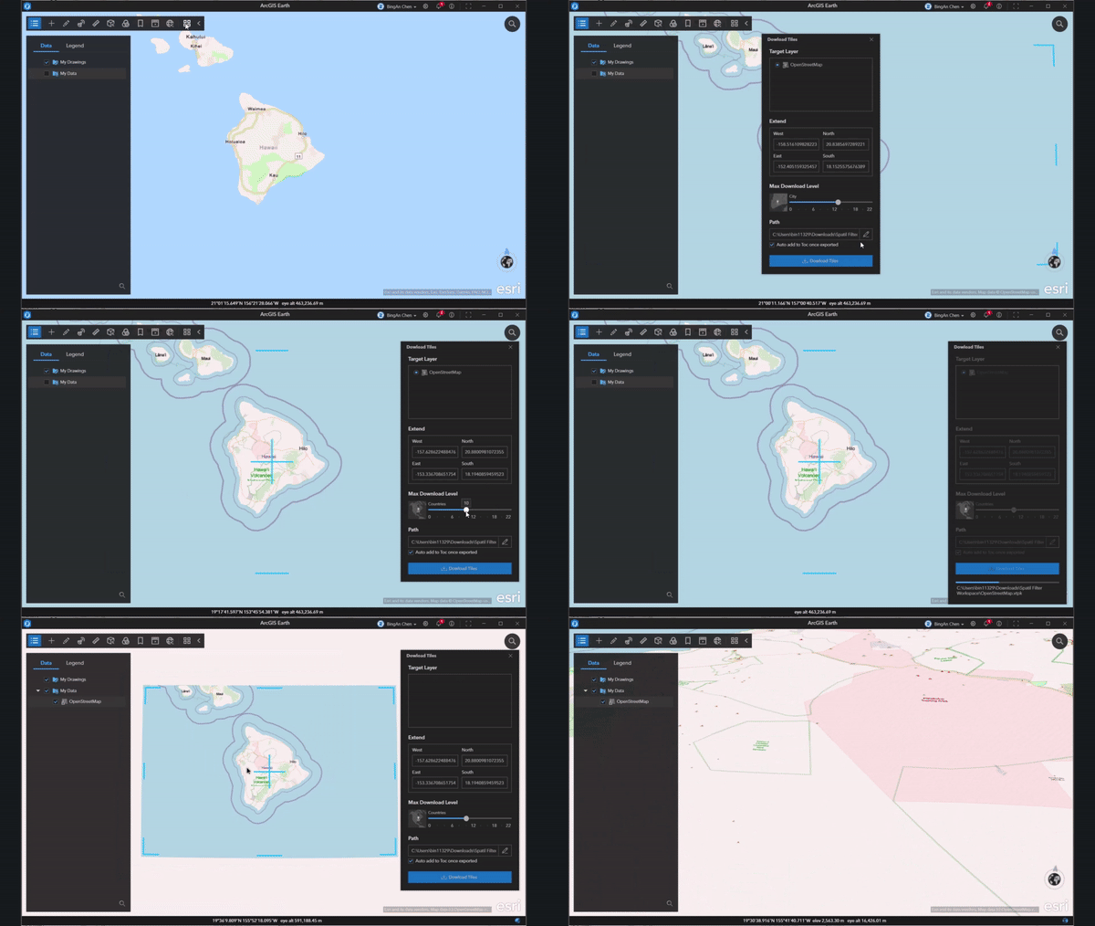
Download vector and raster tiles, including those from ArcGIS Online or ArcGIS Enterprise, and use them offline. This feature streamlines data access and staging for offline use cases, ensuring that necessary map data is always readily available. Imagine having a self-service map data kiosk at your fingertips, where you can swiftly download and utilize the most up-to-date geographical information regardless of your connectivity. This capability significantly enhances productivity and collaboration in remote or low-connectivity environments. Whether you’re working in the field, conducting environmental research, or managing disaster response, having offline access to detailed map data empowers you to make informed decisions and maintain situational awareness. This feature not only improves operational efficiency but also fosters a sense of independence and readiness, knowing that you have all the essential tools and information at your disposal whenever and wherever you need them.
Apply Spatial Filters to 3D Data
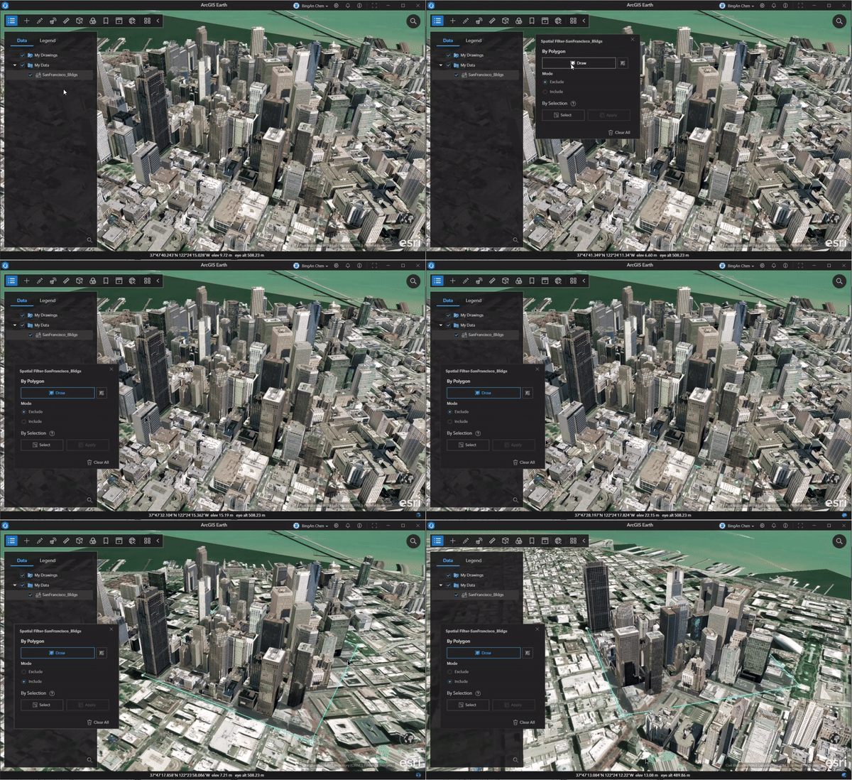
Define areas of interest using polygons or individual object selections and apply visual filters against 3D object and point scene layers. This visual filtering process allows for excluding outdated data and replacing it with new data, enhancing the clarity and relevance of the displayed information. Multiple spatial filters can be applied to a scene, enabling a focused view on the most pertinent data and improving overall spatial understanding.
3DConnexion SpaceMouse Enterprise Support
Explore the globe like never before with ArcGIS Earth’s support for 3DConnexion’s SpaceMouse. Leveraging the SpaceMouse’s 6-Degrees-of-Freedom (6DoF) sensor, users can enjoy unparalleled smoothness and intuitiveness in 3D navigation. This enhancement ensures that viewing and interacting with the globe, above or below the surface, becomes a seamless and immersive experience, transforming how geospatial data is explored and analyzed.
KML Enhancements
- Time Enabled KML Playback Enhancements – The new Real-Time KML Drawing enhancement reduces clutter by updating only the latest observation from dynamic entities streamed via a KML network link, ensuring a clear display. Previously, continuous rendering led to a cluttered and unusable workspace. This improvement makes the software a reliable option for maintaining situational awareness in operations with real-time positioning data.
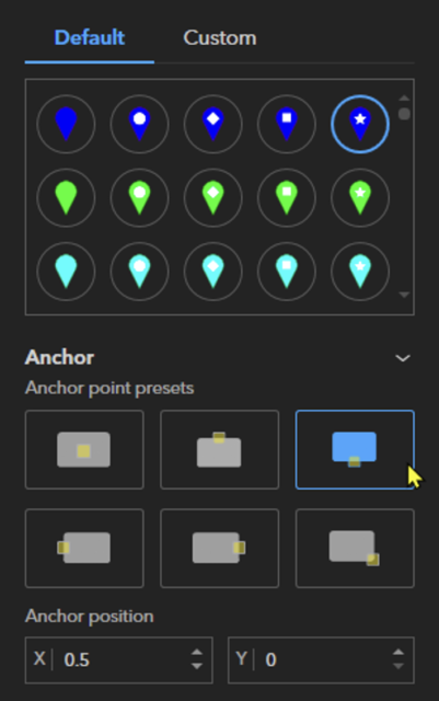
- KML Placemark Anchor Point Positioning – Users can now define the anchor point for KML placemark symbology
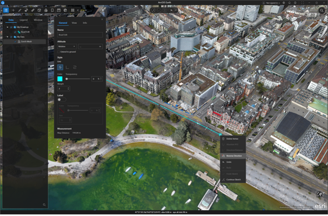
- Reverse KML Line Direction – Great news, when editing a KML line, you no longer have to add or manipulate vertices manually. With this release, you can now reverse the direction of a line to continue editing from the original starting point.
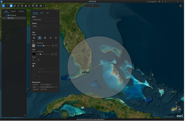
Circle Radius – Circle polygons now include a radius measurement in the layers properties. Please note that the radius measurement will reset if the geometry of the circle is edited. This feature provides a quick way to know the radius of a circle within your scene, which is useful in situation such as determining the range of a cell phone tower.
- Dynamically Size KML pop-ups – KML pop-up windows dynamically resize to fit the content window which eliminating the need for users to adjust the pop-up.
User Interface and User Experience Enhancements
- Performance improvements – In our latest release, we focused on enhancing how features are drawn and rendered in ArcGIS Earth. Previously, we implemented a fix aimed to force all data to draw, but it led to performance issues when handling high-density 2D data, specifically feature services and web maps. The great news is that we have significantly improved performance in this area. Now, by default, points use dynamic mode for rendering, while lines and polygons use static mode. These settings boost performance across the board, but you can also right-click and choose the desired rendering mode for individual features if needed. This improvement is just the beginning, as our team is continuously working to enhance performance further. Stay tuned for more updates.
- Interactive analysis instruction and animation control – The interactive analysis tool was redesigned to improve usability. By unifying the From Camera and From Point modes, users now receive intuitive text and image guidance, making these tools more accessible and efficient. In addition, the Animation mode now offers precise playback using real-world speed versus relative speed. Animation playback was improved, featuring smoother movement during turns, 3D model lock-on capability, and precise frame-by-frame navigation.
- 360-Degree Heading Format – The 0 to 360-degree heading format in ArcGIS Earth simplifies navigation and orientation-based workflows. Eliminating the need to mentally convert negative degrees, this enhancement improves user experience and provides a more intuitive representation of headings. It also ensures better integration with existing tools and workflows. These improvements allow users to focus on their tasks without the distraction of unnecessary calculations, resulting in a more streamlined and user-friendly experience.
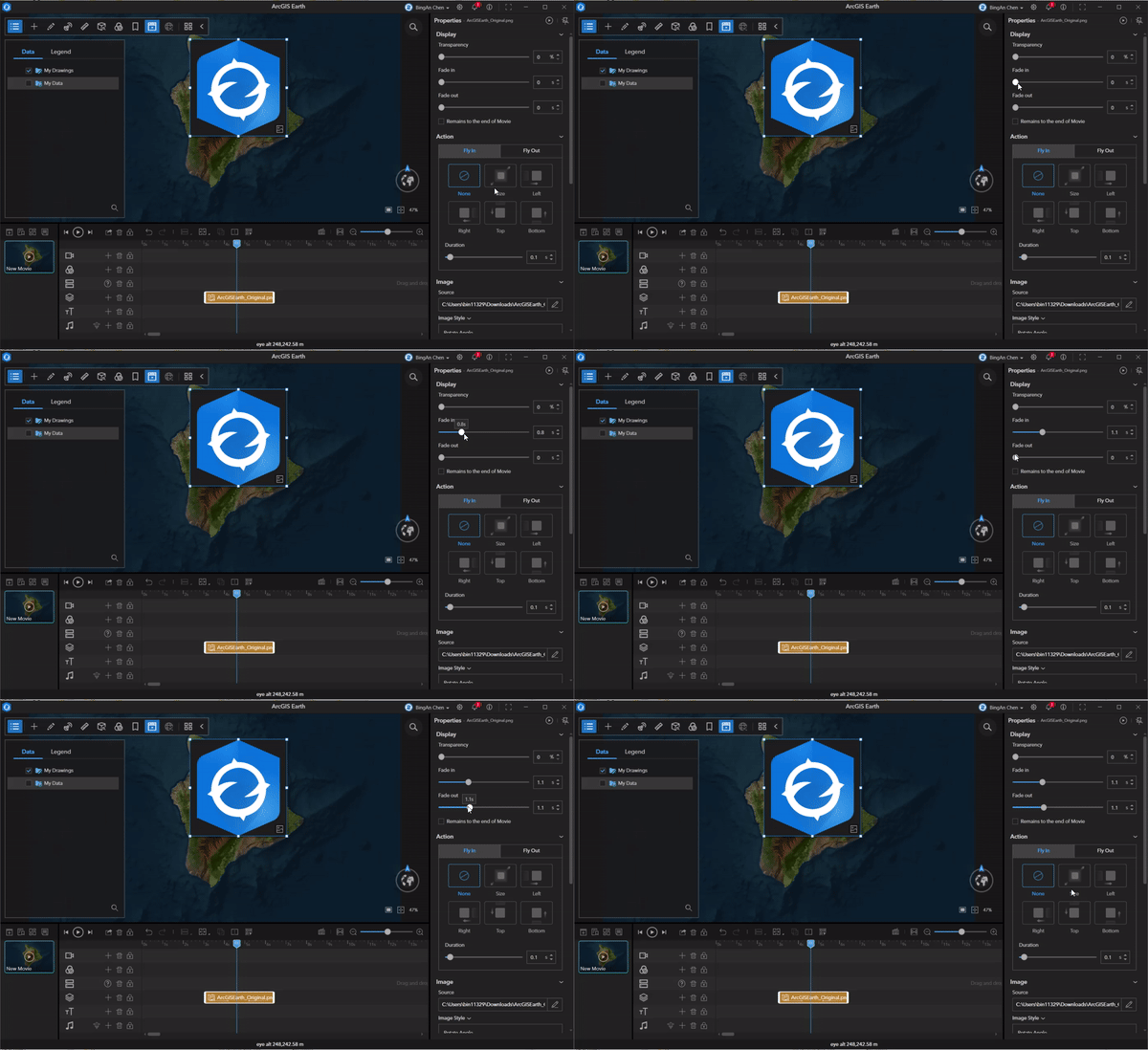
- Media marker animations added to ArcGIS Earth movie – ArcGIS Earth’s movie capability received some new enhancements. You can now add a title and description to image, GIF, and video markers, making it easier to provide context to media within your movie projects. Additionally, the redesigned Fly in and Fly out animations offer a smoother, more dynamic way to enhance your movie scenes. These enhancements will bring a fresh and professional touch to your next movie project.
Visit our What’s New for ArcGIS Earth desktop resource page to see a full list of new features and enhancements.
ArcGIS Earth for Mobile
3D Model Support
Digital Asset Exchange (DAE) 3D models can now be effortlessly added, positioned, adjusted, and managed within the mobile app. This feature seamlessly integrates DAE 3D models (including DAE models that are embedded in a KML or KMZ) into mobile workflows, allowing users to tailor their scenes and operate more efficiently without the need for additional applications for minor modifications.

Manage Visibility of Web Service Sub-layers
In our last release we added the ability to managing and navigating detailed KML data on ArcGIS Earth mobile. This capability has been expanded to support all web-layers to make it easier for users to see the web-layer’s entire hierarchical structure. As a result, all embedded layers and layer types are visible, and users can adjust their visibility to tailor how data is displayed to meet their specific needs and goals.
Tour Data Management
It’s now easier to share insights stakeholders using the redesigned ArcGIS Earth mobile tour capability. You can now share tours as KMZ files and publish them directly to the ArcGIS Portal for easy dissemination and discovery.
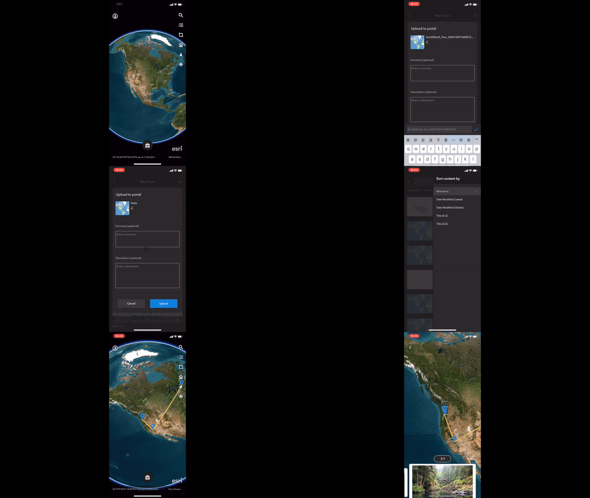
Visit our What’s New for ArcGIS mobile resource page to see for more details.
Closing Comments
We hope you find the new features and enhancements in this release of ArcGIS Earth useful and enjoyable. Your user feedback is crucial for our ongoing development and progress, so please continue to share your thoughts with us.
Also, we couldn’t end this year without a heartfelt thank you to the ArcGIS Earth and ArcGIS Maps SDK for Native Apps engineering teams for delivering what is the biggest release for ArcGIS Earth since its inception. This was a huge endeavor and we appreciate all the hard work.
Thanks again for everyone’s support and we look forward to sharing more innovations in the new year. Happy geospatial exploring!


Article Discussion: