ArcGIS StoryMaps has just been updated with a fresh batch of homemade features and enhancements.
- Add audio to your stories
- Compare maps using the new swipe block
- Drag and drop immersives
- Oodles of mapping enhancements
- Sidecar panel size options
- Helpful embed tools
- Click to expand images
- Collections navigation updates, preview, and other enhancements
- And lots more…
Special announcement
Before getting into the details of all the new features and enhancements, we wanted to let you know our team has been working to make the latest generation of storytelling tools available to ArcGIS Enterprise customers.
We’re pleased to announce ArcGIS StoryMaps is scheduled to arrive in the upcoming ArcGIS Enterprise 10.8.1 release. This first enterprise release will contain functionality equivalent to the April 2020 update of the Online version of ArcGIS StoryMaps.
Now back to our regularly scheduled update…
Audio (beta)
Add a new dimension to your stories with sound. You can now use audio in your stories in two ways.
If you have an audio clip that you want readers to stop and listen to, you can add an inline audio clip within your story narrative. This can be done in the main part of the story or in a sidecar narrative panel. This option works well for narrated audio or short clips that you want the reader to listen to from beginning to end. Readers can play and pause the audio using the audio player controls.
If you have ambient audio you want to use to set the mood for your readers, you’ll want to take advantage of background audio in sidecar. You can add audio to a specific sidecar slide and it will autoplay in the background without any specific interaction from your readers. When a slide with background audio is shown, the audio will play, and when the reader leaves that slide the audio will stop.
An unmute button will be shown on the first slide with background audio. Once the reader clicks this button, background audio will be unmuted everywhere in the story.
Inline and background audio both support uploaded MP3 files (support for WAV files is coming soon). For inline audio, you can also embed third-party audio hosting services, such as SoundCloud. (The option to embed audio inline was previously available via the Embed option, but is now also available if you select Audio from the block palette.)
For your listening pleasure, here’s a stunning story that uses both background and inline audio: Sounds of the Wild West.
As indicated above, audio features are in beta, so please let us know about your experience. There are some known issues with playing audio in the Safari browser that will be addressed in an upcoming release.
Swipe (beta)
This release brings another classic template into the ArcGIS StoryMaps builder: swipe! The swipe block is easy to use and has several options such as the ability to disable navigation or show the map legends.
Here’s are two gorgeous stories that puts the new swipe block to good use: Grace and Delight and Coastal Flooding (see the “What are the data telling us?” section).
This first version of swipe is currently in beta. We have a lot more planned for it, so stay tuned for future updates.
Drag and drop immersives
You can now easily relocate entire immersive sections within your story by dragging them. Just grab the handle (make sure the slides panel is expanded so you can see it) and pull. Give it a try!
Mapping
Disable navigation
If you do not want your readers to pan or zoom in a map, you now have the option to disable navigation on any express map, web map, or web scene. This is useful if you want readers to be able to click on pop-ups or if the map contains data that may be updated, but you want to keep their attention focused on a particular area.
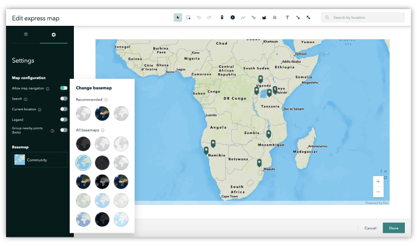
More basemap options for express maps and guided tours
Many of you have asked for more choice in basemap selection for express maps. In this update, you can now select from more than a dozen gorgeous vector basemaps for your express maps. These additional choices are also available in the map settings for guided tours.
Express map point grouping (beta) and annotation enhancements
Your express maps already look great when your readers first see them. Now they look better than ever when your readers interact with them. New point grouping and annotation collision detection algorithms have been applied so that the information in your express maps looks great at all scales and on all screen sizes.
The annotation behavior is always enabled for your express maps. Point grouping is a beta feature that you can enable in the map settings.
Sidecar panel size options
Sidecar’s docked layout now has new panel size options. You can toggle between the three sizes to pick the one that fits your story best. Here’s a story that uses the largest size (50% width): André versus Capability.
Helpful embed tools
Embed properties have received a visual update to make it easier to use and to preview what your embed will look like for readers on smaller screens. Another handy new option is the ability to see and copy the link or code for an embed.

Click to expand images
Readers can now click an image to expand it and view it in a full-page layout. This can be helpful for enlarging images of tables or charts, but it is also nice when a reader wants to examine the detail of a beautiful photo.
Collections
Navigation updates
During its beta period, our amazing design team has been iterating and improving on the navigation experience for collections. They’ve arrived at some good patterns, and collections are now out of beta. The navigation controls for collections now live along the top of the screen, and the transition animation when opening and closing the overview drawer has been enhanced. Stay tuned for updates that will add new (yet possibly familiar…) navigation styles.
Multi-device preview
The multi-device preview experience—which was previously available for stories—has been improved and is now available to help visualize how your published collections will look on different devices.

Add more things to your collections
In addition to stories and many types of ArcGIS apps, you can now add images and PDFs to your collections. Just upload files to your ArcGIS content, share them (at least with your organization), and they will appear in the Add to collection picker (which has received a visual update to make it easier to see which items you’ve already selected).
You can also easily add stories and apps from the Living Atlas to a collection by browsing them by category.

And lots more!
Some other new capabilities worth mentioning…
- Caption text can be formatted with color
- Images or videos from the web can be added to immersive media panels
- Add a guided tour place to the map directly from a search result
- Autoplay now jumps to the top of the story after it reaches the end (rather than scrolling back up); clicking the title of the story in the header also immediately jumps to the top.
- A notification will appear when ArcGIS StoryMaps has been updated
Cover Photo by Alexey Ruban on Unsplash

Maybe a dumb question: Why are new features not offered to Enterpise users right away?
Hi Brian — That’s a good question! The short answer is the release schedules for Online and Enterprise are different. Online releases about four times a year, whereas Enterprise releases about twice. This is partially due to the additional effort required to package and certify all the software and tech that runs in ArcGIS Online (including many ArcGIS apps such as StoryMaps, Web AppBuilder, Survey123, etc.) so that it can be installed and maintained by anyone on their own infrastructure. For that reason, features are typically available in Enterprise a few months after they are made available in Online. You… Read more »
Great enhancements! Almost all stuff I’ve found myself wishing for at one point or another. I did notice one issue with the new audio options, though. (In Google Chrome) I had to click twice to unmute the background audio in every section of the “Sounds of the West” story map. The first click was always unresponsive. Awesome feature, though!
Aaron — Thanks for reporting this. That’s a known issue that we’re looking to address soon.
I’m looking forward to the exploring the new updates! Thank you to the team for making these possible. I have a quick question regarding the collections. How can I change the navigation back to the side of the screen rather than having it on the top?
Hello — For now, the navigation has moved to the top bar, but we are considering bringing back a side placement option in the future.
Hi Owen – really nice enhancements. Quick question – does the new swipe functionality work with Scenes?
Hi John — Not currently, but we are considering that. Can you please share an example use case so we can understand how you’d use it?
Yes, I am involved with a variety of applications showing change over time in 3D scenes. They can be related to natural change or anthropogenic change. Examples include historic land-use change (https://chesbay.maps.arcgis.com/apps/Compare/index.html?appid=abd0664ee0884243895a3b4f4e2c0246), landscape planning/restoration (https://chesbay.maps.arcgis.com/apps/Compare/index.html?appid=ee3478abea4d48609b0f8ba00c0ede54), or sea-level rise (https://chesbay.maps.arcgis.com/apps/Compare/index.html?appid=d4b3d9d260e6471db392bcfb662d0eb7). I was hoping the swipe functionality might be a future option to show scenes explaining change over time.
Any plans yet to have a “tab” set up similar to the Map Series tabbed version? We’re stuck using the old ones until a similar feature shows up.
Hi Alyssa — You bet! We’ve been thinking about replacements for the tabbed and bulleted layouts of the classic Series template for a while. We know these are very popular templates, but wanted to take our time on them before rushing something out. Look for these to arrive this summer.
How can i share my storymap with other groupmembers so that they can edit the storymap?
Karsten — Check out the documentation on co-authoring stories here: https://doc.arcgis.com/en/arcgis-storymaps/author-and-share/co-author-a-story.htm
I’m looking forward to using the new swipe functionality. Does it allow you to use the same map on both sides, but have 1 layer turned off in the left map so that when they swipe from right to left, the layer swipes on? Its a feature in the old swipe app I’ve made use of to avoid needing 2 maps.
The new swipe block is in beta, so there are some features it does not yet support. Currently you can create a swipe with two maps, but we are looking at adding other options, such as the layer swipe you mentioned, in future releases.
Thank you for the new features. I have some trouble with displaying historical maps in storymaps. Here is the example of the layer with the historical map from 1925 (https://lviv-center.maps.arcgis.com/home/webmap/viewer.html?webmap=b5059935e9c34c91a38a0461f0934518). It is visible if the map is open through the Map Viewer. Once I try to add it to a storymap via map or swipe feature, all layers but a historical map appear: https://storymaps.arcgis.com/stories/7a1cd176464f4edd9e5dc81a0cc87786 This layer is not hidden. Nonetheless, it is not visible in the storymap. I tried this with various maps. The problem remains the same. Would you have any ideas about what was done wrong? I would… Read more »
Hello Liubomyr — I’m sorry you are having an issue displaying one of your layers. Would you mind posting your question to our GeoNet community? That is the best place for us to help with specific questions like this. https://community.esri.com/community/arcgis-storymaps
Liubomyr — I added your question to GeoNet here: https://community.esri.com/message/933892-raster-layer-not-appearing-in-story
Great new features !
Others basemap options for express maps and guided tours are planned, especially using custom basemaps from our organization (like Classic Map Tour Template) ?
If yes, do you have an approximate date ?
Thanks
Hugo — Yes, we’re working on that now, and it is planned to be made available in the next few months.
@oevans-2, thanks for your reply