The top priority for every airport is to be safe and secure. Smart airports, equipped with cutting-edge Geographic Information Systems (GIS), are revolutionizing airport safety and security. By integrating real-time data, automation, and location-based intelligence, GIS enhances operational efficiency, situational awareness, and decision-making in emergency response, passenger management, and facility maintenance. As airports become more complex and passenger traffic increases, these advanced GIS tools are essential in maintaining a safe, secure, and seamless environment for both staff and travelers.
Airport Police, Airport Rescue and Fire Fighting (ARFF), and Airport Integrated Operations Centers (AIOCs) utilize GIS as a core component for command-and-control. These departments leverage GIS to streamline mission management and enhance decision-making during daily operations, tactical missions, and in response to both forecasted and unexpected events such as adverse weather or aircraft mishaps. GIS tools fuse air and landside data with real-time security and surveillance systems, such as CCTVs, live traffic and weather feeds, as well as up-to-date and the historical locations of first responders and field workers.
Enhancing Airport Safety and Security with GIS Technology
Leveraging GIS technology, airport security systems can map and monitor threat locations more effectively. At Transportation Security Admission (TSA) and passenger screening areas and other secure ingress/egress locations, GIS collects and stores tabular data, imagery and video feeds about activity. Secure, web-based ArcGIS Dashboards consume and display real-time and historical information on a single screen, improving situational awareness. Field and mobile workers and first responders on the Air and Landsides are using mobile devices to quickly collect accurate, location-based information via configurable mobile apps including ArcGIS Survey123, ArcGIS Field Maps, and ArcGIS Quick Capture. These connect directly with dashboards and greatly improve security and readiness.
Improving Airport Operations, and Safety and Security Indoors
Having location intelligence is essential for safety and security operations. ArcGIS supports safety and security use cases inside the airport building through indoor GIS, which is a unified system to visualize, analyze, and manage facilities. At its core is ArcGIS Indoors which enables the creation of floor-aware indoor maps for asset and space management, safety and security, and wayfinding. ArcGIS IPS can be added to these maps to enable real-time indoor positioning use cases such as asset inspection, live location sharing, and real-time wayfinding, via the blue dot experience. These products’ capabilities are integrated into other Esri products, enhancing them with GIS in indoor spaces.
Indoor maps of facilities show the locations of spaces, assets, and people, as well as marked exits or evacuation routes. This empowers first responders, facilities, and administrators with improved situational awareness through the right information at the right time and enables timely safety and evacuation planning. In addition, critical infrastructure such as smoke detectors, fire alarms, sprinkler systems, fire extinguishers, etc. and their locations are visualized on the indoor map to monitor required maintenance due dates. Mobile workers can then navigate to fire assets, quickly use or inspect them, identify issues, and report discrepancies. Moreover, workers can share their real-me location so first responders can find them faster in case of an emergency.
Watch this video to see how the combined power of ArcGIS Indoors, ArcGIS IPS, and ArcGIS Field Maps streamlines indoor asset management for mobile workers:
Situational Awareness for Improved Emergency Response
Due to the size of airport venues and their nature as high traffic environments, airports are challenged with efficiently coordinating rapid emergency response.
ArcGIS Mission allows personnel to plan, execute, and review both tactical daily and emergency operations. It utilizes critical incident mapping tools to define areas of interest (AOI) and map critical infrastructure, field personnel and resource assignments. It enables Operations Managers and Incident Commanders to coordinate team movements with real-time situational awareness. The peer-to-peer communications feature in Mission ensures that field personnel, first responders, and command staff can maintain persistent communication, sharing location details, chat history, tasks, and reports.
All Part 139 airports are required to conduct emergency response exercises. The Mission tools support planning, executing responses, and conducting after-action reviews and hotwashes. The logging and reporting capabilities are essential during audits, helping to uncover patterns and improve future operations with securely stored key mission data in an organization’s Enterprise portal.
Streamlining Passenger Screening with GIS
Transportation Security Admission (TSA) and passenger screening areas are common bottlenecks prone to delays, impacting on-time departures. Airports are now leveraging GIS to monitor screening queues by collecting anonymous data from travelers’ mobile devices. Using airport Wi-Fi, the location of individual devices is detected automatically without requiring travelers to connect. Using these anonymous data points, GIS generates hotspot clustering and produces analytics that notify staff when queues and wait times are excessive.
Safety Management Systems and Compliance
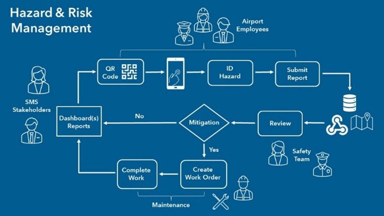
In the US, airports are now mandated by the Federal Aviation Administration (FAA) to have formal Safety Management Systems (SMS) to identify, track, mitigate and manage safety risks, and assure the effectiveness of risk controls. In 2023, FAA FAR Part 139 was updated to include new requirements for SMS for airports certificated under Part 139. These airports must develop and implement an SMS program to identify and quantify potential hazards and risks and adopt processes to manage them. Esri is working with these airports in the US to help them meet this mandate with a suite off-the-shelf web-based applications focusing on the four functional components of SMS:
- Policy
- Risk Management
- Assurance
- Promotion
Esri’s SMS solution is bundled into a series of web pages built using ArcGIS Hub. Along with Dashboards that show the location of safety observations and the status of mitigation efforts, the solution includes a set of safety reporting surveys. Leveraging Survey123, these surveys are used by employees to quickly report safety issues. These reports are automatically routed to safety teams so they can evaluate their severity and likelihood of recurrence. The tools also support individuals who conduct safety reviews, assign, track, and oversee mitigation efforts.

Ensuring Airspace Safety
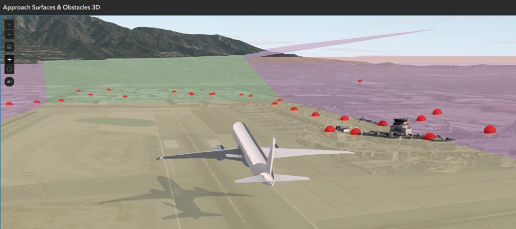
The foundation of smart airports lies in the construction and maintenance of authoritative datasets that capture airport infrastructure, seamlessly integrated with your enterprise GIS. It’s crucial to recognize that airports stretch beyond their property lines, necessitating vigilant management of obstruction risks to ensure safe air travel. ArcGIS Aviation Airports empowers airport authorities to effectively manage Electronic Terrain and Obstacle Data (eTOD), enabling the creation of 3D surfaces that enhance obstacle analysis. This functionality is vital for identifying potential hazards that could interfere with flight operations.

Furthermore, the platform facilitates the design and management of airport signs and markings, allowing users to compare them against reference data to uphold safety standards. By leveraging detailed airport basemaps, dynamic 3D visualizations, and comprehensive operational support content, stakeholders are equipped to make well-informed decisions that enhance airport safety and efficiency.

The Importance of Airport Regulatory and Safety Management
The need for robust, adaptable, and smart solutions for airport safety and security has never been more critical. The integration of GIS in airport operations not only enhances real-time response capabilities but also ensures compliance with regulatory frameworks like the FAA’s Safety Management System mandate. From improving emergency response times to streamlining passenger flow and resource management, GIS-driven smart airports are paving the way for a safer and more efficient future in aviation. As technology continues to evolve, airports worldwide will increasingly rely on these advanced tools to address the complex challenges of modern air travel.
Find more information and contact us via the following web pages:

Commenting is not enabled for this article.