Over the past year, the Living Atlas team has made many updates and enhancements to World Imagery. We continue to add high resolution aerial imagery with contributions made through our Community Maps program and high resolution global satellite coverage from Maxar. As we make updates, the World Imagery Wayback archive continues to grow and we continue to add capabilities.
Community Maps Updates
For over a decade, Esri has maintained a Community Maps Program through which our user community has shared their local, authoritative data with Esri to be used in maps and services that we create and host for our users. Imagery contributions come from local and national mapping agencies around the world and through Esri distributors and partnerships. One notable set of community contributions this past year came from our well integrated Esri Gold Partner, Nearmap. Our collaboration with Nearmap helps to enhance visual and spatial analysis for better decision making, smarter planning, and more effective infrastructure management.
Each of the Nearmap 7.5 cm updates highlighted in the gallery below can be found in the World Imagery basemap.


You can also click on the links below to see the imagery before and after the updates in the World Imagery Wayback app:
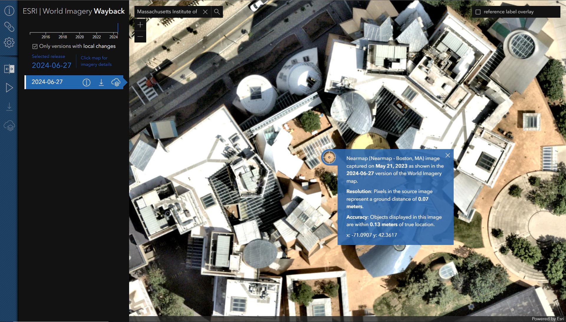
Cambridge/Boston, MA, USA
Austin, TX, USA
Baltimore, MD, USA
Columbus, OH, USA
Redlands, CA, USA
Maxar Updates
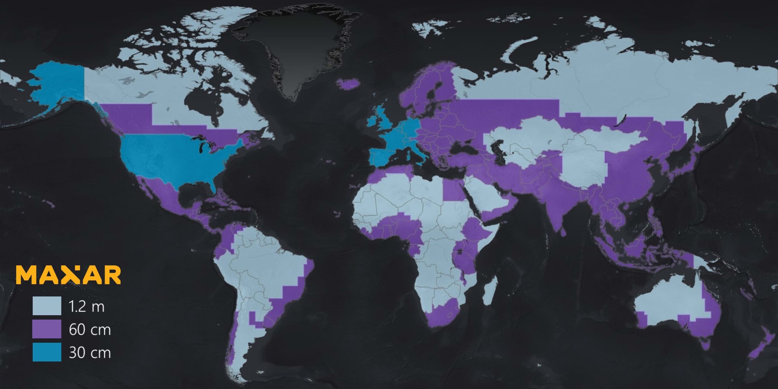
Esri’s subscription to the Maxar Vivid Imagery Basemap includes annual 15 cm to 1 m global updates: 15 cm for select cities, 30 cm for 1,000+ metropolitan areas, and 60 cm+ imagery for the rest of the world. Below is a coverage map showing the total global coverage. The vast majority of the world’s population is covered with 60 cm or better imagery.
World Imagery Wayback
Best thing since sliced bread? Maybe…
Wayback is an archive of the World Imagery basemap. The Wayback app is how you can discover all versions of World Imagery published since 2014. Each version is global, however, the entire world is not typically updated with each version. The app will show you all of the versions that changed at your area of interest. Pan and zoom to your location of interest and you will be presented with a list of change dates (changes are based on both location and level of detail). Click on the map to see the date of acquisition for the imagery displayed.
You can also export tile packages from the Wayback. For years, ArcGIS users have been able to export tile packages from the standard World Imagery map. However, you now export tiles from any version of World Imagery available in the Wayback archive to support your offline workflows within ArcGIS. See World Imagery Wayback Export.
Road Ahead
If you have stuck around this long, congrats. Ever considered running one of the Living Atlas pretrained deep learning models with World Imagery? Well, World Imagery tiles will soon be available for analysis. Stay tuned in the coming weeks for more updates on how to accomplish this within ArcGIS.
Kudos to the Team!
World Imagery Production and Curation: Jim Mason, Chris Egle, Atif Zafar, and Team
Wayback System Architecture: Dr. Lucian Plesea
App Development: Jinnan Zhang
AppUI/UX: John Nelson

Article Discussion: