We are excited for you to join us at this year’s 2024 Esri User Conference, July 15-19 in San Diego, California. As you plan your attendance for the mappiest week of the year either in person or virtually, check out the following resources to find all things ArcGIS Living Atlas of the World and Ready-to-Use Content.
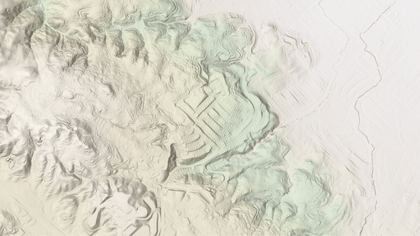
If you’re new to ArcGIS Living Atlas, it is the largest digital repository of spatial content in the world, and it is built directly into ArcGIS. This massive collection of ready-to-use content is designed to kickstart your workflows, and provide authoritative content that can be trusted. There are many beginner technical sessions and demo theaters at the UC designed to help get you started with Living Atlas.
If you’re already familiar with Living Atlas, there are intermediate sessions, new resources, new content, and updates valuable to your workflows. There are also demo theaters containing tips and tricks that you won’t want to miss.
This year’s theme for the conference, GIS – Uniting Our World, focuses on the common language of geography and collaboration. This is at the core of what Living Atlas has to offer, containing spatial content BY the GIS community FOR the GIS community.

Find Living Atlas in the UC Expo
Visit us at the showcase to learn more, ask questions, talk with subject matter experts, or see demos of the latest content available within Living Atlas. Esri curators are available to discuss how you can nominate your own content, making your information more accessible to GIS communities worldwide. Find us near Demo Theater 11 next to ArcGIS Online and Spatial Analytics.
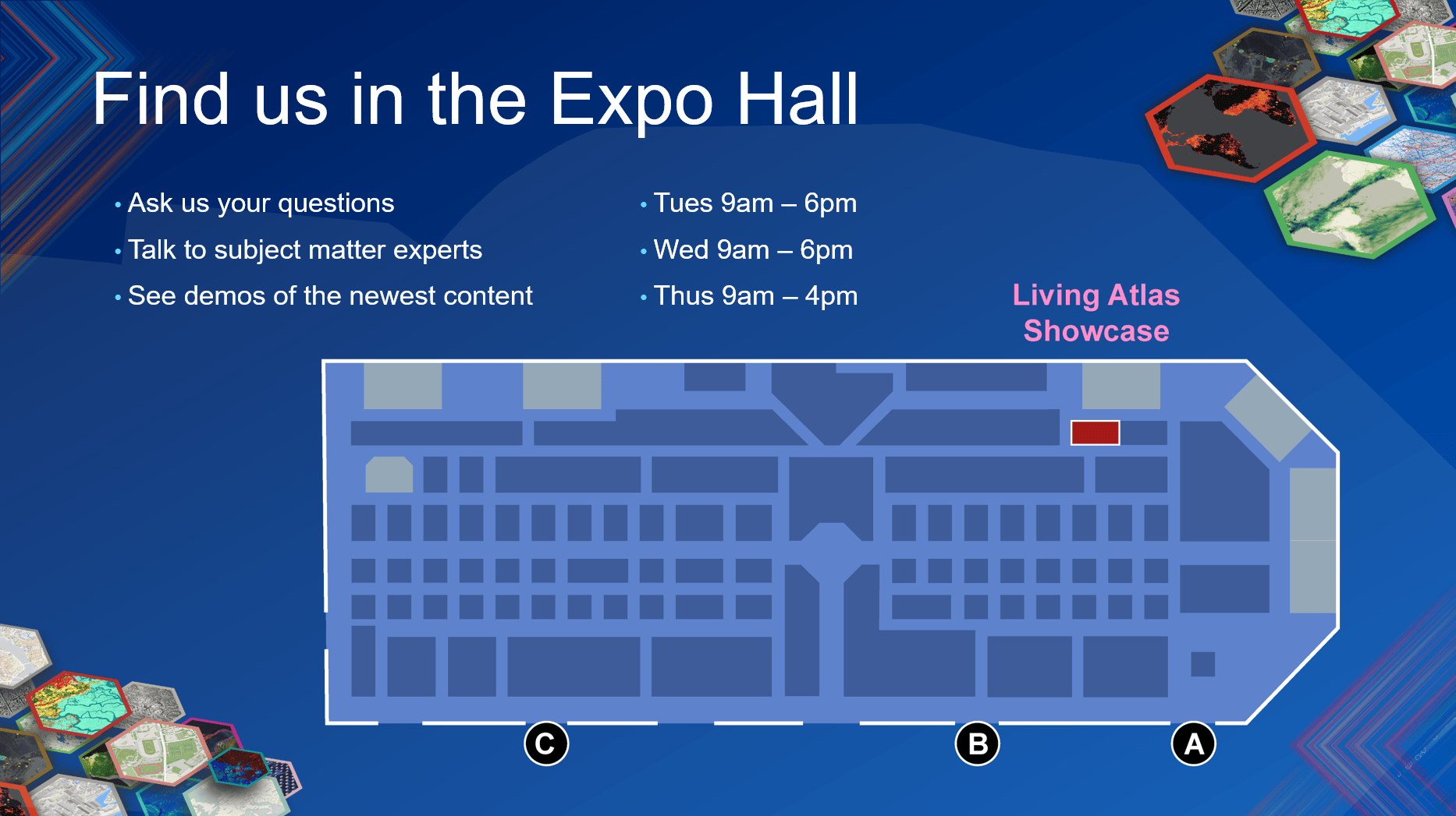
Showcase Hours
- Tuesday, July 16, 9 am–6 pm PT
- Wednesday, July 17, 9 am–6 pm PT
- Thursday, July 18, 9 am–4 pm PT
Attend Living Atlas Sessions
As you plan your busy week, check out the sessions highlighting Ready-to-Use Content. We have Beginner and Intermediate sessions to help you learn more about topics like Imagery, Basemaps, Sustainability, Open Data, Demographics, Community Maps, Policy, and so much more. These sessions presented by subject matter experts provide best practices and technical demonstrations of the latest content within Living Atlas.
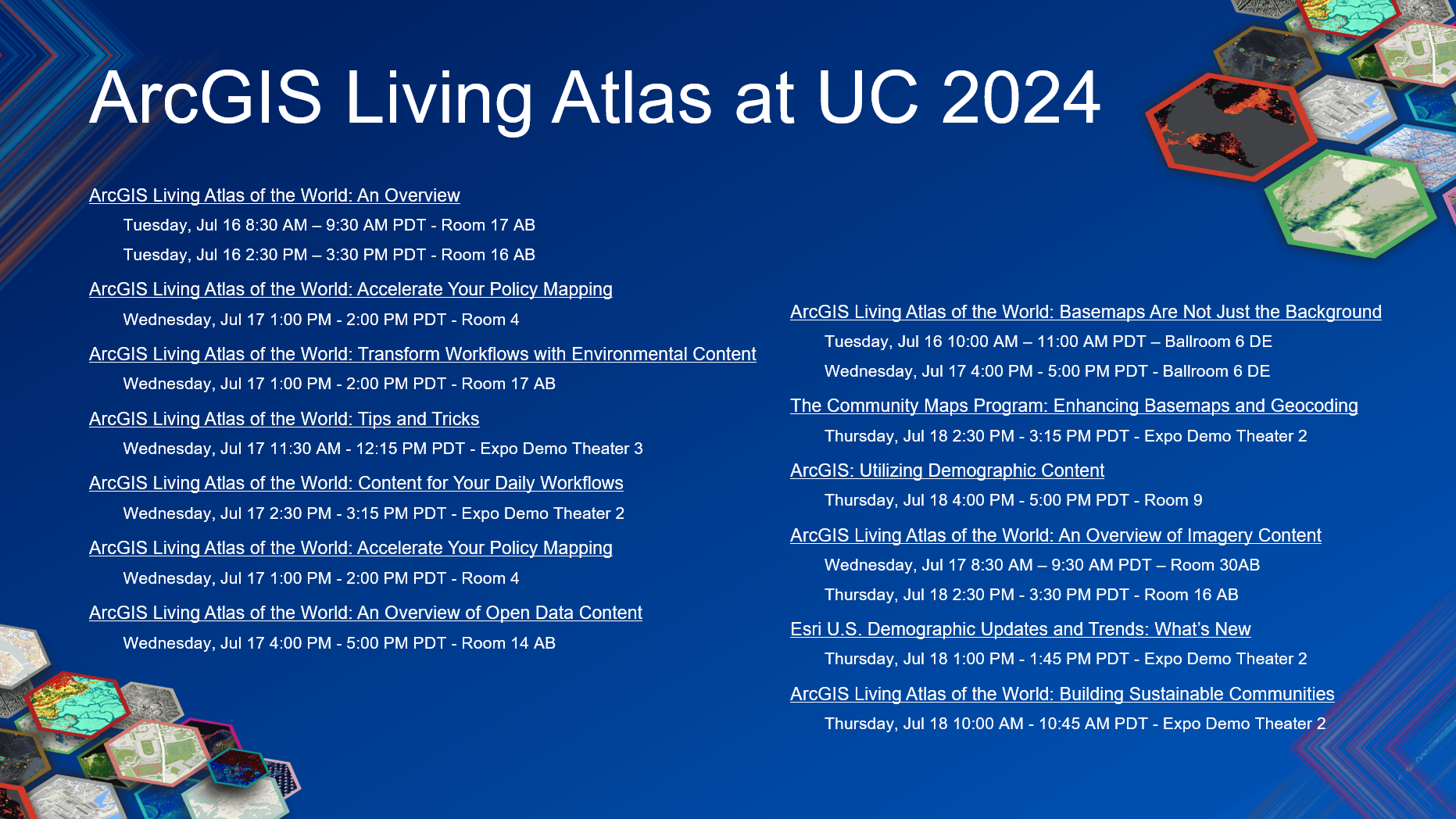
ArcGIS Living Atlas of the World: An Overview (Live stream session)
Discover the world’s foremost collection of geospatial information! ArcGIS Living Atlas of the World curates ready-to-use maps, apps, and layers from Esri and the global GIS user community. Presenters showcase recent additions and updates to ArcGIS Living Atlas. Find out how to use ArcGIS Living Atlas content to support your work across the ArcGIS system as well as how to share your work in ArcGIS Living Atlas.
Tuesday, Jul 16 8:30 AM – 9:30 AM PDT
Tuesday, Jul 16 2:30 PM – 3:30 PM PDT
ArcGIS Living Atlas of the World: Basemaps Are Not Just the Background
Basemaps are the foundation for your maps and apps, but they are also part of the story that you are telling. Discover the integral role that basemaps play in developing your maps, and learn about available options through ArcGIS Living Atlas and how to choose appropriate basemaps. Explore how to use tools in ArcGIS Pro and Map Viewer to build your own basemap versions with the ArcGIS Vector Tile Style Editor.
Tuesday, Jul 16 10:00 AM – 11:00 AM PDT
Wednesday, Jul 17 4:00 PM – 5:00 PM PDT
ArcGIS Living Atlas of the World: An Overview of Imagery Content (Live stream session)
Are you new to imagery or looking for ways to leverage raster analysis? This presentation discusses the fundamentals of ready-to-use imagery in ArcGIS Living Atlas of the World as well as the various types of imagery available and how to access them. Learn about a variety of available sources and best practices for using ArcGIS Living Atlas imagery in various workflows, custom apps, Map Viewer, ArcGIS Pro, and ArcGIS Notebooks.
Wednesday, Jul 17 8:30 AM – 9:30 AM PDT
Thursday, Jul 18 2:30 PM – 3:30 PM PDT
ArcGIS Living Atlas of the World: The Geographic Approach (Live stream session)
The Geographic Approach is a way of thinking and problem-solving that integrates and organizes all relevant information in the crucial context of location. This presentation guides you through the basics of applying the Geographic Approach to your GIS workflows while providing valuable resources. Utilize ready-to-use content from sources like ArcGIS Living Atlas of the World to summarize information, visualize the results, and communicate the findings to your end audience.
Wednesday, Jul 17 10:00 AM – 11:00 AM PDT
ArcGIS Living Atlas of the World: Tips and Tricks
Are you using ArcGIS Living Atlas of the World to its full potential? With ArcGIS Living Atlas, you have access to spatial content that is available for use in ArcGIS Online and ArcGIS Pro, among other common GIS workflows. Join us to learn some tips and tricks to implement in your work when using ArcGIS Living Atlas. Go beyond the basics to customize layers, maps, and apps for your needs. See best practices for improving your existing workflows, both analytically and cartographically. Save time and kick-start your GIS workflows by using the power of ArcGIS Living Atlas and the Geographic Approach.
Wednesday, Jul 17 11:30 AM – 12:15 PM PDT
ArcGIS Living Atlas of the World: Accelerate Your Policy Mapping
Join us to see how to transform a map of data into a policy map. Policy maps create understanding about topics like equity and access, provide a human context to existing and proposed infrastructure, and track progress over time. A policy map answers a specific question and inspires several more, such as the following: What is the current situation? How has it changed over time? Which areas have the greatest need? Which actions are proposed, and where? How do you track the impact on the local community? In addition, learn which types of policy maps are needed at each stage of a policy’s life cycle. You will learn about ready-to-use information in ArcGIS Living Atlas of the World that can help to expedite your policy mapping project.
Wednesday, Jul 17 1:00 PM – 2:00 PM PDT
ArcGIS Living Atlas of the World: Transform Workflows with Environmental Content
Enrich your own data with ready-to-use global environmental content available in ArcGIS Living Atlas of the World. Learn how to access and explore content, utilize the latest analysis tools to address critical environmental issues, and use cartographic and visualization best practices to produce clear, understandable, and sharable maps for your audience.
Wednesday, Jul 17 1:00 PM – 2:00 PM PDT
ArcGIS Living Atlas of the World: Content for Your Daily Workflows
ArcGIS Living Atlas of the World offers diverse spatial content, all ready to use in your GIS workflows! Learn techniques for navigating ArcGIS Living Atlas and for using the key categories of content available in this ever-growing collection: basemaps, environment, people, infrastructure, and boundaries.
Wednesday, Jul 17 2:30 PM – 3:15 PM PDT
ArcGIS Living Atlas of the World: An Overview of Open Data Content
Get acquainted with some of ArcGIS Living Atlas of the World’s most useful datasets, including global data sources such as OpenStreetMap and Overture Maps. ArcGIS Living Atlas includes a large and growing collection of open data layers that can be easily accessed in ArcGIS and used to create maps, perform analysis, and generate derivative datasets and services. Learn how to access this data through ArcGIS to create maps and apps for use in your work and share with the public as well as how to share your own authoritative data.
Wednesday, Jul 17 4:00 PM – 5:00 PM PDT
ArcGIS Living Atlas of the World: Building Sustainable Communities
See how you can use GIS to address sea level rise in coastal communities. This presentation demonstrates an example workflow: identifies at-risk infrastructure; utilizes tax assessment information to quantify economic sustainability; uses population data to measure impacts; and prioritizes impacts to implement a resiliency plan. In addition, learn how 3D resources can help to describe the impacts of sea level rise to community members.
Thursday, Jul 18 10:00 AM – 10:45 AM PDT
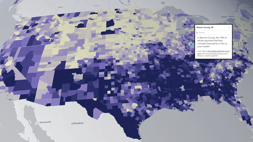
Esri U.S. Demographic Updates and Trends: What’s New
Learn what’s new in the latest U.S. update for Esri Demographics. Presenters introduce new data, measures, and tutorials for the 2024-2029 data release and show how you can get started working with it. Hear from Esri’s chief demographer, who shares annual observations of current demographic trends in the United States.
Thursday, Jul 18 1:00 PM – 1:45 PM PDT
The Community Maps Program: Enhancing Basemaps and Geocoding
Learn how to maximize your basemaps and also elevate your geocoding results. Address data is the fuel for geocoding services, and features are the fuel for Esri basemaps. Learn how you can benefit from joining the Community Maps Program and sharing addresses and features. This presentation highlights tools and data and how the Community Maps Program can make your world better.
Thursday, Jul 18 2:30 PM – 3:15 PM PDT
ArcGIS: Utilizing Demographic Content
Whether you work in ArcGIS Online or ArcGIS Pro and whether you are a GIS expert or beginner, there is something for everyone in this technical session. Get tips and tricks to make demographic data shine in ArcGIS. Learn how to find, apply, and visualize ready-to-use demographic content from Esri Demographics, the U.S. Census Bureau, and global statistical agencies for your analyses and workflows.
Thursday, Jul 18 4:00 PM – 5:00 PM PDT
Need Living Atlas support before or after the UC?
Visit the Living Atlas website for the latest news on what’s new.
See if your question is answered in this blog: Your Living Atlas Questions Answered.
Join the conversation at the Living Atlas Esri Community page.
It’s Not Too Late to Register for UC 2024
Register today to attend in-person, virtually with digital access, or for the plenary only. We look forward to seeing you in-person in San Diego or online and wish you a wonderful User Conference 2024!
Join the plenary session on Monday July 15, 2024 to explore why a holistic, location-based understanding of our world can both unite and empower us to affect positive change. You’ll see Living Atlas in many of the plenary demos, by both Esri users and Esri staff. Try to count how many times you see or hear Living Atlas referenced on stage this year!


Article Discussion: