Two years ago, Esri introduced a new set of OpenStreetMap (OSM) 3D scene layers that could be used for 3D visualization. One year ago, we introduced a new set of 3D Basemaps referencing these scene layers that were added to the basemap gallery for 3D ArcGIS apps such as Scene Viewer and ArcGIS Pro. These 3D scene layers and basemaps have been built with open data from the OSM Daylight Distribution and take advantage of the 3D mapping that has been performed by the OSM community, plus some important enhancements from the team maintaining the OSM Daylight Distribution.
This year, we are excited to introduce some enhancements to the 3D layers that will be used in our 3D Basemaps. Esri has been working with our partners (i.e. Maxar Intelligence and TomTom) to acquire and prepare some high-quality commercial data to supplement the open data that is available. This includes selected Maxar Precision3D data and TomTom MultiNet 3D buildings, which are being used to enhance the layers in our 3D Basemaps.
More Precise 3D Elevation
The foundation layer of a 3D basemap is the terrain surface. Esri’s Terrain 3D elevation layer is compiled from a variety of best-available open, commercial, and community data sources at multiple levels of resolution. We recently updated the Terrain3D and TopoBathy 3D layers to include the first rollout of Maxar Precision3D data. The Precision3D Digital Terrain Models (DTM) at 50 cm resolution are created by pairing Maxar’s extensive archive of high-resolution satellite imagery with the company’s patented 3D technology.
This high-resolution DTM data greatly improves the visual appearance and spatial accuracy of 3D Basemaps in many parts of the world, such as in the example below. Please visit this recent blog article by my colleague Rajinder Nagi to see several more examples of these enhancements, and learn more about the elevation layer updates.

More Accurate 3D Buildings
The latest release of the OSM Daylight Distribution includes over 1.4 billion buildings around the world. Many of these buildings have been beautifully mapped with 3D attributes by the OpenStreetMap community. However, only a small percentage of all the OSM building footprints include 3D attributes, such as height or levels. The OSM Daylight Distribution includes heights and estimated heights for several million additional buildings from other sources but still most buildings do not have accurate 3D attributes, especially outside of North America and Europe.
To help improve this, Esri is using 3D buildings data acquired from Maxar and TomTom, as well as Esri Community Maps Contributors, to publish a new Esri 3D Buildings scene layer. The new scene layer is currently in beta release and includes the first rollout of 3D buildings data for large parts of the world. The scene layer includes hundreds of millions of multi-part buildings with more accurate 3D attributes, which supports better visualization and client-side analysis. You can compare the OSM and Esri 3D buildings in the examples below.
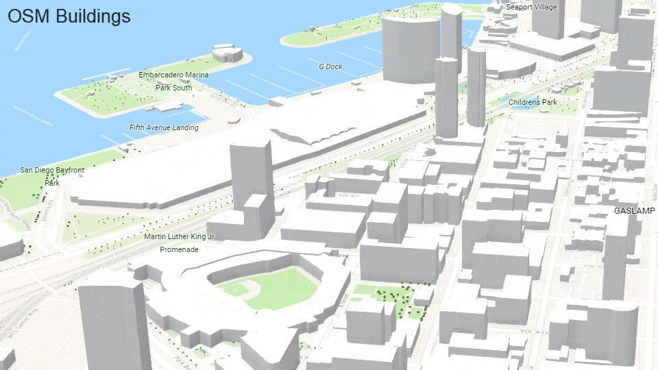
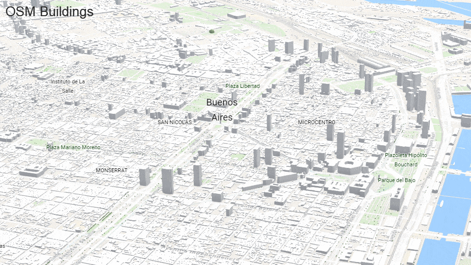
You can view this web app to see several more locations around the world showing both the OSM Buildings and Esri Buildings scene layers for comparison purposes.
What’s Next
Over the next few months, we will be expanding the coverage of the buildings in the Esri 3D Buildings scene layer. This will include more commercial, community, and open buildings data. For the open buildings, we will begin to use buildings from the Overture Maps buildings theme, which is moving into General Availability release soon.
If you are a member of the GIS Community and would like to help enhance the new 3D basemaps, you can share your 3D buildings through Esri Community Maps. After we review and accept the buildings, we will integrate them into one or both of our buildings scene layers so that you and others can use them for your 3D mapping.
Learn More
To learn more about this work, please join us at the Esri User Conference if attending in person (or digitally) this year. Join us at:
- Technical Session
- Expo: ArcGIS Living Atlas Area in the Esri Showcase
- Visit Basemaps, Elevation, and Community Maps kiosks to meet the team!

Article Discussion: