ArcGIS Solutions helps you make the most of your GIS by providing purpose-driven, industry-specific configurations of ArcGIS.
As long as the lights are on and the fridge is running, the average person doesn’t give much thought to the purpose of a utility pole. But utility poles carry a heavy and important load: Not only do they support overhead power lines, but, through joint-use partnerships, they can also carry cables for high-speed internet, broadband expansion, and communications networks.
There are a lot of moving parts when different organizations share infrastructure, but managing joint-use activity doesn’t have to be complicated. In fact, our Electric Joint Use solution is specifically designed to meet the needs of electric utilities, with capabilities that help streamline the joint-use approval process, build an authoritative joint-use inventory, and manage joint use-affected pole replacements.
Spark
GVEC is a cooperative that delivers electricity, high-speed internet and beyond-the-meter services to more than 120,000 customers, with a service area that spans 3,500 square miles over 13 counties in south central Texas. Like many utilities, GVEC manages the joint use of its utility poles. For years, attaching companies would email their requests and documentation to GVEC’s joint-use coordinators, and the coordinators would respond in kind.
But tracking permit status by email was inefficient and required multiple rounds of back-and-forth between coordinators and attachers as they sorted out the details. Which permits are open? Are we missing any information? Where is the email with the form attached?
GVEC had been looking for a solution to their joint-use workflow issue for a while when they found Esri’s Electric Joint Use solution. They knew it was exactly what they were looking for and immediately deployed it.
Power up
GVEC’s permitting process is much simpler and faster now. Attachers submit requests via the utility’s Electric Joint Use ArcGIS Hub site, specifying the first pole that they want to attach to and documenting the numbers associated with poles that will carry additional attachments.
The Electric Joint Use solution has helped with the modernization of the joint-use process and provided efficiency in our processes.
The utility’s joint-use coordinators then verify that the required documentation is complete and determine if there will be a make-ready cost associated with the request. If so, they add the cost to the request. The solution enabled GVEC to configure email notifications; when a make-ready cost is added or the request is otherwise updated, attachers are immediately notified. And when the attacher approves the cost—also through the Hub site—GVEC is informed and can schedule repairs.

Accelerate
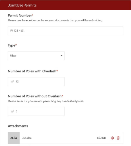
Electric Joint Use, like most of our solutions, can be modified to fit an organization’s needs. GVEC, for example, already has a specific permit numbering system in place and did not want the request form to autogenerate one. Therefore, analysts added a field where attachers could type the permit number that matched their attached documentation. They added fields for attachers to document how many poles would be with or without overlash and changed the form to allow for multiple attachments to be submitted with each request.

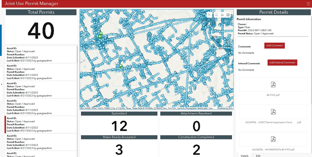
But one of the most significant ways that Electric Joint Use has helped GVEC is allowing the data analytics team to track the total number of active and approved permits. The team and the utility’s executives had been interested in tracking the location of their joint-use attachments. Now, they can view this information and even pull past attachment data, information especially useful for internal reporting and future planning.
The Electric Joint Use solution was easy to set up and customize to fit our needs.
“It has been powerful to see where the majority of our attachments are located and what patterns have emerged,” says GIS analyst Henrietta Krellenstein. “A clear trend of the attachments being located on the eastern side of our territory was displayed in the data.”
Energize
The Electric Joint Use solution has had other benefits as well. The utility’s GIS analysts and technicians were thrilled to introduce the power of GIS to their coworkers, demonstrating what it can do and how it can be used to quickly and easily display complex spatial data on a comprehensive dashboard. Now, permitting and project coordinators—many of whom had never used GIS products before—regularly work with the solution and all the ArcGIS products it incorporates: Dashboards, Survey123, Notebooks, and Field Maps, to name a few. Now that’s powerful!
Learn more
For more information about the Electric Joint Use solution, check out the following resources:
- Learn how to deploy, configure, and use the solution.
- View a demo video.
- Learn more about ArcGIS Solutions.


Article Discussion: