The December 2023 update is here with significant quality enhancements, bug fixes, and new tools to explore.
The following sections detail these updates, per component.
ArcGIS for Excel
The following are updates to ArcGIS for Excel:
- To improve the user interface, icons have been updated on the ArcGIS tab, as well as across the software.

- In the Layers pane, when you add data from Microsoft Excel, automatic selection of x,y data is now supported. When you select a cell in a Microsoft Excel table, the data is smart mapped and can detect x,y information. The Data field by default selects the entire table, but you can always select a specific cell range from the drop-down menu.
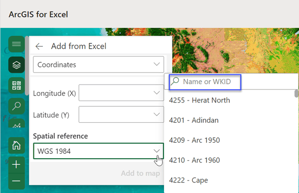
- More options are available for Well Known IDs (WKID) in the Spatial reference drop-down menu when adding data from Excel.

- You can create and share custom printable templates for your organization. When signing in to ArcGIS for Excel with ArcGIS Enterprise, custom print templates are now available in the Print pane.
- Geocoding capability is now available in the Function Builder. Use the following functions to geocode address lists in a Microsoft Excel worksheet—GETADDRESS, GETCOORDINATES, and SUGGESTADDRESS.
- In addition to zoom in and zoom out navigation, you can now return to the default map view and expand a map to use the full screen.

- A question addressing how to clear your cache and others are answered in the updated FAQ topic.
ArcGIS for SharePoint
- ArcGIS for SharePoint now supports geocoding a Microsoft SharePoint list or document library within the SharePoint interface to streamline your workflows. To spatially enable a list or library for mapping, select rows in your list, click the new Geocode button from the toolbar, and select your desired geocoder from the Geocode menu. You can still geocode a list or library using the Power Automate template to spatially enable your list or library for mapping.
- When adding data to a map, geotagging, or geosearching, you can now search for data throughout available SharePoint hub sites in addition to root sites and subsites using the Site picker.
- List map has been renamed to Edit locations. Open a SharePoint list or document library, click Edit locations, and precisely edit or delete points, polylines, or polygons.
- Enhancements have been made throughout the UI. For example, pop-ups, which previously showed images as the image path and links as plain text, now display image thumbnails and hyperlinked links.
- Several bug fixes have been made, including a bug that previously prevented dynamic filtering between connected web parts and a bug that prevented re-editing a page after it had been published with a map.
- Icons have been updated across the software.
Additional resources
You can read the latest blog articles, interact with experts, take a survey, learn about ArcGIS for Microsoft 365 components, get peer-to-peer feedback, and find answers to software questions on the Esri Community site.
Visit the video site, new product page, and ArcGIS for Microsoft 365 Esri Community pages for the latest change logs and blog articles:


Article Discussion: