Do you remember what happened in February this year? It seems like such a long time ago, so we won’t hold it against you if you’ve forgotten that that’s when ArcGIS Pro 3.1 was released. After months of development, we’re excited to share what’s new in the latest version – ArcGIS Pro 3.2. This release is packed full of much anticipated features and functionality along with some great performance, productivity and quality improvements. There are literally hundreds of new things to try, with more than 100 user ideas implemented from the ArcGIS Pro idea exchange alone.
With so much that’s new, there is bound to be something for you but where should you start? Check out the release highlights for ways to improve how you manage, explore, and visualize data in maps through new and meaningful ways.
- Document and Navigate Your Geodatabase Data Model
- Efficiency at Your Fingertips with Improvements to Keyboard Shortcuts
- Create Engaging Thematic Map Series
- Enhanced Data Storage with Four New Field Data Types
- Gain New Perspectives with Oriented Imagery
- Elevate Your Mapping Projects with 3D
- Take Control of Your Editing Experience
- Organize and Streamline Your Project’s Visual Elements
OR Watch the What’s New video, then jump right in!

Release Highlights
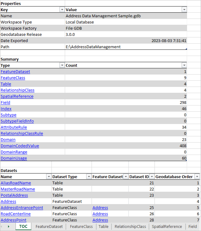
Document and Navigate Your Geodatabase Data Model
If you’re a fan of the X-Ray for ArcCatalog add-in, this tool is for you! Create a comprehensive document of your geodatabase data model with the Generate Schema Report tool. Produce a report including datasets, relationships, rules, and properties, providing a complete schema overview. With the ability to export in multiple formats, such as Excel, JSON, HTML, and PDF, you can easily collaborate on proposals, gather stakeholder buy-in, assist in data migration, and use it as a data dictionary. The report’s hyperlinks enable quick navigation and exploration of your schema elements, making finding the information you need effortless. For more on the latest new features, enhancements and tutorials to help you with managing your data in ArcGIS Pro, check out the new Geodatabase Resource Hub.
Efficiency at Your Fingertips with Improvements to Keyboard Shortcuts
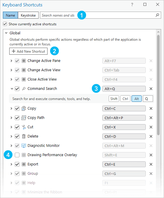
The completely new keyboard shortcuts dialog let’s you search for default shortcuts, modify existing ones, and add new shortcuts to suit your specific needs. “How is that different than the global keyboard accelerators I’ve used in ArcGIS Pro for years?” you may ask. The new keyboard shortcut framework supports contextual shortcuts; that is, you can re-use the same shortcut when different parts of the application are active. For example, you may want Ctrl+S to save the project when you’re working in a map view, but you may also want Ctrl+S to save edits when you’re working in the attribute table. Now you can do that!
The dialog box includes warnings to alert you if the same shortcut is assigned to conflicting commands, ensuring a smooth and error-free experience. Take control of your productivity by utilizing customizable Keyboard Shortcuts in this efficient and user-friendly environment.
| Feature | Description |
| 1 | Search for shortcuts by command name or keystroke |
| 2 | Browse to commands for which you want to add shortcuts. |
| 3 | Assign different keystrokes to existing shortcuts. |
| 4 | Turn off shortcuts to deactivate them. You can also delete shortcuts. All modifications can be reset to default values. |
Create Engaging Thematic Map Series
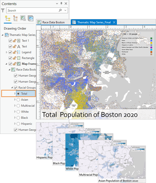
Get ready to captivate your audience with the new thematic map series feature. Create visually stunning and informative map series where the map frame remains consistent, while the data within the map updates on each page. Imagine the possibilities!
Highlight different layers or groups of layers in your map, providing a dynamic visual representation of your data that tells a compelling story. How does it work? By seamlessly iterating through features in a radio group layer, each page of the map series showcases a different layer, while keeping the extent unchanged. This means that only one layer from the radio group is visible on each page, while other layers in the group remain hidden, ensuring a clean and focused presentation. And don’t worry, layers outside the radio group remain visible throughout the entire map series, providing context and continuity.
Enhanced Data Storage with Four New Field Data Types
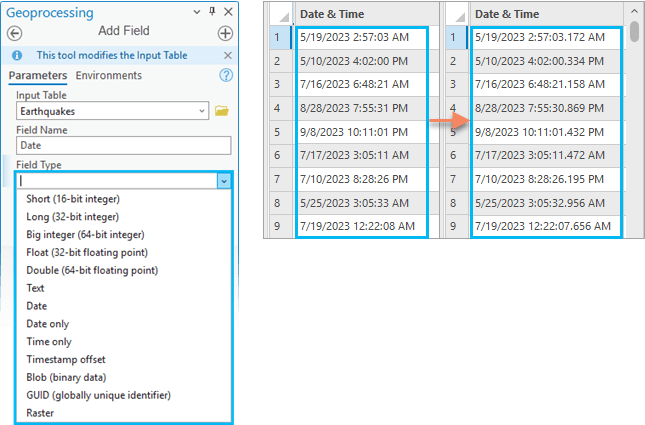
Get ready to improve your data storage capabilities with four new field data types in ArcGIS Pro – plus 64-bit Object IDs. These cutting-edge data types offer unparalleled flexibility and precision, enabling you to store and analyze your information with the utmost accuracy. The new field types are available when creating new tables or feature classes, in the Fields view, or through geoprocessing tools like Add Field.
Let’s explore:
- Big integer: Say goodbye to limitations! Store large whole numbers beyond the range of the long integer data type.
- Timestamp offset: Store date and time with an offset from coordinated universal time (UTC), perfect for managing time zone information.
- Date only: Capture dates without time values, ideal for tracking birth dates, vacation periods, or school years.
- Time only: Focus on the clock! Store time values without dates, making it a breeze to manage business hours, transportation schedules, and more.
And to round out the date-time improvements, the Migrate Date Field To High Precision geoprocessing tool allows you to migrate data to high precision date fields that support millisecond time.
Gain New Perspectives with Oriented Imagery
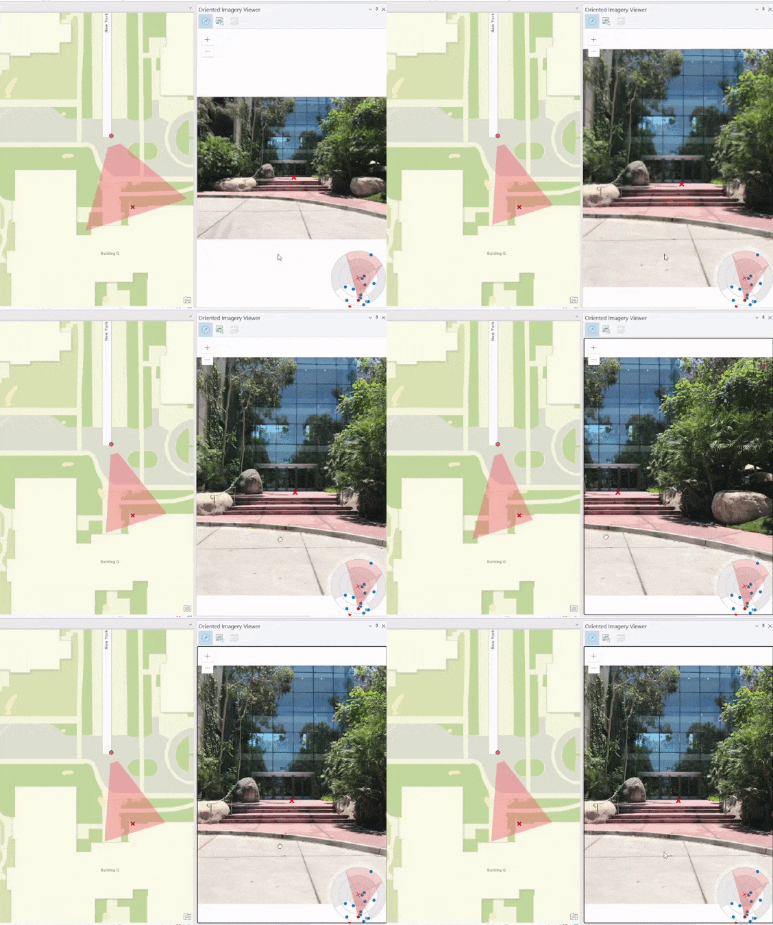
Introducing oriented imagery in ArcGIS Pro. A fantastic way to manage, visualize, and explore nontraditional image collections within your maps. ArcGIS Pro handles diverse image types, from oblique and drone imagery to close-range inspections and street-level images.
Utilize the oriented imagery dataset to manage your collection and add it to your map as an oriented imagery layer. Explore the layer using the oriented imagery viewer, clicking on the map to view the best image for any location. Witness dynamic updates of image footprints as you pan and zoom and use the navigation tool or image gallery to explore different perspectives. When you are ready, share your oriented imagery layer for collaboration and analysis.
Elevate Your Mapping Projects with 3D
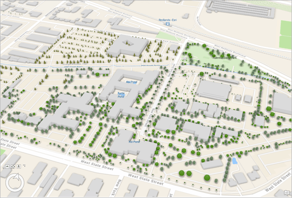
Enhance your ArcGIS Pro scenes by accessing Esri’s new 3D Basemaps from ArcGIS Living Atlas. 3D Basemaps can elevate your scenes with 3D buildings, trees, and labels while visualizing popular vector tile basemaps like Topographic or Community Map. Additionally, with the latest version of ArcGIS Pro 3.2, users can leverage the mesh and 3D object elements of 3D Tiles from local directories or public services. Combine these 3D tiles with other Open Geospatial Consortium (OGC) community standard GIS layers, such as Indexed 3D Scene Layers (I3S), for use in exploration tools, analysis, animation, layouts, and more. With 3D Tiles seamlessly integrated into the ArcGIS 3D system of record, users can elevate their data beyond a realistic visualization by leveraging the analytic power of a complete GIS.
Take Control of Your Editing Experience
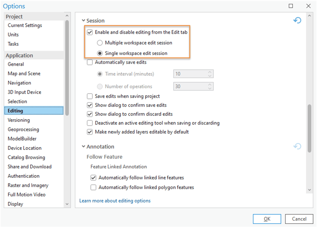
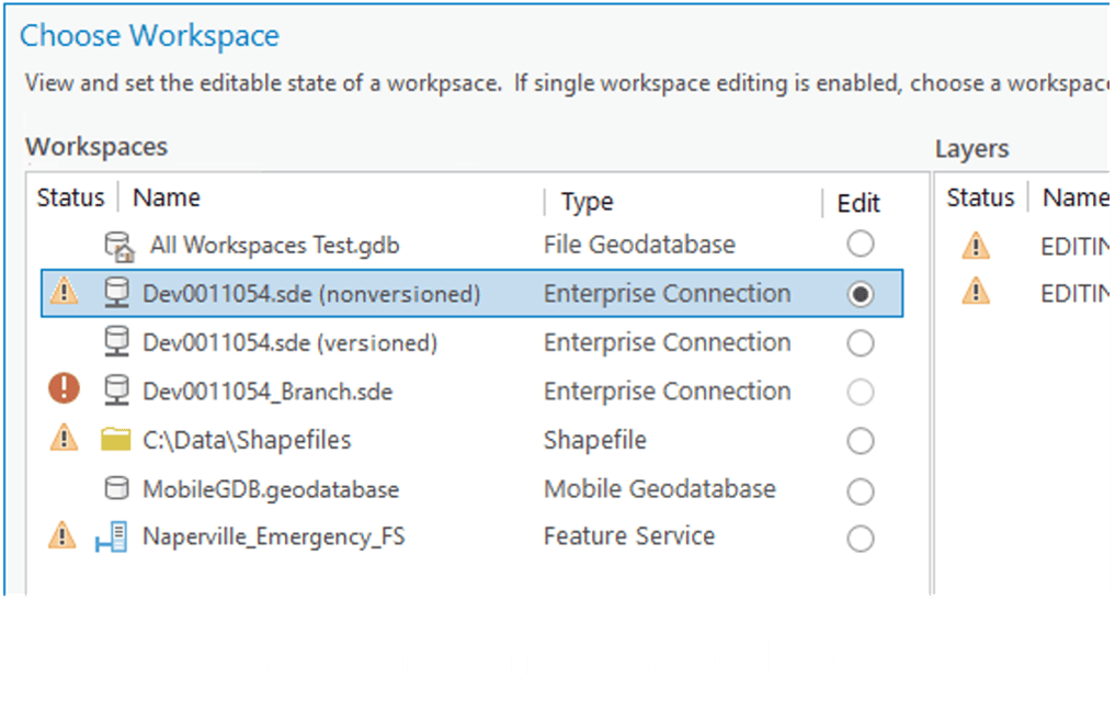
You can customize your editing workflow in ArcGIS Pro. First, you can set edit session options to require manual tool enablement. Then choose between ArcGIS Pro managing workspace edit sessions or manually selecting a workspace. These settings are also available for system administrators to control, giving you complete control over your organization’s editing environment. By running single workspace edit sessions and selecting a non-versioned enterprise geodatabase workspace, you can manually save and discard edits directly from the ribbon’s Edit tab.
Organize and Streamline Your Project’s Visual Elements
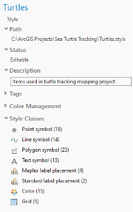
Learn how to save all the style items of a project to a style, effectively organizing symbols, colors, label placements, and layout items used in maps, scenes, layouts, and more. Discover how to categorize and manage these elements, allowing duplicates or streamlining the style to enhance visual consistency. Create a style from your project and share the .stylx file across your organization to more easily generate standardized and consistent-looking map products.

Learn More
Browse the help documentation for a complete list of release highlights.
Attend our Live Training Seminar to discover What’s New in ArcGIS Pro 3.2.
Take your pick from more than 30 short how-to videos (one minute or less) recently added to the documentation. You can find examples related to edits, layouts, working with CAD data, and other ArcGIS Pro workflows.
Whether you’re a seasoned ArcGIS Pro user or just getting started, there is always something to learn. Check out the growing collection of ArcGIS Pro Shorts videos for bite-sized morsels of how-to knowledge! For users migrating from ArcMap to ArcGIS Pro, these videos are a fantastic addition to our quick-start tutorials and come just in time before ArcMap moves into Mature Support on March 1, 2024-meaning no more patches. So be sure to dive in, get your fill of ArcGIS Pro knowledge, and gain new skills to help you make the move. See the Migrate from ArcMap to ArcGIS Pro page for more resources.
Stay tuned for what’s to come in spring 2024! Don’t forget to subscribe to our ArcGIS Pro newsletter to gain access to the latest product news, customer stories, and tips and tricks.



Commenting is not enabled for this article.