To improve the National Spatial Reference System (NSRS) in the United States, the National Oceanic and Atmospheric Administration’s National Geodetic Survey (NGS) is preparing to replace all three current North American Datum of 1983 (NAD83) frames and all current vertical datums, including the North American Vertical Datum of 1988 (NAVD88), with four new terrestrial reference frames and a vertical geopotential datum. These new reference frames will be easier to access and maintain than the current NSRS, which relies on physical survey marks that deteriorate over time. Complete information about the NSRS modernization can be found on the NGS website. NGS is currently doing a “phased roll-out and testing” of the modernized NSRS. Some preliminary products are available at the NGS Alpha Product Release Site. The official release of NSRS 2022 is not expected before 2026 (see the NSRS Modernization News, Issue 36).
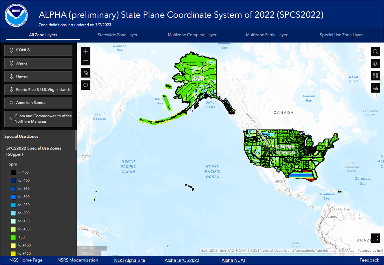
The State Plane Coordinate System of 2022 (SPCS2022) will also be part of the modernized NSRS. The NGS has released a preliminary (alpha) version of SPCS2022. The NGS currently estimates 972 new SPCS definitions, including statewide zones and zones for special use that encompass more than one state. All definitions will be based on meters and international feet as the linear units. The official release of SPCS2022 will occur in 2026, along with other parts of the NSRS. You can explore the preliminary zone designs in the Alpha SPCS2022 online interactive map.
Here at Esri, we have been attending NGS conferences and webinars since the modernization effort was first announced. ArcGIS software will support the new reference frames as well as associated new State Plane zones and transformations that will accompany these new frames. We are testing and preparing our software as preliminary information is released by the NGS.
In the past, we have made preliminary definitions available in our software based on customer requests. Unfortunately, this impacted compatibility between releases due to changes in the final definitions. Note that we will not be adding any preliminary NSRS 2022 definitions in ArcGIS software until the official release in 2026.
How to prepare for these datum changes in the meantime
To prepare for the NSRS modernization, the NGS advises users (see the New Datums Are Coming flyer) to transform data in historic coordinate systems (NAD27, NAD83, HARN, NGVD29, and so on) to the latest NSRS datums and realization, that is, NAD 1983 (2011) Epoch 2010.0 and NAVD88. To facilitate these transformations, the NGS released the NGS Coordinate Conversion and Transformation Tool (NCAT) and NADCON 5.0 transformation grids.
ArcGIS Pro, ArcGIS Enterprise, and ArcGIS Desktop (ArcMap) already include all definitions for NADCON 5.0 transformations since ArcGIS Pro 2.6 and ArcGIS 10.8.1. To activate these transformations, users need to install the ArcGIS Coordinate Systems Data software component on their computer, which includes the necessary transformation files. Similarly, ArcGIS Maps SDK distributes these files as Projection Engine data.
The correct way to convert data in historic U.S. datums is to transform them through all in-between NAD83 datums, that is, from NAD27 to NAD83 (1986) to NAD83 (HARN) to NAD83 (FBN) to NAD83 (NSRS2007) and finally to NAD83 (2011). Transformations should not be performed between unrelated geographic coordinate systems, such as WGS 1984. The NADCON 5.0 transformations listed below are available in ArcGIS Pro (see How to transform data in ArcGIS Pro). The following lists give the order in which transformations should be used:
For Contiguous United States (CONUS)
NAD_1927_To_NAD_1983_7 (WKID::8555)
NAD_1983_To_NAD_1983_HARN_47 (WKID::8556)
NAD_1983_HARN_To_FBN_NADCON5_3D_CONUS_1 (WKID::8861)
NAD_1983_FBN_To_NSRS2007_NADCON5_3D_CONUS_1 (WKID::8862)
NAD_1983_NSRS2007_To_2011_NADCON5_3D_CONUS_1 (WKID::8559)
For Alaska
St_George_Island_To_NAD_1983_2 (WKID::8546)
St_Lawrence_Island_To_NAD_1983_2 (WKID::8547)
St_Paul_Island_To_NAD_1983_2 (WKID::8548)
NAD_1927_To_NAD_1983_8 (WKID::8549)
NAD_1983_To_NAD_1983_HARN_48 (WKID::8550)
NAD_1983_HARN_TO_NAD_1983_NSRS2007_2 (WKID::8551)
NAD_1983_NSRS2007_TO_NAD_1983_2011_2 (WKID::8552)
For Puerto Rico and U.S. Virgin Islands (PRVI)
Puerto_Rico_To_NAD_1983_2 (WKID::8668)
NAD_1983_To_NAD_1983_HARN_50 (WKID::8669)
NAD_1983_HARN_To_HARN_Corrected_NADCON5_3D_PRVI_1 (WKID::9181)
NAD_1983_HARN_Corrected_To_FBN_NADCON5_3D_PRVI_1 (WKID::8867)
NAD_1983_FBN_To_NSRS2007_NADCON5_3D_PRVI_2 (WKID::8868)
NAD_1983_NSRS2007_To_2011_NADCON5_3D_PRVI_3 (WKID::8673)
For Hawaii
Old_Hawaiian_To_NAD_1983_2 (WKID::8561)
NAD_1983_To_NAD_1983_HARN_49 (WKID::8660)
NAD_1983_HARN_To_PA11_NADCON5_3D_Hawaii_1 (WKID::8661)
For American Samoa
American_Samoa_1962_To_NAD_1983_HARN_3 (WKID::8662)
NAD_1983_HARN_To_FBN_NADCON5_3D_American_Samoa_2 (WKID::8863)
NAD_1983_FBN_To_PA11_NADCON5_3D_American_Samoa_1 (WKID::8864)
For Guam and Commonwealth of the Northern Mariana Islands
Guam_1963_To_NAD_1983_HARN_2 (WKID::8665)
NAD_1983_HARN_To_FBN_NADCON5_3D_Guam_CNMI_3 (WKID::8865)
NAD_1983_FBN_To_MA11_NADCON5_3D_Guam_CNMI_1 (WKID::8866)
How to transform data in ArcGIS Pro
In ArcGIS Pro, you can transform data on the fly in a map or with the Project and Project Raster Data Management tools. In both cases, a transformation drop-down list returns paths with a maximum of two transformation steps. This means that not all data in historic U.S. datums can be directly transformed to NAD83 (2011/PA11/MA11) horizontal datums since data in certain areas may require more than two transformation steps.
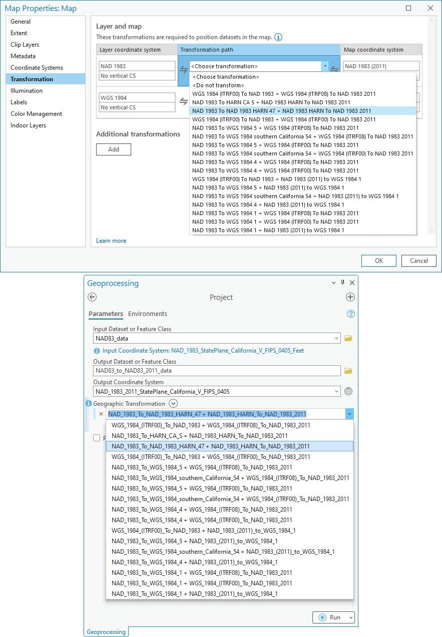
For example, let’s use California data in the original NAD83 (1986) datum. California falls under transformations valid for the contiguous United States. To transform the data to the latest NAD83 (2011) datum, it requires four transformations to be applied to the data (see the list above). The transformation drop-down list returns two-step transformation paths, where most paths in the list transform through the unsuitable WGS 1984 datum (see the image above).
You may be able to use the second or third transformation path, which transforms the data through the NAD83 (HARN) in-between datum, but only for display purposes, and not for high-accuracy work. The NAD_1983_HARN_To_NAD_1983_2011 (WKID::108355) transformation used in these paths assumes that the NAD83 (HARN) and NAD83 (2011) datums are equivalent, but they differ by a few centimeters.
To convert this data, you need to manually convert the data with the Project tool by either:
- Running the tool multiple times with two-step transformation paths through appropriate in-between NAD83 datums (Workflow 1, blue), or
- Building the direct and correct transformation path manually in the Geographic Transformation parameter of the tool (Workflow 2, green).
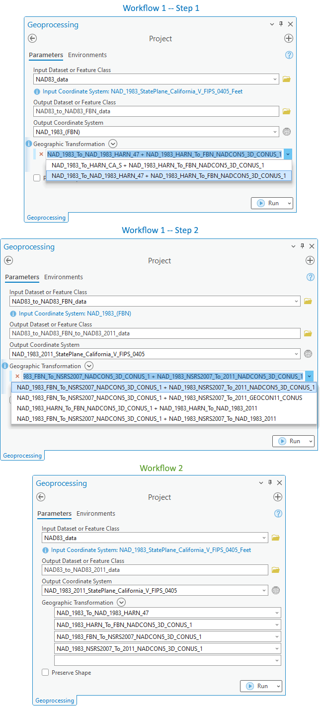
Both workflows described above produce the same results. You should use the one that is most straightforward for you. In the first workflow (blue), NAD83 (FBN) is used as the bridging datum between the first and the second step. NAD83 (HARN) is the in-between datum in the first step when the data is transformed from the original NAD83 (1986) to NAD83 (FBN). In the second step, the target NAD83 (2011) datum is reached through the NAD83 (NSRS2007) in-between datum.
For the second workflow (green), you need to manually type the exact transformation names in the correct order to successfully run the Project tool. All transformation names are published online in the list of supported transformations for ArcGIS Pro. Each supported transformation is bidirectional and can be applied in either the forward or inverse direction.
Convert orthometric heights and other 3D data
When working with orthometric or ellipsoidal heights, transforming data to the latest horizontal (geometric) and vertical datums is slightly more complicated. With NADCON 5.0 transformations, it is only possible to transform ellipsoidal heights together with corresponding horizontal positions between NAD83 (HARN), NAD83 (FBN), NAD83 (NSRS2007), and NAD83 (2011/PA11/MA11) datums. The original NAD83 (1986) and NAD27 are considered 2D geodetic reference systems and NADCON 5.0 can only transform longitude and latitude coordinates.
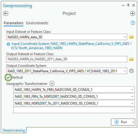
Converting ellipsoidal heights to NAD83 (2011/PA11/MA11) datums can be accomplished in ArcGIS Pro with the same two workflows presented above. The input dataset and output coordinate systems must be tagged with the appropriate vertical coordinate systems, and the Vertical option must be checked for the Project tool to also convert ellipsoidal heights.
When converting ellipsoidal heights to corresponding orthometric heights, the NGS recommends the use of the GEOID18 model for the contiguous United States, Puerto Rico, and the U.S. Virgin Islands, which supersedes the GEOID12B model in these regions. For Alaska, Hawaii, Guam, and the Commonwealth of the Northern Mariana Islands, the GEOID12B model remains the most current model. Both geoid models are intended for use with coordinates in the latest horizontal datums, NAD83 (2011), NAD83 (PA11), or NAD83 (MA11). They provide orthometric heights in the NAVD88 vertical datum for the contiguous United States and Alaska, and to the respective vertical datums (GUVD04, NMVD03, PRVD02, VIVD09, ASVD02) for other regions. Both geoid models are available in ArcGIS Pro, and the corresponding vertical transformations are activated when the ArcGIS Coordinate Systems Data is installed.
In preparation for the upcoming new vertical geopotential datum, the NGS released VERTCON 3.0 transformation grids within the NCAT tool. These grids allow conversion from the NGVD29 to NAVD88 vertical datums for the contiguous United States and Alaska, from the GUVD63 to GUVD04 vertical datums for Guam, and from local tidal datums to the corresponding current vertical datums for the Commonwealth of the Northern Mariana Islands (NMVD03), Puerto Rico (PRVD02), the U.S. Virgin Islands (VIVD09), and American Samoa (ASVD02). It is worth mentioning that there is no official vertical datum in Hawaii and therefore VERTCON 3.0 does not provide a transformation grid for the state. Previous versions of VERTCON transformations only allowed conversions between the NGVD29 and NAVD88 datums for the contiguous United States.
The latest ArcGIS Pro release (since ArcGIS Pro 3.3) supports the VERTCON 3.0 transformation files. According to the EPSG (and this article published in Professional Surveyor magazine):
“Most horizontal positions of the benchmarks used to generate the VERTCON grids were scaled from USGS topographic maps. The estimated uncertainty of the scaled positions, 6 arc-seconds, is greater than the differences between NAD27 and NAD83 coordinates. Therefore, the latitude and longitude used for interpolation of the grids can be referenced to either NAD27 or to NAD83 (1986) or to any of the NAD83(NSRS) realizations (HARN, NSRS2007 or 2011).”
Therefore, ArcGIS Pro includes vertical transformations using the same VERTCON 3.0 grids on the known historic and current horizontal datums valid for the contiguous United States, Alaska, and Guam:
For Contiguous United States (CONUS)
NGVD29_To_NAVD88_NAD27_CONUS_VERTCON3 (WKID::110201)
NGVD29_To_NAVD88_NAD83_CONUS_VERTCON3 (WKID::110202)
NGVD29_To_NAVD88_NAD83_HARN_CONUS_VERTCON3 (WKID::110203)
NGVD29_To_NAVD88_NAD83_CORS96_CONUS_VERTCON3 (WKID::110204)
NGVD29_To_NAVD88_NAD83_FBN_CONUS_VERTCON3 (WKID::110205)
NGVD29_To_NAVD88_NAD83_NSRS2007_CONUS_VERTCON3 (WKID::110206)
NGVD29_To_NAVD88_NAD83_2011_CONUS_VERTCON3 (WKID::110207)
For Alaska
NGVD29_To_NAVD88_NAD27_Alaska_VERTCON3 (WKID::110208)
NGVD29_To_NAVD88_NAD83_Alaska_VERTCON3 (WKID::110209)
NGVD29_To_NAVD88_NAD83_HARN_Alaska_VERTCON3 (WKID::110210)
NGVD29_To_NAVD88_NAD83_NSRS2007_Alaska_VERTCON3 (WKID::110211)
NGVD29_To_NAVD88_NAD83_2011_Alaska_VERTCON3 (WKID::110212)
For Guam
GUVD63_To_GUVD04_NAD83_HARN_VERTCON3 (WKID::110213)
GUVD63_To_GUVD04_NAD83_FBN_VERTCON3 (WKID::110214)
GUVD63_To_GUVD04_NAD83_MARP00_VERTCON3 (WKID::110215)
GUVD63_To_GUVD04_NAD83_MA11_VERTCON3 (WKID::110216)
Despite there are transformations for each horizontal datum, our recommendation is that height conversion from the NGVD29 to NAVD88 vertical datums is performed based on positions in the original NAD83 (1986) horizontal datum for the contiguous United States and Alaska. For example, let’s use a California 3D dataset defined in the historic NAD27 horizontal datum with heights in the historic NGVD29 vertical datum. To convert the data to the current NAD83 (2011) and NAVD88 datums, the workflow requires three individual runs of the Project tool (see image below):
- Convert horizontal positions from NAD27 to the original NAD83 (1986) datum,
- Convert heights (Vertical option is checked) from the NGVD29 to the current NAVD88 vertical datum using VERTCON 3.0 grids and horizontal positions defined in the NAD83 (1986) datum, and
- Convert only NAD83 (1986) horizontal positions to the current NAD83 (2011) datum through appropriate in-between NAD83 datums. This step is basically the second workflow presented above. It can be replaced by the two-step workflow to convert NAD83 (1986) data to the NAD83 (2011) datum.

In the workflow above, the first and third steps can be combined and the vertical transformation between the NGVD29 and NAVD88 datums (the second step) can be performed prior to (with NAD27 coordinates) or after the positions are converted to the current NAD83 (2011) horizontal datum. All vertical transformations using VERTCON 3.0 grids are activated in ArcGIS Pro with the installed ArcGIS Coordinate Systems Data.
Additional recommendations
Working with datasets in multiple coordinate systems and historic datums is not a straightforward task. Familiarize yourself with all current valid and historic datums for the U.S. and learn the history about them, especially if you are maintaining such datasets. Knowing their history can help you understand why certain data does not align well with other datasets and help you troubleshoot any issues you may encounter.
You should also familiarize yourself with the quality of your data and how the data was originally obtained. Was the data originally collected in some historic U.S. datum and later converted? What transformations were used in the process? Knowing the accuracy of your data and any additional information, such as the epoch of your dataset, may help you identify which NAD83 datum your data is referenced to, whether the datum is correctly assigned to the dataset, and what discrepancies may be acceptable and expected.
When converting data in historic coordinate systems to the latest NSRS datums and realization, it is recommended that you document this procedure in detail, including which transformations were used and what assumptions were made in the process. Such information is essential for a comprehensive understanding of how the data was obtained and processed. This also helps you to determine the accuracy of the data and what discrepancies and misalignments can be expected. Knowing the procedure is also crucial for data maintainers in case they need to revert the conversion to the initial datums and repeat the process with more current and accurate transformations if they become available in the future.
Many datasets today are published and shared online. Often, these are shared in the default WGS 1984 Web Mercator (WKID::3857) projected coordinate system. Converting data to coordinate systems based on the WGS 1984 datum ensemble diminishes data quality, as the WGS 1984 datum ensemble accuracy is about 2 meters. When publishing data, especially authoritative data, always share it in the official, authoritative coordinate system, such as the State Plane coordinate systems defined on the current datums: NAD83 (2011), NAD83 (PA11), or NAD83 (MA11).
Special sessions at Esri conferences
To assist you with this transition and help you prepare for the modernized NSRS 2022, we are organizing special sessions at the 2025 Esri conferences. If you are attending any of the conferences listed below, you may find these sessions valuable.
- National Spatial Reference System Updates (link to agenda)
Professional Development Session at the 2025 Esri Federal GIS Conference
- ArcGIS Pro: Preparing Your Data for the Future NSRS 2022 Shift (link to agenda)
Demo Theater Presentation at the 2025 Esri User Conference
Additional resources
Everything about NSRS 2022 and new datums for the U.S.
All issues of NSRS Modernization News
NSRS Modernization Alpha Product Release Site
All information about Alpha SPCS2022
Current horizontal and geometric datums in the U.S.
Current vertical datums in the U.S.
Geoid models for the U.S.
NGS Coordinate Conversion and Transformation Tool (NCAT)
NADCON 5.0 transformation grids
VERTCON 3.0 transformation grids
ArcGIS Coordinate Systems Data software component
List of all supported transformations in ArcGIS Pro
Project (Data Management) tool
Project Raster (Data Management) tool
List of useful resources for ArcGIS users
This blog post was originally published on October 17th, 2023, and has been updated.


Commenting is not enabled for this article.