Released in November 2020, ArcGIS Field Maps is a powerful mobile app solution that streamlines mobile workflows within a single, location-aware mobile app.
We’re hard at work on the February 2023 release of ArcGIS Field Maps. It’s tentatively scheduled for release on February 22nd and we have lots of exciting new features coming. Today we’re pleased to announce the opening of our 2023 Early Access program! It includes a handful of new features that you can start testing ahead of our release in February.
What’s Coming
The February 2023 update is focused on improving existing offline workflows, form authoring and editing capabilities, and introducing new settings for location sharing.
Offline improvements
When preparing maps for offline use, map authors can choose to use the basemap defined by the web map or a tile package as the offline basemap. Using a tile package allows you to provision devices with larger and more detailed basemaps and use them across multiple maps.
With this update, map authors can now browse and select a tile package that is shared as an item within their organization. Once referenced, downloading a map area will download the referenced tile package if it is not already present on the device or just use it if its already there.
Map Author experience
Using the Create Map Tile Package Tool or Create Vector Tile Package Tool within ArcGIS Pro, you can create a new tile package and upload it to your organization using the Share Package tool. If you have an existing tpk or vtpk, you can simply add a new item from file directly.
Then, opening the Field Maps Early Access web app, click the Offline page and expand the “Basemap and tile package” section to locate the new option to browse and select an existing tile package within your organization.

Mobile worker experience
Using Field Maps on your iOS or Android device, the referenced tile package will immediately download to your device if it does not already exist. Once present on the device, it can be re-used with multiple maps and map areas.
Organizations with a distributed workforce, that may operate in a corridor, that perhaps cannot connect devices to manually provision tile packages, will benefit from this enhancement the most.
This new capability is available for testing right now in the Early Access program.
Form improvements
Field Maps introduced new smart form capabilities into the ArcGIS system that improve the way mobile workers and web editors capture non-spatial data into map layers and tables. Until now, all of the form logic has been stored with the map.
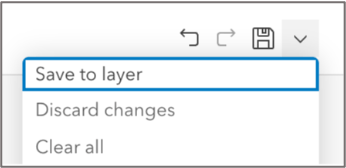
With the February update, you’ll have more flexibility. When configuring the form, you can continue to store form information as part of the map or you can save form information directly to the layer item itself. Saving form details to a layer item means that every map that layer is used in can provide the same form experience.

The Map Viewer supports saving form information to a layer as well. So you can use the Map Viewer and/or the Field Maps web app and choose how you want to persist forms.
This new capability is available for testing right now in the Early Access program.
Location Sharing improvements
ArcGIS Field Maps includes the ability to record and share your location and location history within your organization. This capability works in the background, when disconnected, and can be used independent of a map to improve operational awareness for a variety of different workflows.
With the February update, we are adding 2 new configuration settings:
1. Use App Links to configure the upload frequency of last known locations for non-managed devices. Organizations that need to support multi-agency response efforts, contractors, or simply do not utilize an MDM for application deployment can take advantage of this new app link setting. Generating a QR code using the app link scheme, mobile workers can use their camera to quickly configure the upload frequency from the default of 60 seconds to as frequent as 5 seconds.
2. Provide real-time operational awareness without recording or storing location history. Configurable via an app link and as an MDM configuration keyword, organizations can use location sharing to only store and record last known locations and not persist location history. Generating a QR code using the app link scheme, mobile workers can use their camera to quickly configure Field Maps to only record and share their last known location and not their location history.
These new capabilities is available for testing right now in the Early Access program.
But there’s more…
We have additional capabilities coming in February that did NOT make their way into the early access program.
Arcade Expression enhancements
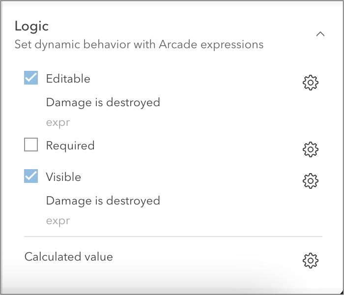
Arcade expressions power the form capabilities in ArcGIS Field Maps. They’re used for calculating form values, for conditional visibility, and now they can be used to determine whether information within the form is required or can be edited.

When writing arcade expressions we’re upgrading to the new Arcade editor that was added into the November release of ArcGIS Online. With the new Arcade editor, you have much more space to write your expressions, you can take advantage of profile variables, grouping of functions, and Intellisense!
Smart card reader support
The iOS 16 release includes support for connected smart card readers. That means organizations using PKI authentication with PIV smart cards and CCID-compliant readers can now authenticate into their ArcGIS Enterprise portal and use Field Maps.
What’s Next
We’re excited to kick off 2023 with many new capabilities coming in February. Through the year we’ll have 2 major releases coming in June and November. Look for more updates on what will be included in those releases later this year!
Article Discussion: