So ya, this is a post about using CASE tools at ArcGIS 10 (CASE tools are a separate set up that you can access from your media disc or download from the customer care site). But before I get into that let me just say that, while CASE tools are still supported at ArcGIS 10, I personally think that a better place to start building a geodatabase schema, or a GIS in general, is to begin with one (or a combination) of the following:
- Look at some predefined maps, such as those created by the Local Government team on ArcGIS.com. Load these into ArcGIS, study how they are built, read the associated documentation, see how you can use your data with these maps and applications, then try building your own.
- Download a template from the resource centers to pour your data into, such as those found on the Electric and Gas or Defense and Intelligence sites.
- Download one of the industry-specific Data Models from the resource center and adapt your data to it or adapt it to your data.
Ok, that’s my spiel. But yes, another method for building your geodatabase schema is to use CASE tools.
What are CASE Tools anyways?

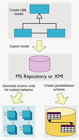
The computer-aided software engineering (CASE) tools subsystem lets you create blueprints of the structure of the geodatabase using a graphical language—the Unified Modeling Language (UML). Using class diagrams, you can represent geodatabase elements, such as feature datasets, feature classes, and tables.
So basically, you can use Microsoft Visio to construct your UML model, export that to an XML Metadata Interchange (XMI) file and then use CASE tools to import the XMI into ArcCatalog and generate the schema of your geodatabase.
To learn more about designing geodatabases with CASE tools you should check out the site Building geodatabases with CASE tools. You can download documentation and tutorials there to wrap your brain around the idea and help get started.
(But be sure to also read A note about the use of UML for geodatabase design, which offers some additional ammo to my above spiel).
Ya champ, I know all that already, but I’ve been using UMLs to generate geodatabase schema for years and what I really want to know is why my UMLs aren’t working with ArcGIS 10?
Oh, well UML Models created with a Visio 2003 template have a conflict with the ArcGIS 10 dll files that Visio references. Soooooo, some limitations are encountered when using the Semantic Checker in Visio 2003.
If you’re having a problem with your UMLs in ArcGIS 10 you should take a look at this KB article which steps through a procedure to get things working. If you don’t have the appropriate key set in the system registry, as described in the last step of the article, you can download a reg file from the geodatabase gallery that will add it.
Alright, enough about these CASE tools. What I really, really wanna know is… are you gonna go my way?
No Lenny, I am not.

Commenting is not enabled for this article.