Probably the most visible and intriguing aspect of the new data compilation (editing) tools with ArcGIS 10, are feature templates. Feature templates are how you add features to your database and therefore will be used in one form or another by everyone that edits their data. Templates are used to define the types of objects that you create on a map and are comprised of the following items:
- Name
- Description
- Target layer (layer and ultimately the feature class the object will be created in)
- Symbol used to draw the feature
- Default attribute values
- Default tool used to create the object
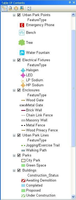
When you begin editing your data in ArcMap with ArcGIS 10 for the first time, feature templates will automatically be created for you based on how your data is symbolized. If I have symbology in my map that looks like this:
Will be turned into a set of feature templates that look like this when you begin editing.
Template creation works best when your symbology is based on unique values for the layer, but that is not required. Once templates are initially created, you have the ability to add, remove, and update them as you see fit for your requirements. The properties of a template can be updated by double-clicking on the template you want to change or by right-clicking and selecting “Properties…” from the context menu. When the Properties dialog is display, you have the ability to change the name, add a description, set a default tool to use, and to set default attribute values (values that will automatically be applied when a new feature of this type is added). The ability to change these properties as well as to add and remove templates gives you much more control on authoring the editing experience for yourself and your end users then you’ve had before. Feature types that don’t need to be added for whatever reason can be removed from the palette to reduce clutter. In addition, the template list is automatically adjusted when you change scale or turn layers on and off, so things that you can’t see on the map (because of scale dependency or because the layer isn’t visible) do not show up in the list.
Many people will use feature templates within their own editing workflows, but we also anticipate an increase in the authoring of maps for editing were someone will define the templates and then save them in a map document, layer file or layer package for use by others in the organization or outside the organization. The authoring of maps and layers for editing takes on new meaning with the addition of feature templates at ArcGIS 10, as well as other features such as the ability to define field properties (read-only, highlight, etc.) that will be discussed in other blogs.
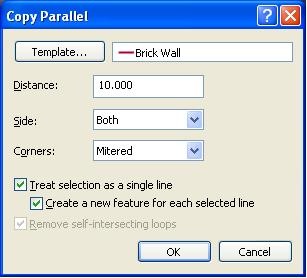
Once feature templates have been defined, they are immediately available for use from the Create Feature palette shown above. To add a new feature the user need only pick what they want from the palette and begin sketching. No need to set target layers, edit task, etc. as done with the editor at 9.x and before. Feature templates are also used in the other commands with the editing environment where new features are created. For instance, after adding or selecting a line feature I can choose the Copy Parallel command from the Editor dropdown and see the following:
By default the last template used is displayed in the box next to the Template button. If a different template is needed you need only click on the Template button to display the palette of available feature templates to choose from. All options within the editor that create new features allow you to choose a feature template to use.
Since feature templates can be stored as part of a map, layer file, map package or layer package, they are easy to share and make use of in other environments. Map and layer packages can be shared through ArcGIS Online or other methods so that others can quickly make use of the authored templates. In addition, templates stored in a map document are available with Feature services through ArcGIS server so users of web applications can have the same user experience of choosing a defined feature template from a palette for the easy addition of features on the map.
Please see the help for ArcGIS 10 for more information on creating and using feature templates.
Content provided by Larry Young


Commenting is not enabled for this article.