Growing throughout most of the eastern United States, white oak (Quercus alba) is a hardwood species that has long been used as the major source of wood for bourbon barrels, in part because it is resistant to rot and decay and offers the strength and durability needed to age whiskey. White oak barrels are also used for aging American whiskey, rum, tequila, sherry and wine.
Bourbon is recognized as “a distinctive product of the United States” and distilleries are legally required to age bourbon in new charred oak containers, which means barrels can only be used once for bourbon. Charring new oak barrels, or subjecting them to intense heat, results in a chemical reaction in the barrel’s interior and over time, allows the bourbon to extract distinct flavors, such as vanilla, toffee and caramel.
There are over 10 million barrels of bourbon aging in distillery warehouses in Kentucky alone, and with growing market demand, the spirits industry is facing continuous market pressure to increase bourbon production. Since distilleries are legally required to age bourbon in oak containers, cooperages (wooden barrel manufacturers) are always looking to find new sources of white oak. In addition to identifying where white oak grows, resource managers and procurement foresters need to know the tree size, proximity to urban areas and manufacturing facilities, the impact white oak has on drinking water, and forest ownership. These multiple factors are all used to help determine accessibility, viability, and resource sustainability.
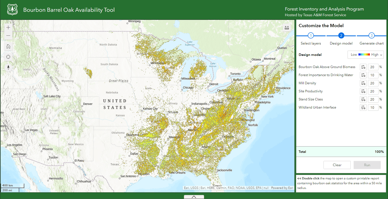
The USDA Forest Service’s new Bourbon Barrel Oak Availability Tool was developed in consideration of the need to balance the demand for white oak barrels and to safeguard the sustainability of the white oak species. It is an easy-to-use web app for identifying white oak resources and analyzing multiple criteria so results can be incorporated into sustainable planning and procurement initiatives. The app leverages scientifically credible forest resource data from the Forest Service’s Forest Inventory Analysis (FIA) program. Their cloud-based Big Data Mapping and Analytics Platform (BIGMAP) allows the Forest Service to process and share vast collections of authoritative content at scale for Forest Service agency leadership and a diverse stakeholder community.
“The more spatially explicit the data the better the planning is going to be. This app can provide fine scale, spatially explicit information that allows managers to plan for the long-term.” Chris Oswalt, USDA Forest Service.
Answering the Question of “Where”
The Bourbon Barrel Oak Availability Tool was configured using ArcGIS Experience Builder, which is Esri’s latest technology for building compelling web apps. Instead of requiring web app developers to write their own code, ArcGIS Experience Builder gives users the ability to configure powerful web apps with drag-and-drop operations by providing a library of predefined tools and widgets. The flexibility of this framework lends to powerful analysis and visualization functionalities supporting users with their decision-making needs on desktop, tablet, and mobile devices.
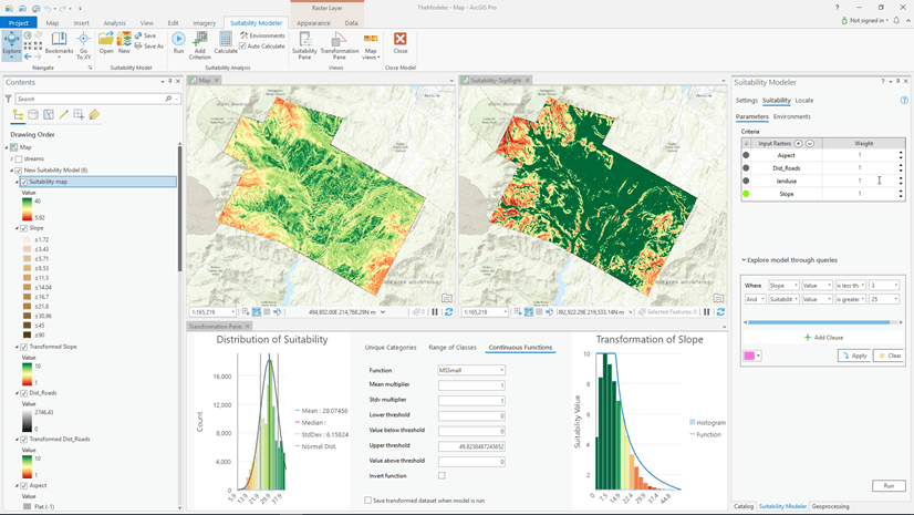
The main widget used in the Bourbon Barrel Oak Availability Tool is the newly released Suitability Modeler widget that allows users to combine different layers so multiple factors can be evaluated at once. The suitability Modeler widget is a tool that provides an interactive, exploratory environment for creating and evaluating a suitability model. In suitability modeling analysis, data is classified and combined and the model locations relative to each other based on given criteria to identify sites most suitable for a specific use. The suitability modeler widget uses a hosted weighted overlay service. Hosted weighted overlay services are built from mosaic datasets that are shared as image services.
Suitability models help to answer the question of “where?” Such as, where is the optimal location for establishing a mill site based on distance from other sites, forest type, stand age, species occurrence, and land use type.
The WRO used within the Bourbon Barrel Oak Availability Tool is preconfigured to identify and locate white oak resources. The WRO was compiled with seven criteria layers relevant to white oak resourcing, enabling white oak procurement foresters, land managers, landowners and resource managers to make better and more informed planning and procurement decisions.
- Bourbon Oak Species Above Ground Biomass—Displays the locations of select white oak species
- Mill Density—Used to determine the overall pressure on white oak based on the number of mills within a region
- Site Productivity—The potential for how productive a white oak stand might be in terms of cubic ft of growth per year
- Stand Class Size—Represents to relative size for a stand of white oak
- Wildland Urban Interface—The relative distance of a stand from urban areas or within the rural urban interface.
- Forest Importance to Drinking Water—USDA Forest Service watershed index of surface drinking water importance
- Forest Ownership—Private or public ownership
User interface/Experience
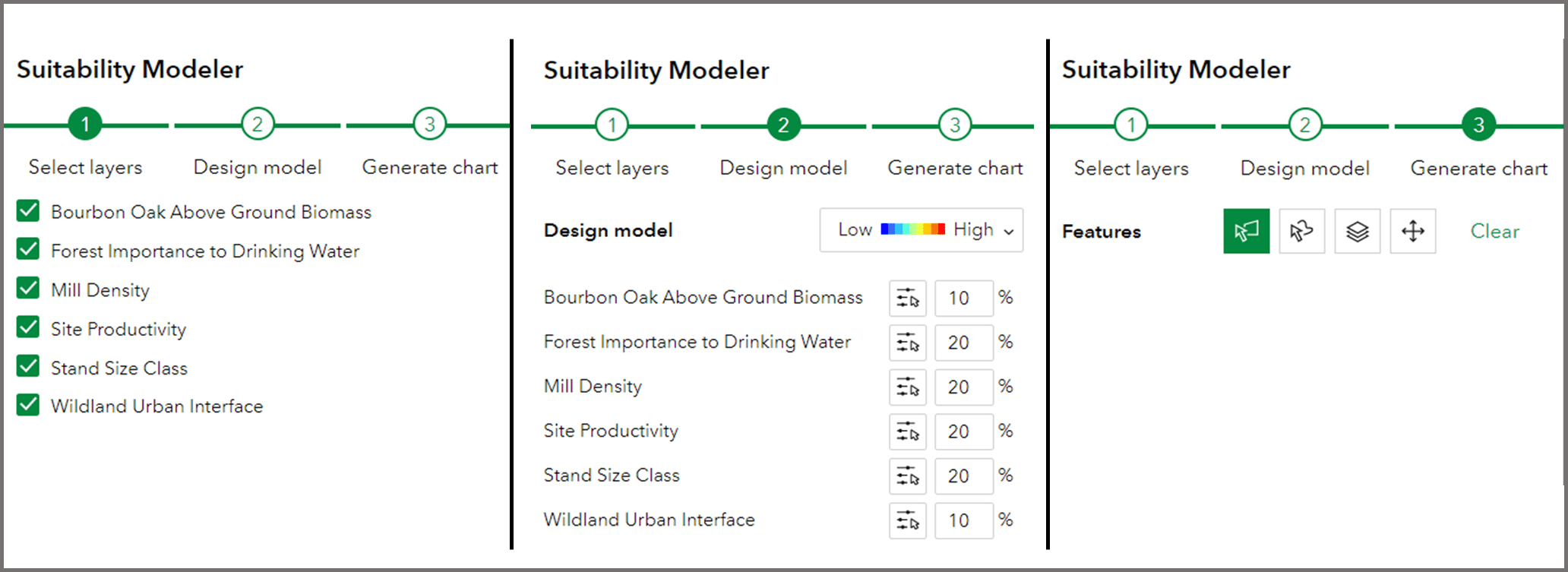
By design, the user interface offers a simplified user experience with widgets available for navigating around the map and analyzing the pre-loaded weighted raster overlay data. On the left-hand side of the app, widgets are available for zooming into the map, zooming out of the map, going to the default map view, finding a specific location, and resetting the map orientation. On the right-hand side users will find the suitability modeler. The modeler offers a three-step workflow plus a bonus step allowing users to:
- Select the suitability criteria to model
- Design the model, including determining the color ramp and designating score values
- Generating the suitability chart for a defined area of interest
- View an in depth statistics report by double clicking an area of interest on the map
To conduct the analysis, complete each step consecutively.

Step 1: Select Layers
Specify which layers to include in the modeling output by selecting from layers in the configured WRO service. Once the suitability criteria layers have been selected, move to step 2 to design the model.
Step 2: Design Model
Assign each selected layer a relative importance in the analysis by specifying the individual weights in the percentage (%) text box. All weights must add to 100 percent. Assign suitability scores (0 to 9) to the ranges for each of the selected layers. Optionally, change the color ramp for the results. This panel includes the following buttons:
- Clear—Clear all the parameters in the widget, including the selected layers, scores, weights, results, and charts.
- Export (optional)—Save the model as a weighted overlay model service that can be added to maps or used as the starting state for a preconfigured model. Currently, to see the Export button when they open the app, the user must be signed in with an ArcGIS account that has privileges to create content in their organization.
- Run—Add the suitability model layer to the connected Map widget based on the selected layers, weights, scores, and colors in the model. Running the model again with changes updates the layer in the map.
Step 3: Generate Chart
Draw a polygon, freehand polygon, or select a layer to use as the geographic extent for the calculating the model’s output. The Pan tool moves the map without changing the polygons. (Users can click “Clear” to clear the drawn or selected polygon.)

For users who have defined an area and would like to evaluate topographic variations within their area of interest, the app also includes an elevation profiler. By clicking the up arrow at the bottom of the app you can draw a line directly on the map to get an elevation profile. Additionally, you may also select the measure tool on the right-hand side of the application if you need to calculate the distance between two locations.
Learn from the 40-year experience of a procurement forester who has exclusively sourced white oak for both the veneer and bourbon industries.


Article Discussion: