With the release of ArcGIS AppStudio version 5.1, we have improved our templates by adding exciting new features, enhancements, and bug fixes to help you create cross-platform native apps easier and faster. In this release we have added two brand new templates, introduced a new spatial query tool to the Map Viewer template, and updated all templates to fully support ArcGIS Runtime 100.11 and Qt framework 5.15.2.
Visit the What’s New post to learn about all the updates in AppStudio 5.1.
New templates
Nearby
The Nearby template provides a native app experience to discover nearby map points, and includes filters to narrow your search by distance or feature category. Some use cases for this template include looking for restaurants, hotels, finding public community resources (parks, pools senior centers), discovering COVID-19 testing sites, or locating the closest field asset for inspection.
The configuration experience for this template follows the same pattern as the AppStudio Attachment Viewer app template. First, start by creating a Nearby Instant App web application and then provide the unique web application ID within the template settings in AppStudio desktop. You can choose to configure more than one app ID or a group ID consisting of multiple Nearby web applications. You can then optionally add your own branding – icons, colors, and splash screen images – to make the Nearby native app your own. For more information on configuring this app, see the Nearby template documentation.
AppStudio’s Nearby template app works similar to the Nearby web application. Currently, AppStudio supports the following properties as configured in the Nearby web application:
- Filters
- Distance slider
- Show directions
- Show distance values
- Group results by layer
- Basemap toggle
- Welcome and no result configured messages
Please feel free to provide feedback with use cases if you’re looking for us to add support for more properties in the future.
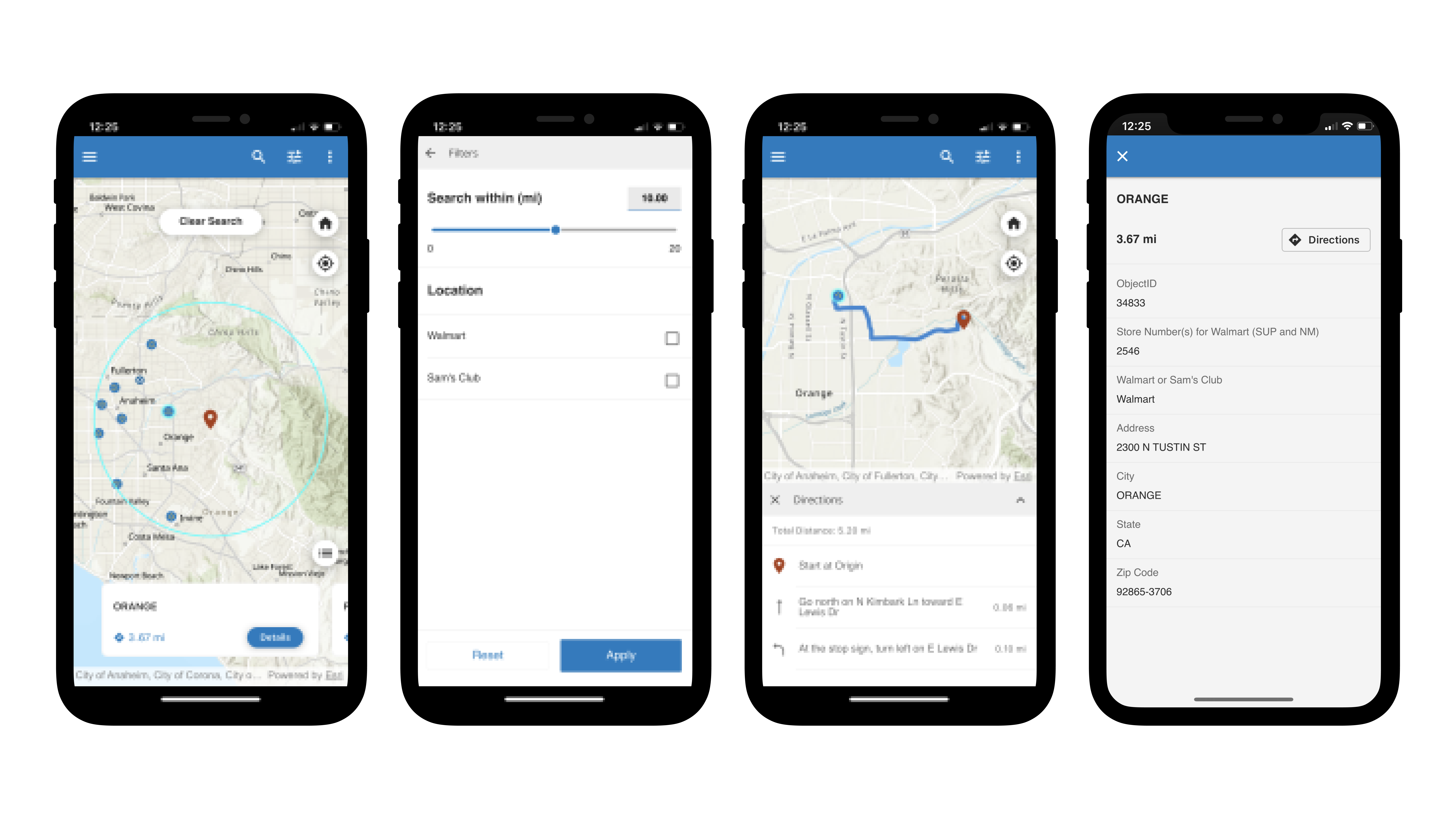
Here is a working example of the Nearby native application created from the AppStudio template while consuming an ArcGIS Nearby web application.
Zone Lookup
Like the Nearby template, Zone lookup also provides a native mobile app experience which will help community members answer questions about their location in relation to a zone. In this app the zones are polygon feature layers (areas), and the app will report back which zone you are in based on your current GPS location or by interactively selecting a location on the maps. Some Zone Lookup app use cases include finding your child’s school district or your electoral precinct, checking if your house is located in a flood zone, determining a utility service area, or searching for current wildfire evacuations.
The configuration is similar to that of the Nearby app, start by creating a Zone Lookup web application and then add your own branding – icons, colors, and splash screen images – to make the Zone Lookup native app your own. For more information on configuring this app, see the Zone lookup template documentation.
AppStudio’s Zone Lookup template app works like the web application. Currently, AppStudio supports the following properties as configured in the web application.
- Group results by layer
- Basemap toggle
- Welcome and no result configured messages
- Show bookmarks
Please feel free to provide feedback with use cases if you are looking for us to add support for more properties in future.
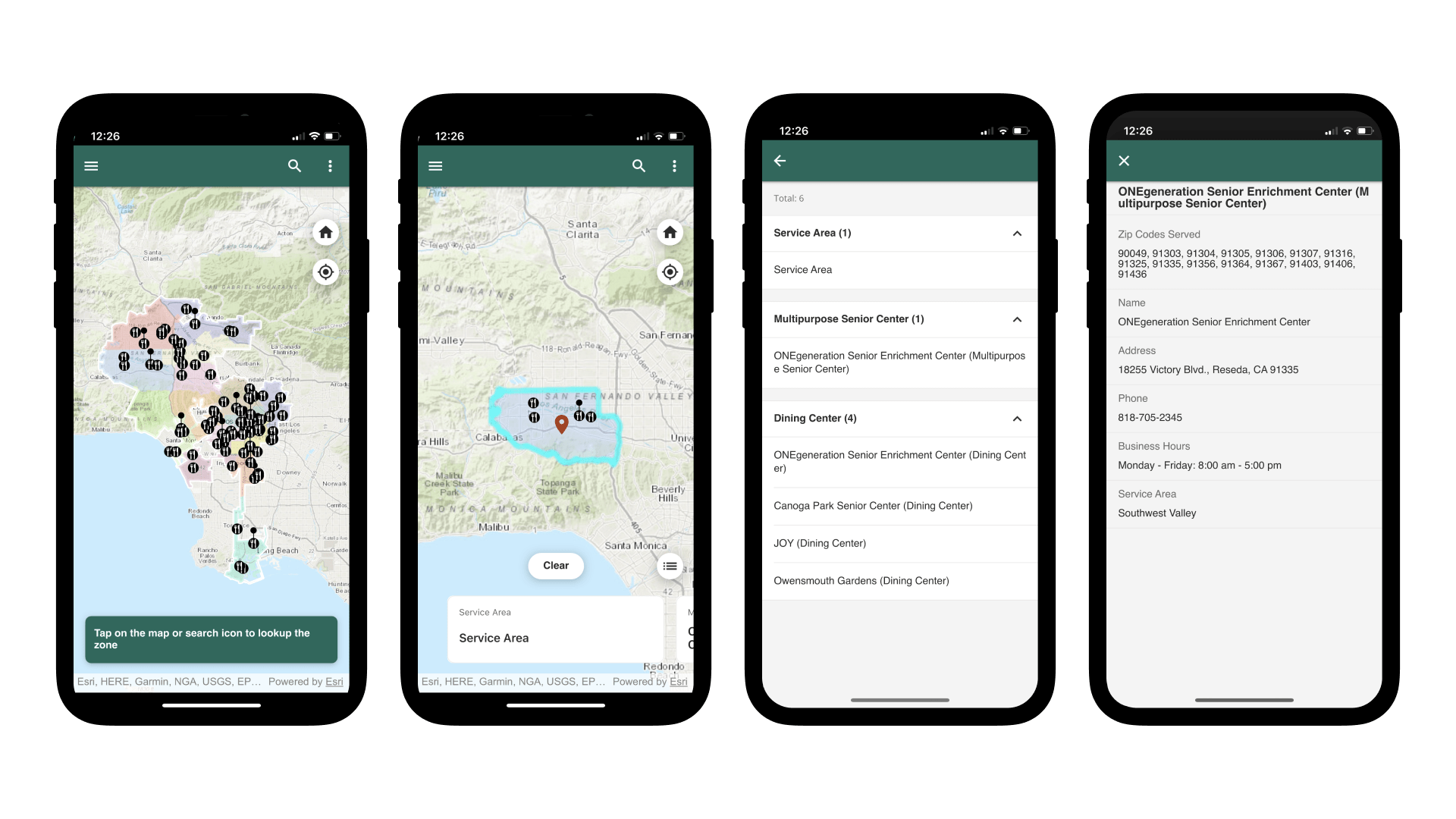
Here is a working example of the Zone Lookup native application created from the AppStudio template while consuming an ArcGIS Zone Lookup web application.
Map Viewer Update
New Spatial Query Tool
The spatial query tool is a new addition to the Map Viewer template. This allows the user to perform a query (selection) on the available feature layers within the web map based on the distance specified from a desired location or using the current extent of the map. You can select the initial location by tapping on a map pin graphic then proceed to create a buffer polygon based on the specified distance and units. The using the polygon a query is performed on the visible feature layers which intersects with the buffered polygon. Only results returned from the query will appear on the map or within the list. You can further identify the results and view the detailed popup by tapping on the feature in the map or choosing items from the results list. Users can feel free to alter filters such as adding or removing layers to be shown in the result or adjusting the chosen distance. When using the current map extent for a query, the results are based on all the features currently visible on the map and the selected layer filters.
Layer types such as Feature Collection layers which are not the part the filter list will continue to show the features before or after the spatial query. If you don’t want these features to appear on the map while discovering the spatial query results, you can hide such layers from the layer content list which can be accessed using the info tool from the toolbar.
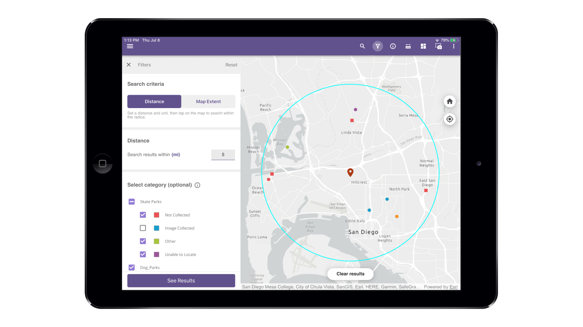
Here is a working example showing query results for filtered layers based on a buffer distance of 5 miles from the map pin location.
Other improvements within Map Viewer
- Updated the codebase for Map Viewer to fetch the OID field using Runtime API instead of hard coded ObjectID field name when used for purposes such as MMPK feature searches based on attributes, identifying Related records, and displaying popups
- Updated the downloaded map areas to load directly as MMPKs instead of manually constructing operational layers before adding to the map
- Fixed the media image link for feature attachments within Map Viewer
Try it yourself!
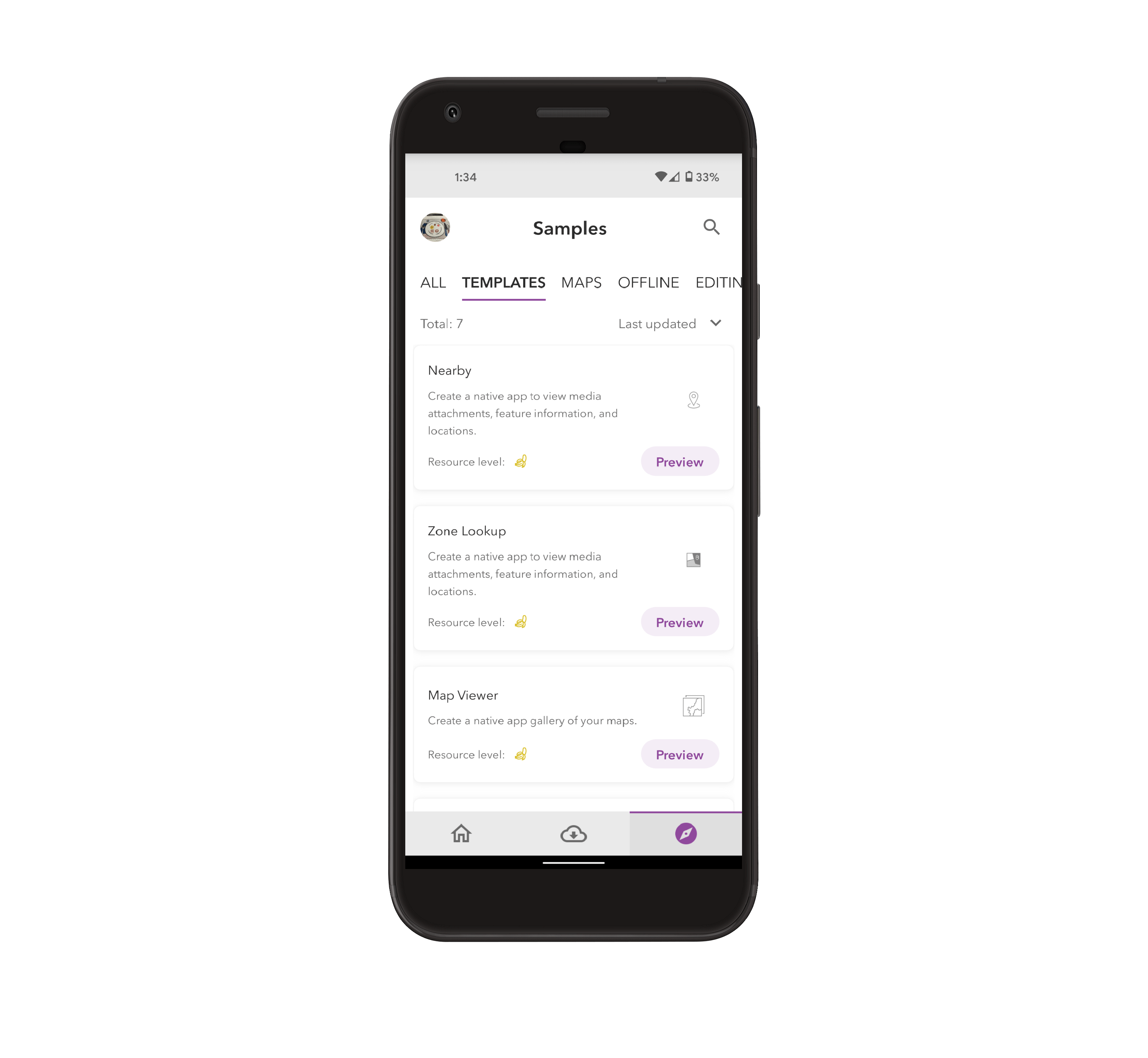
Would you like to try these new features on your mobile device? You can easily run the Nearby template, Zone Lookup template, and Map Viewer spatial query tool using AppStudio Player. Here are few steps involved in this process
- Download & install the AppStudio Player on your mobile device from the App App Store or Google Play Store
- Run the Player app
- Go to the App Settings from the side menu
- Turn on “Developer mode” and then go back to the main page of the app
- Navigate to the third bottom tab to access samples and templates as shown below
General Improvements and bug fixes across various templates
- BUG-000140588 Setting the ‘Portal sort field’ property on a Map Viewer Template (5.0) app has no impact on the order of the Webmaps listed in the app gallery
- BUG-000140254 Layer names in Content and Legend are not equivalent as defined in Web Map when viewing an Offline Map Area in ArcGIS AppStudio Player.
- BUG-000140450 The order of the layers in the offline map areas in ArcGIS AppStudio is reversed compared to in the web map.
- BUG-000139666 Downloading an offline map with ArcGIS AppStudio MapViewer does not include the vector basemap.
For more information about specific bug fixes and additional details about this release, please see the what’s new in AppStudio online documentation and this ArcGIS Blog post.
We hope you like the new features and enhancements added to this release. Please provide any feedback and suggestion to appstudiofeedback@esri.com or leave your comment on GeoNet.
Become an AppStudio for ArcGIS developer! Watch this video on how to sign up for a free trial.
Follow us on Twitter @AppStudioArcGIS to keep up-to-date on the latest information and let us know about your creations built using AppStudio to be featured in the AppStudio Showcase.
The AppStudio team periodically hosts workshops and webinars; please click on this link to leave your email if you are interested in information regarding AppStudio events.

Article Discussion: