Born out of the Gov 2.0 movement, the terms transparency and accountability have become part of the daily vernacular of governments and the citizens they serve. One might even suggest these words have become a new expectation of governing. Transparency and accountability began with a simple concept of openly communicating public policy to the taxpayer. Today, these concepts are thriving within a growing emphasis on developing an interactive dialog between governments and the people.
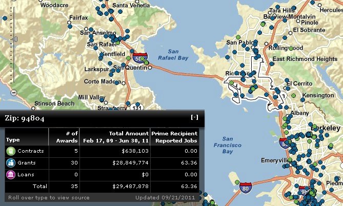
Maps can be a very valuable part of transparency in government. Maps give people a greater understanding of the world around them. They can help tell stories and many times be more valuable than the data itself. They provide a context for taxpayers to better understand how spending or decisions are being made in a circumstance of where they work and live. Maps help us describe conditions and situations, and help tell stories, often related to one’s own understanding of content.
Using maps helps citizens quickly visualize and understand what the government is doing in the areas that are important to them. The ability to take data, put it on a map, and serve it dynamically over the Web is very stimulating. These web intelligent maps are leading the way for citizens with limited or no GIS experience to interact and explore government information through dynamic mapping applications.
Taking transparency and accountability a step farther allows us to actively participate in shaping our communities. The strongest movement impacting our daily lives on a personal level is the rise of citizen engagement through social media and mobile devices. Today, citizen engagement apps enhance a variety of government-citizen interactions involving public information, requests for service, public reporting, citizen-as-a-sensor, unsolicited public comment, and even volunteerism. For example, Singapore’s One Map combines web and mobile apps for an enriched citizen experience.
In addition, Colorado and Oregon provide examples of how state-level governments are using spatially-enabled apps to achieve transparency and accountability. Maryland is expanding transparency and accountability by opening up participation in state planning efforts with SmartGrowthMD. And broadband mapping is a popular web app that allows the public to visualize broadband and comment on the planning of the nation’s infrastructure, as we have seen with BroadbandStat in South Carolina, Tennessee, Nevada, Ohio, Michigan, and Minnesota.
Geospatial technologies have already proven to be effective tools in responding to transparency, accountability, and citizen engagement demands. Intelligent web maps are acknowledged as a catalyst for solving key challenges in creating a dialog through informed citizens. As web and cloud-based GIS continue to evolve and social media and mobile devices become more pervasive, governments will continue to deliver innovative forums through interactive information and participatory citizens applications.
insider
