
October 29, 2024

Rising seas are slowly swallowing the Pacific island nation of Tuvalu—and the country’s leaders are taking action. They are using a digital twin to understand climate impacts and preserve their culture.
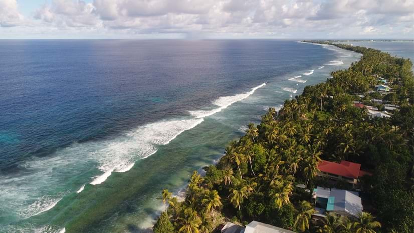
Nine islands make up Tuvalu, home to more than 10,000 people and situated halfway between Australia and Hawaii. The country—on the forefront of climate action—changed its constitution to declare it would always be a nation, even if its islands are no longer inhabitable.
“We are looking at setting up the world’s first digital nation because we are facing the real risk of our land disappearing,” said Tuvalu’s foreign minister Simon Kofe, standing knee-deep in water while addressing the United Nations Convention on Climate Change (COP26) in 2021.
Digital twins come to life with a combination of imagery and geographic information system (GIS) technology. With the digital twin, decision-makers can analyze details about a place, its people, and the environment. The 3D model serves as both a record and a platform to navigate incidents and changes. It also provides a means to experience the place within virtual reality headsets.
Kofe’s speech, and the country’s commitment to digitize itself in case it disappears, puts the world on alert about the vulnerability of island nations. Many others, including Grenada, have adopted similar reality-capture techniques to face a changing environment and record what makes them unique.
Tuvalu is experiencing many climate hardships, including areas perpetually underwater, saltwater intrusion into drinking water, and coral bleaching. Because the depth of the ocean drops off deeply around the islands, the shores aren’t susceptible to huge waves. But the islands have experienced cyclones, which erode shorelines and destroy homes. With the digital twin, Tuvalu can assess the dimensions of these ongoing challenges.
The first step is to collect location-specific data and regularly update it so changes can be measured. In September 2023, on the sides of the United Nations General Assembly meetings in New York, and with the support of the Secretariat of the Pacific Community (SPC) Digital Earth Pacific (DEP) program, the nonprofit PLACE signed an agreement with the Prime Minister of Tuvalu to collect detailed data for the total land area of 26 square kilometers.
“The Digital Earth Pacific program enables decision-making for the Pacific Peoples through the use of earth observations. PLACE data enhances the program by providing highly detailed and accurate images that support Pacific nations in addressing climate change, food security, and disasters,” said Stuart Minchin, director-general of SPC.
In April 2024, the PLACE team was in the remote nation and collected images of Funafuti, the country’s capital. They used a drone to capture aerial images and a spherical camera mounted to a truck to capture street-level views. This sensor pod camera with five lenses on the sides and top can also be attached to a backpack for capturing areas that can only be reached on foot.
PLACE’s imagery data is processed to create 2D and 3D data products using ArcGIS Reality, a suite of photogrammetry software products designed to enable reality capture workflows for sites, cities, and countries. The GIS tools match large groups of images taken by cameras along the many flights and routes. This set of imagery data works together inside GIS to create a precise 3D model.
The resulting immersive basemap forms the foundation of a digital twin. From there, the team can add an inventory of data about physical assets, trees, houses, and infrastructure. Within the digital twin, they use the artificial intelligence (AI) technique called machine learning to automatically extract details from the images, such as building outlines and changes to the shoreline.
“The most exciting thing for us is what’s possible with machine learning and desktop computers now,” said Frank Pichel, partner and global field operations lead at PLACE. “The conversations we were having a year ago versus now are a world apart.”
With the digital twin, a flood model can be automatically created and overlaid with a population map. This awareness helps leaders assess changing conditions, engage residents in the crisis, and help everyone make informed decisions about their future.
On every full moon when the highest king tide hits, the tarmac on the runway of Tuvalu’s only airport floats away from its coral base. Water bubbles up through the porous island terrain, pushing it above the surface. “They have to drive bulldozers down the runway to get it back on the ground before any plane can land,” Pichel said.
This regular occurrence illustrates Tuvalu’s precarious situation—at the tipping point of rising seas. A global study that mapped land elevation in relation to coastal flooding estimates that more than 410 million people will have to leave their homes by 2100.
For its future, Tuvalu recently signed a treaty with Australia that will allow 280 Tuvaluans to migrate each year on permanent resident visas. “It’s very sad to see that realization that everyone feels the need to have a foot somewhere else,” Pichel said.
With the digital twin, future generations of the Tuvalu nation will be able to experience their homeland even if it sinks. While this move ensures perpetual homecoming, it can also work in the present.
Digital twins are being used to address the unique social, economic, and environmental vulnerabilities across an increasing number of Small Island Developing States.
As virtual reality technologies improve, people may be able to experience Tuvalu as it was—to delight in its beaches and biodiversity-rich reefs. They may choose to visit the digital twin regularly, not just to reflect but to center themselves on their ancestral heritage.
Read more about the Tuvalu data capture work in this StoryMap created by PLACE. Learn how GIS is used to understand risk and design strategies for mitigating future impacts.


