

It’s not that sexy to talk about or invest in stakeholder or community engagement, but it's essential for success.
Sonja Betschart
cofounder of WeRobotics
July 2, 2024
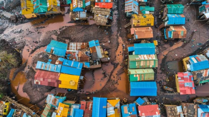
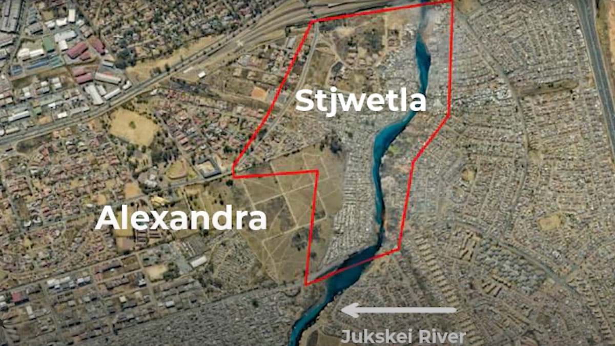
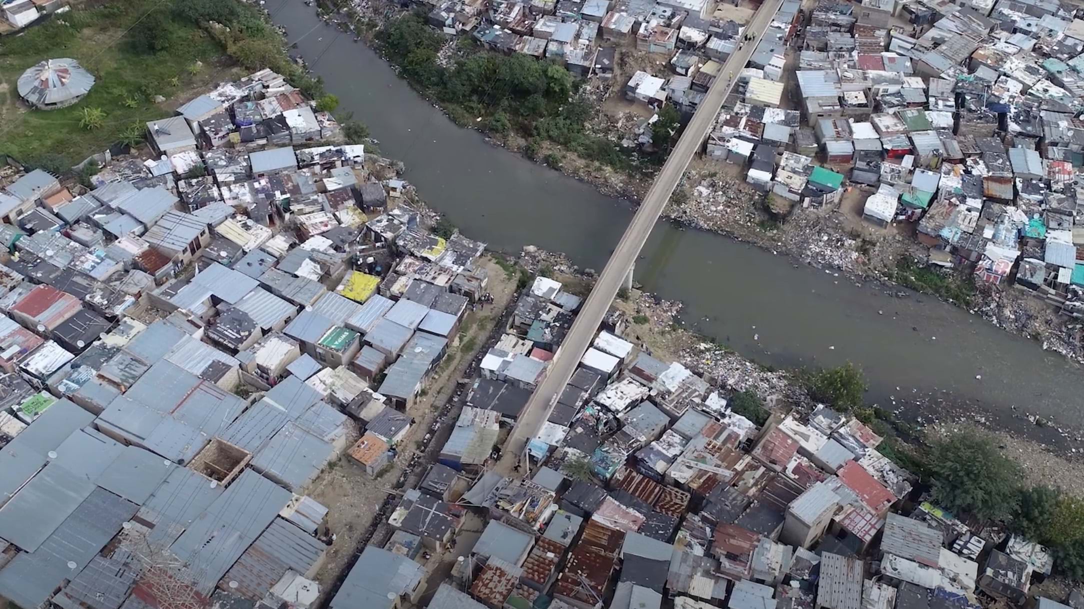
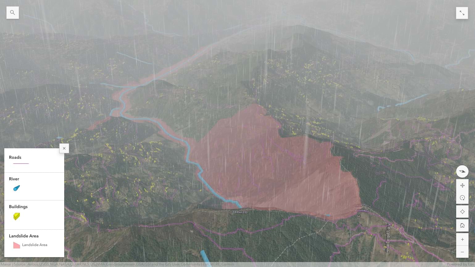
It’s become a familiar calamity in Johannesburg’s Alexandra Township: heavy rainfall and severe flooding destroying the informal settlements built alongside the Jukskei River, sometimes taking whole homes in the process. To make the situation worse, local communities often don’t have the means to keep information on historical flooding or foresee the potential amount of damage that flooding can cause, making it harder to anticipate and prepare for future events.
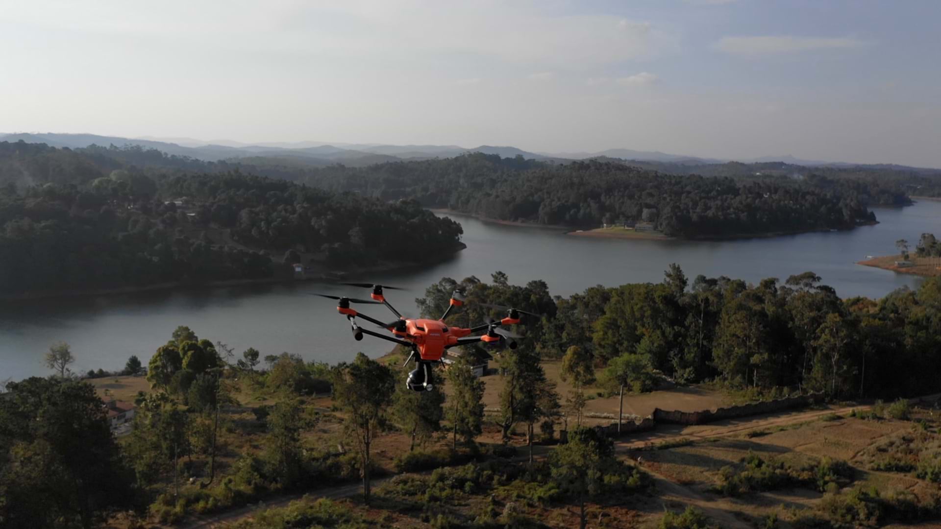
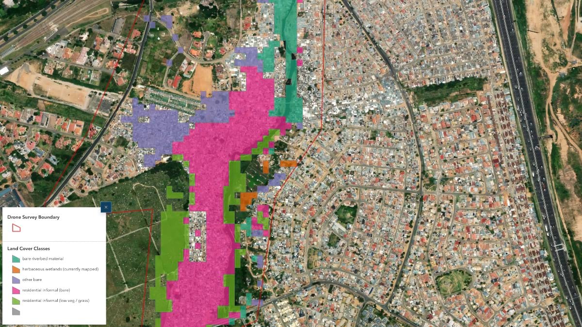
After severe flooding last February, a team of local technologists called South Africa Flying Labs, proposed a new approach. The team is the local branch of the global Flying Labs Network. The network comprises innovation hubs that equip their communities with the technology, skills, and connections helpful for solving social and environmental problems, often with the aid of drones. In collaboration with QP Drone Tech and in partnership with UNICEF South Africa and insurer Santam, South Africa Flying Labs worked with the community to fly drones over the flooded zones, mapping them to tell what parts of the riverbank were most affected and are now especially vulnerable to future flooding and fire.
“People were amazed by the kind of data, the kind of insights that we can derive from drone data,” said South Africa Flying Labs operation director Jack Shilubana in a project recap.
Queen Ndlovu, director of South Africa Flying Labs, points to another important component of the mission, too: the young, unemployed Alexandra residents who were enlisted to examine the drone data.
“You invest another day in getting them onboarded on the technology, showing how you turned the data into maps and models—how they can create a flood model or a fire model out of that for their communities,” she said. “They’re going to see that and go, ‘This is really interesting, this could be a career path.’ For me, it’s all about empowering.”
The Flying Labs Network, officially founded in 2016 and now spanning more than 40 countries globally, has used drones to help with everything from topographic mapping to recovery efforts to precision agriculture. But the network is also part of a shift in international development that extends beyond technology.
Under what is called an “inclusive networks” model, each lab operates as an independent licensee, run by a local for-profit, nonprofit, or academic organization. A typical lab might serve as an incubator and training center, teaching drone piloting and geospatial analysis. Flying Labs also cultivates in-country partnerships and decides with local partners when and how to use drones to address challenges related to the United Nation’s Sustainable Development Goals. At the same time, each lab can tap the knowledge of the global network of Flying Labs and WeRobotics, which provides resources and supports technical and organizational efforts.
Sonja Betschart, a cofounder of WeRobotics, the US/Swiss-based nonprofit behind the Flying Labs Network, compares the model to that of the TEDx Program, with its locally run conferences. By cultivating a global web of local technology experts who can solve problems across their communities’ agricultural, health, and entrepreneurial sectors, the hope is that Flying Labs chapters can become the primary sources for mapping, remote sensing, and robotics in their own countries, instead of foreign consultants who often parachute in with little local knowledge or interest in local stewardship.
When there’s an emergency, Betschart said, local Flying Labs chapters can “deploy quickly—they’re already part of the community, and they know how to secure flight permissions in the countries already or can get them swiftly because they already work with the civil aviation authorities.”
The model is part of a push in development circles for localization, shifting not only technology to local organizations but also the ownership of knowledge and responsibility. “The international aid and development sector is slowly changing when it comes to the mindset of working with local organizations and seeing them as being as efficient as—if not more efficient than—international experts,” she said.
Local actors, such as governments, need convincing too, and Betschart says Flying Labs has been lately focused on cultivating stronger ties with emergency management officials and helping governments develop disaster plans. In the immediate wake of a flood or a hurricane, regulations—or the lack thereof—can interfere with efforts to fly drones to look for survivors, or build detailed maps for recovery efforts.
“If there’s no disaster management framework in a country, the Flying Labs and the local and global NGOs [nongovernmental organizations] in there are all operating in a governance vacuum,” she said. “The only framework is the one that’s provided by international sectors, which is exactly what we’re trying to sort of shift away from.”
To address this, WeRobotics; Flying Labs; and like-minded organizations, including MapAction, are teaming up to establish regular regional meetings around the use of drones and geospatial technologies, specifically to allow national disaster management authorities to exchange best practices and strengthen national and regional disaster risk management frameworks.
Betschart has also been urging other international organizations to reconsider their top-down approaches and explore Flying Labs inclusive networks model. A growing number of NGOs are tapping into the Flying Labs Network for local drone projects, instead of relying on international experts or in-house tech talent. “This keeps on being one of our key focus areas: not just doing the work by itself but also changing mindsets while doing it,” Betschart said.
Betschart noticed her own mindset starting to change over a decade ago, while she was working for a drone data startup. At the time, much of the conversation around unpiloted aerial vehicles (UAVs) focused on military uses and on wealthy markets. The industry—and international aid organizations—paid little attention to the more democratic potential of drones. Sure, they were a powerful technology for geospatial observation—for assessing hurricane damage or spotting illegal gold mining—but they also could represent something more: a way to shift that power to the people who need it most.
“Sometimes just an aerial image can hold so much power in terms of evidence, in terms of data and decision-making,” she said. “The power this has for a lot of smaller organizations, for communities, for anyone who doesn’t have the means or access or both to satellite data—this can make a huge difference.”
With a few colleagues, including one of the cofounders of WeRobotics, they started an association called Drone Adventures, focused on humanitarian and development uses for UAVs. Betschart and her colleagues traveled to over a dozen postdisaster and conservation projects in Africa and Southeast Asia. In each place, they would spend a day at the local public technical university to showcase their work and their gadgets, often to wide-eyed students.
In 2015, in the wake of a devastating earthquake in Nepal, Betschart and her colleagues met the founders of another humanitarian drone group, called UAViators. Everyone saw a void that needed to be filled between the drone industry, the geospatial industry, local experts, and the nonprofit and private sectors. “That’s when we started thinking about, how can we create more access? And the four of us decided to found WeRobotics,” Betschart said.
Nepal, Tanzania, and Peru would become the testing ground for more Flying Labs branches in places experiencing cascading risks, rapid development, and serious environmental threats. Drones would be central, but instead of focusing on technology, the colleagues wanted to emphasize a holistic approach, built around local capacity and collaborations. “From the beginning, our concept was always to say, We’re not going to reinvent the wheel, we’re just going to try to fill in the void of facilitation and help connect the dots,” Betschart said.
After helping set up the first three labs, Betschart and her colleagues switched to a social franchising approach they named the inclusive network model in 2018, shifting more power to the labs and allowing local organizations to apply to join. By the end of that year there were 15 labs in countries across Africa, Asia and the Pacific, Latin America, and the Caribbean.
“It confirmed our proof of concept,” she said, “that we didn’t have to set up anything, and that labs would set up themselves by joining the network.”
In Kenya and Namibia, Flying Labs has collaborated with local farmers and agricultural experts to use drones for crop monitoring, soil analysis, and irrigation management; elsewhere, Flying Labs branches have investigated using drones for medical deliveries in Nepal, the Dominican Republic, Papua New Guinea, Uganda, and the Philippines. In Tanzania, the local lab and its partners deployed drones equipped with specialized sensors to identify and map mosquito breeding sites, to target mosquito-control efforts more effectively, and reduce the spread of diseases like malaria and dengue fever.
For all the tech, Betschart says, projects like these depend on close relationships with local stakeholders. As part of a months-long application process, a potential Flying Labs operator must show how it plans to collaborate with partners in government, civil society, and academia. Stakeholder and community engagement can represent around half of the work that each lab does, she says, and it’s the first bullet point in the Flying Labs Drone Code of Conduct for Social Good.
“What we’ve learned is that the earlier you engage your decision-makers, the more success you’re possibly going to have to turn the actual data into decisions and evidence-based decision-making at the end,” she said.
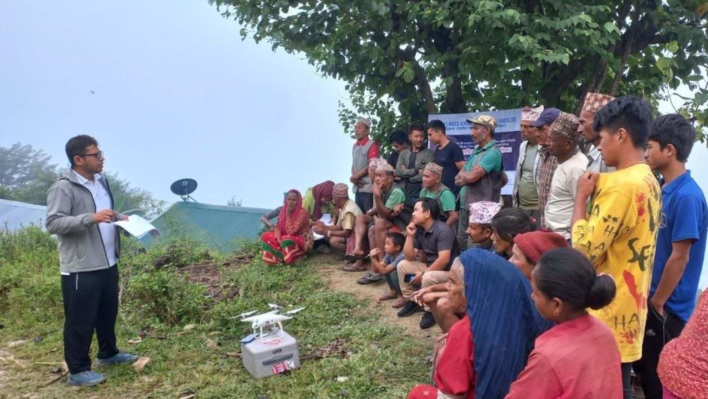
That also means holding community meetings, “explaining what the project is about, what the technology is about, what data will be acquired, hearing their questions,” she said. “People start creating a relationship with the data, and they feel like they have been part of the process of creating it.”
It’s not that sexy to talk about or invest in stakeholder or community engagement, but it's essential for success.
And once the data has been processed, often on-site, it “can be used to start the discussion around the decisions that need to be taken. People will not be surprised when the decision comes because they can be part of the process,” she said.
Local knowledge also enriches the best aerial data. A National Aeronautics and Space Administration (NASA)-funded project she worked on in rural Tanzania in 2018 was using drones to get “ground truth” data from satellite imagery. The data suggested the territory was planted with maize. It turned out that the area in question was an intercropping of maize, beans, and sunflowers. The drone data provided context to the satellite data, informed by on-site remote sensing. The local community members shared additional insightful information that aided the data analysis, including infertile areas—the result of prior floods—not visible in the imagery.
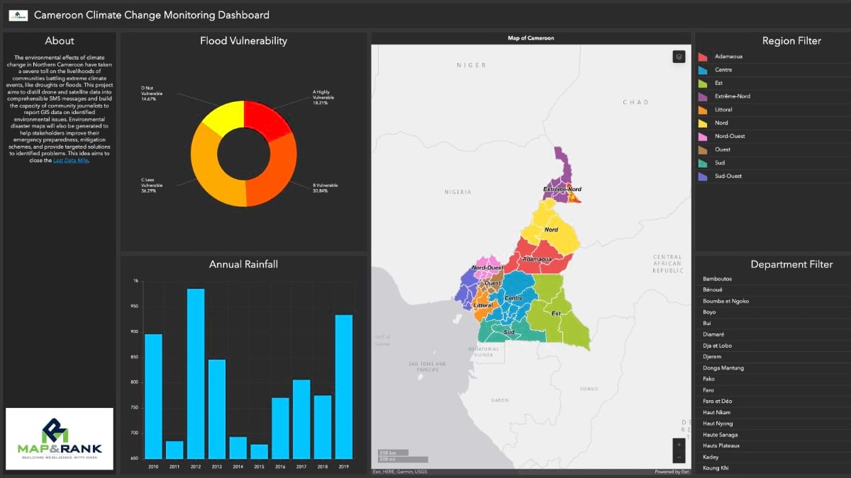
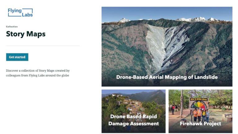
During a project, software including ArcGIS Online and ArcGIS StoryMaps allows each lab to easily share data, 3D models, and maps with the appropriate stakeholders. Afterward, technical use case reports, distributed across the Flying Labs Network, help other labs replicate approaches rather than having to ask: How was the data collected and processed? What were the outcomes? What were the challenges and failures?
For many labs, one persistent challenge has been convincing skeptical government officials to stop relying so heavily on foreign organizations and tap into local talent. Faced with a regulatory conundrum, officials often “will fly in someone from the UK or from Europe or from the US or the World Bank to help them figure it out,” Betschart said. “But they have the best people in-country.”
After years of top-down development projects buoyed by all sorts of high-flying technologies, some governments are reaching for more on-the-ground expertise. In 2020, Senegal Flying Labs worked with the Senegal Ministry of the Environment and Sustainable Development to run a drone pilot project, helping park rangers pay attention to one national park. Impressed, the ministry decided to buy a fleet of small drones and enlisted the lab to train the rangers and serve as a persistent drone resource.
“Senegal Flying Labs staff are the ongoing support, and if the park rangers have new applications that they want to learn about, they’re there to support them,” Betschart said. “It’s not someone coming in, teaching, and then leaving.”
Learn more about GIS solutions for humanitarian assistance.