Mike Schonlau, administrator for the GIS department of Douglas County, Nebraska, knew there was potential for severe tornadoes in the days leading up to April 26, 2024. When an emergency operations center was activated that afternoon, Schonlau and another staff member made their way to the center to monitor the situation and prepare to assist first responder agencies. There, everyone hunkered down to await the oncoming storm.
Schonlau’s department oversees core GIS services for the whole of Douglas County, which includes the city of Omaha. The department primarily provides GIS support to other departments and agencies, including managing multiple databases and over 100 web apps and mobile apps with ArcGIS tools. This infrastructure, as well as county employees’ familiarity with ArcGIS, is invaluable in emergency situations such as tornadoes and floods, when GIS is instrumental both in responding to a disaster and in recovery. During the recovery process, an accurate assessment of damage is crucial in ensuring that local government receives reimbursement from the Federal Emergency Management Agency (FEMA) for recovery efforts in the aftermath of an emergency event such as a tornado.

As they waited, Schonlau and his staff set up a web app using ArcGIS Online that would help first responders coordinate and communicate with the public. Having been through similar storm-related emergency events, as well as floods, they also prepared to deploy field data collection tools such as ArcGIS Survey123 and ArcGIS Field Maps.
“There was a damage assessment reporting form for the field we had used successfully during a flood event in 2019,” said Schonlau. “We got to work in the afternoon of that Friday making sure that was working and making sure the content of the survey was up-to-date.”
Schonlau’s team also started building a web app using ArcGIS Experience Builder that would include dashboards to display damage reports called in by Douglas County residents. It was vital that the team have all this in place when the storm finally hit, so staff would be able to provide real-time data and support for first responders working in the field.
From Preparation to Action
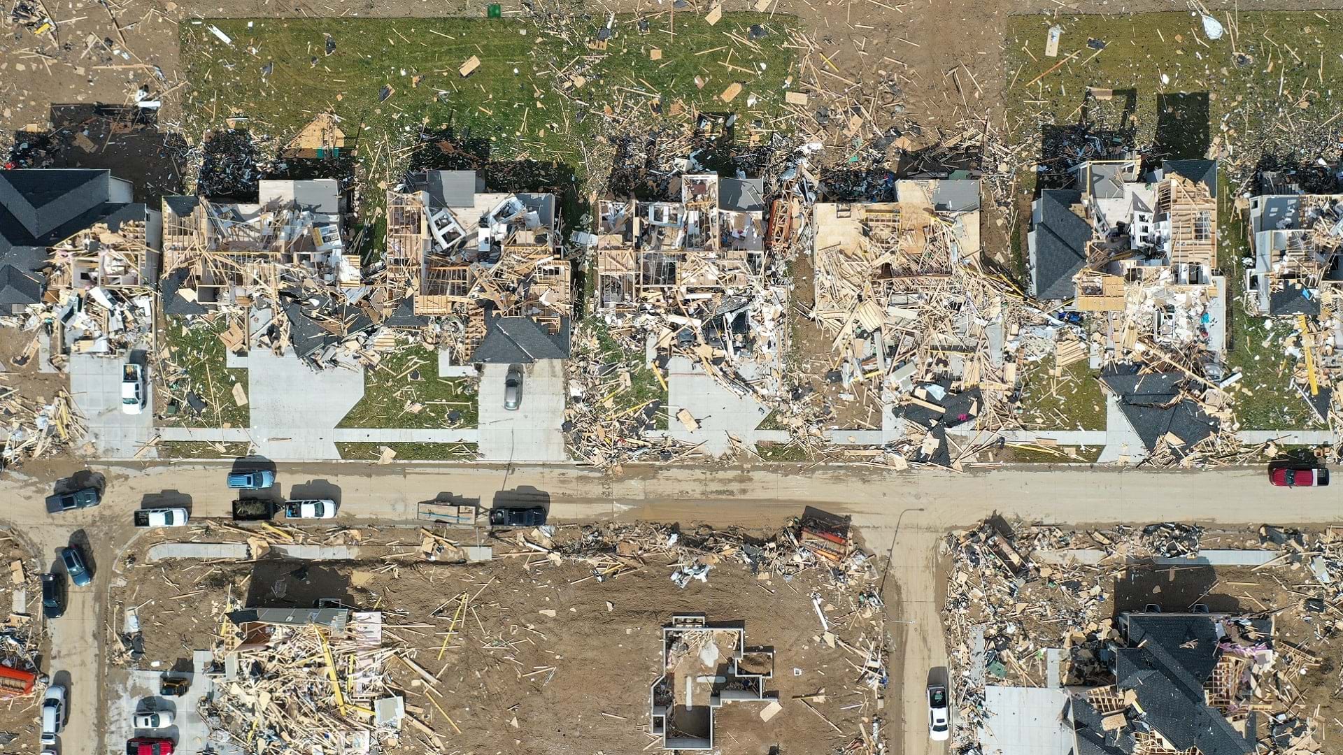
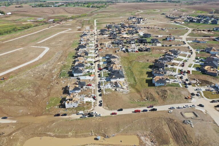
Finally, on the evening of April 26, nine tornadoes touched down near Omaha, Nebraska. They tore across the landscape for almost five hours and destroyed nearly 200 homes across eastern Nebraska and western Iowa, often leaving behind only basements. Almost 1,000 homes in total sustained some level of damage.
The tools Schonlau and his team had prepared went into effect as first responders sprang into action, assisting injured residents and collecting information on the tornadoes’ impact.
“We knew from first responder reports that there had been considerable damage,” Schonlau said. “But it was late at night. We couldn’t do a lot that evening after the storms.”
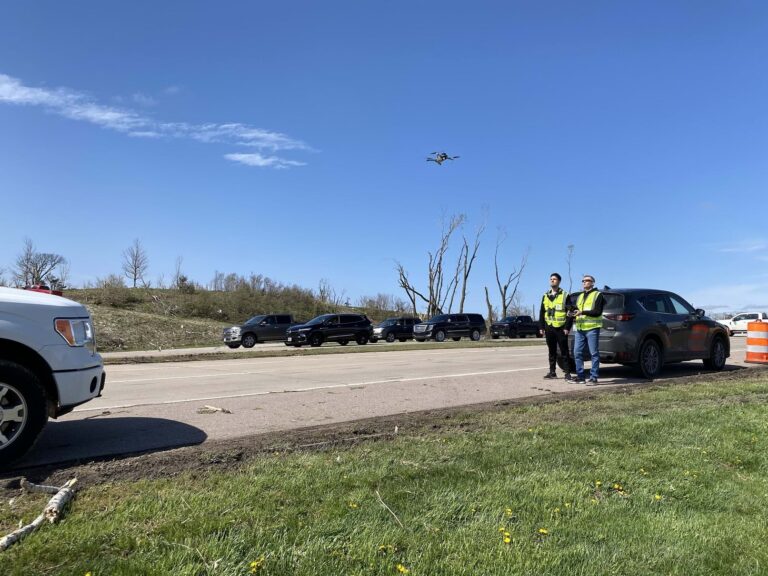
First thing the following morning, however, Schonlau’s team went out to capture drone imagery of impacted areas. Thanks to first responder field reports, they knew exactly where to fly and what images they needed to capture to obtain a full picture of the aftermath.
On top of National Weather Service reports, GIS department staff used this imagery to ascertain the boundaries of the damaged areas, a crucial step in the recovery process.
“We were able to draw a tornado damage area in ArcGIS Pro, and that area served as our focus point,” said Schonlau. “We then included that area in the web [app] that we had built.”
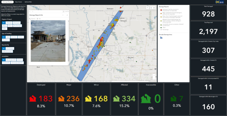
As residents began to call into the county’s 2-1-1 emergency line to report damage over the course of the day, operators input this data into the ArcGIS Survey123 form that Schonlau and his team had set up before the tornadoes struck. This was linked to the web app so that damage assessments would automatically populate within the affected area, allowing the GIS department and first responders to manage access to damaged areas and property. The app also included information—such as the types of structures damaged and the severity of the damage—and photos from the field, if available.
“In addition to [residents] and 2-1-1 call takers, we started to get emergency volunteers and inspectors from the city and county who were actually doing more formal damage assessments,” said Schonlau. “They were doing this through mobile apps we’d built, and all of that information started to show up in our web [app].”
Assessment and Recovery
In the following days and weeks, a picture of the damage the tornadoes had done became clearer.
“At first it’s really just the triage,” said Schonlau. “But then you have a little time to think and get more organized with what you’re doing, and that’s what happened here. We provided more guidance and organization to how the data was being collected and reported.”
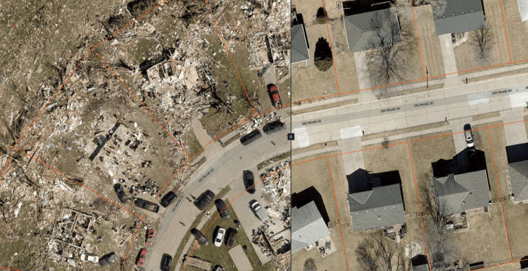
One of the most valuable features communicating the extent and nature of the damage was a swipe tool Schonlau and his team built into the web app. The tool showed what the tornado-affected areas had looked like just before the storm compared to immediately afterward. Luckily, aerial imagery of the whole county had been collected only a few weeks before the tornado, making the comparison especially valuable when the City of Omaha began to issue permits for rebuilding.
On April 30, just a few days after the tornadoes struck, Schonlau and his team presented the web app to the Omaha City Council and Douglas County officials, supplying an overall picture of the damage that had occurred. The web app was also critical in communicating with FEMA, which provided recovery assistance in the wake of the storm.
When it comes to responding to storms or other natural events that cause this kind of damage, Schonlau emphasized, the name of the game is preparation. Using ArcGIS Solutions for damage assessment, for instance, was invaluable in speeding the county’s deployment of GIS resources. But the county has also been through several storm- and flood-related events in recent years that prepared the team to know what to expect. And having the right tools in place ensures that Douglas County will be ready when the next storm hits.
“We had built tools to collect data in all of these instances, and we’ve tried to take notes on what worked, what didn’t work, what could be more efficient,” said Schonlau. “How do we do things more quickly? How do we report things more accurately? We’re always examining that.”