The Massachusetts Department of Transportation (MassDOT) administers roadways and bridges across the commonwealth, from state highways to local intersections. This infrastructure generates a massive workload as roads deteriorate due to traffic or weather and as new roads are added to the network.
In 1973, to help remedy this issue, Massachusetts instituted what became known as the Chapter 90 Program, which provides aid to municipalities looking to improve local roads and bridges or invest in constructing new ones. The program was designed to be bottom-up: Municipalities would evaluate their individual transportation needs and goals, and MassDOT would then agree to allocate funding. Municipalities pay for approved improvements and investments up front and later receive reimbursement.
Because of its scope and complexity, however, MassDOT developed a significant backlog. Chapter 90 funding is based on factors such as road mileage and local demographics, all of which need to be verified and kept up-to-date for a municipality to receive funding. To help organize the Chapter 90 process, MassDOT turned to ArcGIS Roads and Highways.
“A lot of the data collection went a long time without getting updated, and that would lead to towns not getting their fair share of funding,” said MassDOT lead GIS developer Carl Hughes. “It was just an incredibly complex and [time-consuming] process for sending those updates. Anytime a town built a new road, it would be a manual process of verifying, updating the database, and pushing that [data] up or downstream in order to get it reflected.”
Kevin Lopes, MassDOT director of GIS and research, added that paper-based documentation slowed things down. “That’s how we started this process,” he explained. “It evolved over a couple of different iterations, and then the platform changed once we moved to Roads and Highways.”
Unlike many other GIS products, Roads and Highways operates on a linear referencing system based on measured values. This approach is designed to help organizations with linear assets such as streets and railways. It also makes Roads and Highways appealing to departments of transportation.
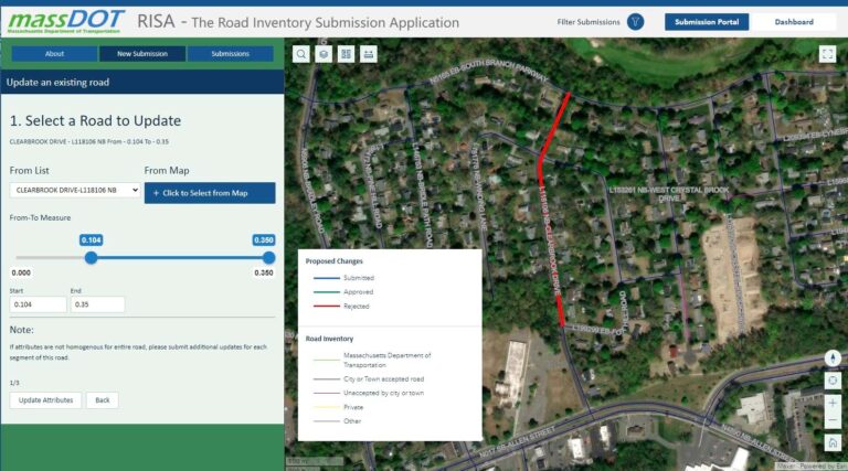
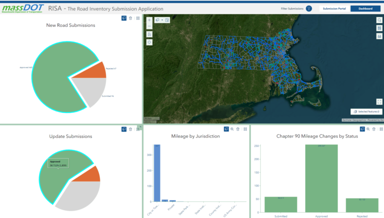
MassDOT took this functionality a step further with its Road Inventory Submission Application (RISA). This web app—created using Roads and Highways—allows municipalities to directly communicate any road network updates to MassDOT. It’s an efficient process that provides the department with accurate reimbursement data for eligible infrastructure projects.
A Fitting Solution
One of the problems with the system that was in place prior to RISA, Hughes explained, was this: Because of municipalities’ differing resources, verifying what each city and town actually needed was a laborious process.
“We understand [that] every town is different,” Hughes said. “Some are bigger, some are small; some have a good idea of what the road network looks like, some don’t. Some have public works departments that have GIS expertise, and some don’t. We wanted to make something that was easy enough for anyone that was aware of the process to do it.”
Because of the wide-ranging needs of communities across Massachusetts, MassDOT GIS staff sought to make the app as accessible and transparent as possible. RISA can be found on MassDOT’s GeoDOT Local platform, a site created with ArcGIS Hub that hosts information about various transportation-related resources for Massachusetts cities and towns.
When using the app, a municipality representative fills out a RISA application with information about proposed road network updates. Next, MassDOT staff review the application and approve or reject it, whichever is appropriate. Once an application has been approved, a script written by the MassDOT team incorporates the updated data automatically into the Roads and Highways interface.

“RISA tightly integrates with the Roads and Highways workflow without having to go through the traditional editing mechanism,” Hughes said, describing the app as a “silent workhorse.”
With a clear picture of proposed road network updates, MassDOT can use this data to allocate Chapter 90 funding, which is then distributed to local governments once a project is completed.
Getting the Word Out
Now that RISA is in place, the biggest challenge for MassDOT has been making sure that all of Massachusetts’ 351 municipalities are aware of and using the system. If a town updates its road network without submitting the proposal via RISA, that town risks not getting the reimbursement it may be entitled to receive under the Chapter 90 Program. This is why MassDOT has made outreach a priority—holding seminars, presenting at conferences, and attending local government meetings to raise awareness of the program.
“We’re not getting submissions from 351 cities and towns, but it’s certainly gone up since we initiated this process,” Hughes said.

RISA’s success has inspired the creation of several other apps that allow the public to report road changes or updates to MassDOT. These apps include Road Inventory Error Reporter, Bike Update Reporter, and Walk/Pedestrian Update Reporter. MassDOT reviews and verifies users’ submissions and uses them to update any public maps. This is a game changer for someone who may not be familiar with GIS to communicate actionable geospatial information, Hughes said.
“Roads and Highways is this powerful GIS tool that can also be adapted and leveraged for real-life practical applications, not just for GIS professionals,” Hughes said. “You don’t have to know what a ‘from’ or ‘to’ measure is. You just have to say, ‘I know what’s on the street and I know it’s from here to here.’ And then that translates down through the Roads and Highways technology into what we need on our side for reporting purposes.”

