Outfitted with the cowboyish nickname “the West’s Most Western Town,” Scottsdale, Arizona, is an oasis on the northern edge of the Sonoran Desert despite the challenging conditions a desert environment can entail.
Meeting the needs of Scottsdale’s more than 240,000 residents—as well as the millions of visitors who stop in annually—requires dependable amenities and services. To its benefit, the city has a long history of integrating GIS technology with its operations. In fact, Scottsdale moved to an ArcGIS framework in the early 2000s.
GIS often plays the role of behind-the-scenes hero, and it’s not surprising that many people in Scottsdale don’t realize the extent of the city’s geospatial information reach—even as it touches many key city services. The Scottsdale GIS team now maintains technology that includes more than 130 enterprise feature classes that are used by many essential city departments, ranging from economic development to police, fire, transportation, and water.
Mele Koneya is a GIS analyst at the City of Scottsdale, where he’s been working with a nine-person team to support the city’s geospatial needs for the better part of two decades.
Staying True to “We Care for You”
Virtually all aspects of city infrastructure are considered important, but public safety is one of the most critical. It’s here that Scottsdale residents and visitors are served by the Scottsdale Fire Department, which dispatches aid from 15 stations around the city. The department, which has the motto “We Care for You,” covers a 184.5-square-mile (477.9-square-kilometer) area that includes urban areas and the abutting McDowell Sonoran Preserve.
GIS services provided by Koneya and the Scottsdale GIS team play a key role in supporting these important responsibilities. These include determining standards of coverage—the baseline service levels that the fire department can provide. For example, Koneya said, the GIS team used drive-time estimates, several years’ worth of incident response data, and a target response time of less than four minutes to identify optimal locations for one-third of the city’s fire station locations.
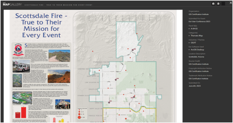
Koneya captured the exceptional work of the fire department and its relationship with GIS in a map that won a first-place award from the GIS Certification Institute. This map demonstrates how—even when hundreds of thousands of visitors flock to the city during events such as the Barrett-Jackson Collector car auction or the WM Phoenix Open golf tournament—the fire department maintains its high standards. A geospatial focus helps the department stay true to its mission despite workloads that can climb from a daily average of 110 calls for assistance to nearly double that during peak activity events.

Troubleshooting ArcGIS Field Maps During Events Season
Koneya is proud to participate in Esri Community, where he finds support from the global Esri user community while solving problems on behalf of Scottsdale. Koneya has contributed hundreds of posts in his nearly 15 years of being part of Esri Community.
During the lead-up to Scottsdale’s busy 2023 event season, Esri Community connections helped Koneya and his team troubleshoot a significant problem. Koneya explained, “During our event season, where we were supporting our fire and police crews at the WM Phoenix Open—a major golf tournament in Scottsdale—we ran into some issues we weren’t aware of with a tracking view in ArcGIS Field Maps. A lot of that technology was new to us, and because I and my coworkers are [Esri] administrators, it worked fine for us. Then we handed it off to someone else and it didn’t work for them. I was like, ‘What are we missing here?’”
Stopped in their tracks and unable to figure out how to get location sharing to work for non-administrator users, Koneya turned to Esri Community. He uploaded images explaining his quandary in a post, “Location Sharing is Not Available.” Within a few hours, an Esri staff member replied. The connection was made and an hour later, Koneya had a solution.
Getting Help from Esri Community
Koneya has more stories about solutions found on Esri Community, including resources on ArcGIS Experience Builder and ArcGIS Monitor that helped the city’s GIS team improve service performance monitoring in 2024. Koneya also cited the ArcGIS GeoEvent Server Blog articles and posts by Esri product engineer RJ Sunderman that aided team members while they learned the software—supporting their ability to track more than 200 police officers and fire department staff members all at once.
From participating in ArcGIS Ideas exchanges to finding information on the Community Help Documents page and in Community Blog articles, Koneya has gained a lot of value from Esri Community.
“One of the things I say to people is that you can’t do it all by yourself,” he said. “I’ve been doing this for almost 30 years, but I don’t know everything. Nobody knows everything. Esri Community is important to be part of so that we can share and learn from others.”


