
For telecommunications providers, it is vital to be able to accurately evaluate customer demand. Telecommunications services are increasingly necessary all over the world to provide support that ranges from business operations to disaster management to social connectivity. But how can businesses tell, with the greatest degree of accuracy, where their services are most needed or wanted?
That is exactly the challenge faced by Turkcell, one of the leading telecommunications companies based in the Republic of Türkiye. Turkcell currently provides digital services in four locations—Türkiye, Ukraine, Belarus, and Northern Cyprus—including fiber-optic internet, a service the company is eager to expand.
To determine the best locations for fiber-optic cable investment, based on factors such as the locations of its current customers and existing infrastructure, Turkcell turned to GIS and machine learning. With tools such as ArcGIS Spatial Analyst and ModelBuilder in ArcGIS Pro, Turkcell hoped to gain more insight into not only the most profitable places to expand, but also to predict rates of return for sales after installation.

According to Turkcell expert geodata scientist Gülnur Özbaş, this kind of detailed analysis is likely to become increasingly common in a highly competitive industry. “The use of efficiency-enhancing decision-support mechanisms—such as GIS, artificial intelligence, big data analysis, spatial data analysis, machine learning, and spatial intelligence—are rapidly becoming an essential component in the business world,” he explained.
Turkcell has long been in the practice of assessing market demand with geospatial tools, but applying machine learning methods enables the company to act with more precision when it comes to fiber optic expansion.
Algorithms, Augmentation, Analysis
The first step in leveraging these tools to expand Turkcell’s services was determining the best algorithm for the work. The company ultimately settled on the XGBoost algorithm, a software library that could process a huge amount of existing data about current and prospective customers, including internet speed, income indicators, socioeconomic development, regional statistics, and infrastructure location.
For the analysis, Türkiye was divided into 200-square-meter (about 656-square-foot) grids. Advanced geographic analysis was then used to assemble these grids with an iterative process that was automated using ModelBuilder in ArcGIS Pro. More than 292,000 grids, which included about 10.5 million buildings, were created and millions of data points were processed.
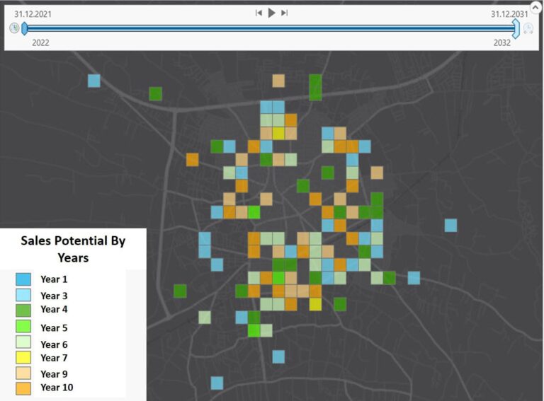
Using a grid analysis method in ArcGIS Spatial Analyst and ArcGIS Geostatistical Analyst, the data was processed, refined, classified as qualitative or quantitative, and analyzed. Results were displayed in a web application using ArcGIS Online, with a time slider that shows projected increases in Turkcell subscribers. By analyzing existing subscriber rate data with machine learning, Turkcell can more selectively focus on areas to expand its fiber-optic network that would provide the greatest return on investment.
From Neighborhood Scale to Building Scale
Turkcell also plans to further focus its analysis, hoping to identify which specific buildings within the area it services would benefit most from fiber-optic expansion.
The company’s senior planning specialist Burak Gülseren shared that refining the data scale to that of individual buildings enables more detailed analysis. “With new technological developments, it’s inevitable that there will be a transition from neighborhood scale to building scale in the determination of optical fiber investment areas.”
Ultimately, the more granular a picture Turkcell can get in its analysis, the more effectively it can decide where to expand and how to market its services within individual neighborhoods.
“Analytics projects and studies using GeoAI will become increasingly important at Turkcell because it’s critical to the growth of our business,” Özbaş said, explaining that geomarketing, the practice of using geographic information to inform a business’s marketing strategy, will play a significant part in the implementation of Turkcell’s future plans.
“By using these advanced technologies, it’s now possible to analyze complex and large-volume geospatial data to make data-based, objective decisions for business development,” he added.
