By the time Parker Hornstein graduated from Washington College in 2017, he had already helped the State of Maryland make roads safer with his geospatial analytics work. Not as an intern. Not as a theoretical class project. Hornstein was a paid employee of Washington College’s GIS program.
“That’s marketable work on my résumé,” he said of what he did while a student at the school. He described his role then as “an actual analyst doing analyst-level work.”
Washington College doesn’t currently offer a GIS major or minor. However, the school’s GIS program has been introducing students across academic disciplines to the problem-solving technology since January 2004. That’s when it was incorporated into the Washington College Center for Environment & Society.
Shortly after Hornstein graduated with a degree in computer science, Esri hired him, first as an intern and then as a full-time employee. Now, he’s a senior solutions engineer with Esri’s national government team based in Colorado. He credits the college’s “learn by doing” approach. “We’re going to teach you how to learn these things, rather than teach you these things,” he said of the school’s ethos.

Learn by Doing
Washington College was founded in 1782 on the Eastern Shore of Maryland with early help from an investment by America’s first president. These days, the small liberal arts institution prides itself on experiential learning. The GIS program, for instance, teaches students—no matter what they study—how to use geospatial technology in real-world situations by working on contracted projects.
“If you can learn how to use these tools, you can apply it to your future aspirations,” said Sean Lynn, Washington College’s GIS program manager.
The grant-funded program brings in about $1 million in annual revenue from its contracted projects. It pays its own rent and discounted Esri technology costs, writes its own grants, and covers the payroll of its student interns and several of the professionals who work alongside them in the lab.
About 10 student interns typically work in the lab during the summer, and anywhere from 15 to 30 work during the academic semesters. The need ebbs and flows with contractual requests.
One of the biggest contracts the program has is with the Maryland Department of Transportation through the Maryland Highway Safety Office and State Highway Administration.
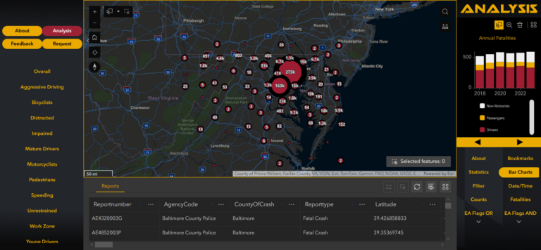
“They came to us with a problem and we provide them ongoing solutions,” Lynn said. In that case, and with the Federal Motor Carrier Safety Administration, Washington College students developed dashboards with ArcGIS Dashboards to provide statistical and geospatial views of commercial vehicle crashes. In addition, the program has produced physical and digital maps for the Maryland agency to use in its efforts to achieve the goal of zero traffic deaths statewide using ArcGIS Pro and ArcGIS Online.
Often, agencies seeking help lack the resources, personnel, or time that the program can provide for analysis or application development. The program’s lab also works with small communities and organizations, including the Town of Chestertown, where the college is located. Incremental projects are priced at anywhere from $100 to $500 each. The program has also helped instructors on campus with their own research, including professors of sociology and anthropology.
“We’re here to help,” Lynn said, calling theirs a cost-effective solution.

The program gives students a starting point on the basics, including familiarity with ArcGIS software such as ArcGIS Pro, ArcGIS Online, ArcGIS Survey123, and ArcGIS Experience Builder. They also learn how to use Excel to make pivot tables, expressions, and functions, as well as how to manage servers and use Python coding in their GIS work.
Hornstein, for one, worked on a variety of projects while he was a student, including routing analysis and helping determine where police should set up checkpoints based on the number of people arrested for driving under the influence (DUI). Every year, he and others in the program also updated a map of all the Irish bars ahead of the Saint Patrick’s Day holiday to prepare public safety agencies on the lookout for drunk drivers.
“It was real work,” he said. “This is what real data looks like.”
And it can be messy. Data cleanup and geocoding can be a challenge for any analyst. With the freedom the program afforded him, Hornstein developed a way to automate some of the more tedious geocoding processes required using APIs—figuring out the solution on his own and helping future student interns in the process.
“We’re prepping them for the real world,” said Lynn. Or rather, he emphasized, “they’re prepping themselves for the real world.”

Expanding the Use of GIS
Lynn himself was a summer student intern in 2010, 2011, and 2012 in the GIS program while attending Coastal Carolina University, earning a degree in computer science and later an MBA. He returned to Washington College in 2015, eventually serving as the program’s interim director until this year. Longtime geospatial technology professional and academic administrator Tarek Rashed, PhD, was hired as the program director in early 2024.
Together, Rashed and Lynn hope to expand the program’s reach and influence, including rebranding it as the Geospatial Innovation Program (GIP). They also hope to establish a minor in GIS, offer GIS certificates, and eventually make the whole school a spatially enabled campus with geospatial thinking infused in every aspect of its operations.
“GIS can be in every single thing,” Rashed said, adding that even the dance program could include a GIS element such as mapping choreography on stage. “I’m a GIS believer.”
Spreading the geospatial technology gospel has involved an increased effort to educate more of Washington College’s staff, students, and faculty about the value of GIS and how it can help them. Lynn likens it to the early days of computer science as an academic track. Today, everyone knows what a computer science department is and does, but it took years for it to gain that recognition. Lynn said he’s seeing the value of GIS grow at campuses around the nation.
“The opportunities that lead from the work that we’re doing has always been something that I’ve treasured in my time here,” Lynn said.
At its core, the program provides a valuable opportunity to help communities and organizations in need of analysis, and provides students a place to hone skills that are landing them rewarding jobs.
“Just because you do it in the classroom doesn’t give you the experience necessary to do it in the real world,” Lynn said. “We’re training the GIS professionals of the future.”

