When cracks appear in a newly constructed home’s pristine walls, or when freshly laid floors start to appear uneven, a homeowner’s worst fears can come to life. Residential structural warranties offer builders protection if unexpected defects affect a home’s load-bearing elements.
As a provider of 10-year structural warranties for residential home builders, 2-10 Home Buyers Warranty (2-10) provides warranties for one in every five homes built in the conterminous United States.
When a homeowner submits a claim under the home’s structural warranty, the evaluation process begins with an on-site inspection by a structural engineer. The engineer looks for evidence of a shifting foundation—such as sagging floors or cracks in drywall—and surveys the elevation at key points. This determines how much the foundation has moved from its original state—or “tilt and deflection,” in civil engineering terminology. Although the foundation’s original condition is not usually documented, engineers typically assume that the foundation was built within 0.75 inches (about 1.9 centimeters) above or below levelness/flatness.
The engineer then enters the measurements into tilt and deflection analysis software and generates a report for the claims adjuster who manages the structural claim. If the tilt and deflection measurements meet the American Society of Civil Engineers and Post-Tensioning Institute’s standards for excessive foundation movement in a home, the structural claim is approved.
In 2018, 2-10 was using a third-party engineering firm’s software for its tilt and deflection analysis, but the firm was ceasing operations. The software was antiquated, requiring multiple programs to complete the evaluation process. The firm offered to sell its proprietary software, but when 2-10 staff realized they could build a state-of-the-art software program for a quarter of the cost, they decided to bring the tilt and deflection analysis process in-house. To build its in-house software, 2-10 selected Esri partner Argis Solutions.
Cheaper, Faster, More Accurate, and Less Labor-Intensive
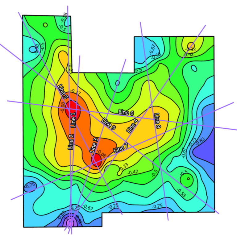
From 2018 through late 2019, Argis worked to create an ArcGIS Pro extension containing a customizable tool that takes accurate measurements of a home’s elevation and creates a small-scale elevation model of the foundation.
With the home survey measurements, 2-10 engineers use the tool to draw lines across the elevation model. These lines help engineers determine the most significant foundation deflections and tilts. The engineers then generate a custom report with easy-to-read graphs, tilt and deflection ratios, and offset calculations for deflection using the computations and imaging that the program creates.

“With this tool, I can do an analysis in half the time it took with our old process,” said Sam Vialpando, risk management engineer for 2-10. “When we are handling a yearly volume of 200–400 claims, that adds up to significant time savings.” The more streamlined evaluation process allows staff engineers to focus their time on other vital tasks.
The new evaluation process is more consistently accurate, too. Paul Thomas, national risk manager for 2-10’s New Home division, had the company’s engineers perform extensive quality assurance testing, taking past findings from their old program and comparing them with the new Argis-designed program to see if they matched.
“We discovered our results were mostly the same,” Thomas said. “When they were different, the Argis program was more accurate than the original findings.”
Continued Improvement with 3D Modeling
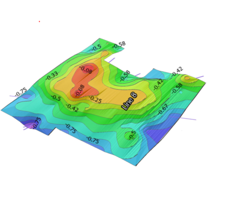
In 2023, 2-10 decided to take the program a step further and add 3D modeling capabilities to make tilt and deflection reports even more user-friendly for claims adjusters and claimants.
Argis used ArcGIS Pro SDK for .NET to build an add-in tool for ArcGIS Pro that creates a 3D model. The tool generates an elevation image built from a CSV file containing x,y coordinates and the coordinates’ elevations. Then, the user overlays the elevation image with a PNG file of the home’s foundation blueprint. The tool generates a three-dimensional side view that shows exaggerated terrain relief in different colors. Red indicates the highest elevation and purple indicates the lowest. The color-coded 3D view gives nonexperts a visual reference, helping them quickly understand the severity of a home’s tilt and deflection.

“The 3D view shows the shape of a home’s floor system. It adds another dimension to support understanding versus a flat two-dimensional model,” Vialpando said. “Claims adjusters aren’t engineers. They need to be able to interpret and explain this very nonstandard engineering task to claimants for claim resolution. We had to be able to translate a very high-level analysis into something that could be used and understood by nonexperts.”

