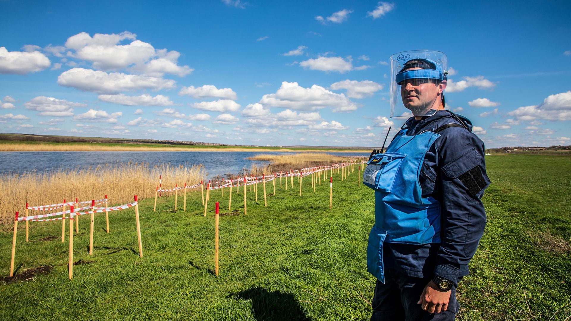
Removing the debris and rebuilding infrastructure is a tremendous challenge that is being faced by Ukraine. Hundreds of thousands of buildings and structures have been damaged or destroyed by Russian aggression. At the beginning of 2023, the country had accumulated as much as 100 million tons of debris from this devastation.
This destruction must be assessed and documented so that rebuilding efforts can be prioritized and coordinated. Assessing damage and coordinating rebuilding projects are supported by ONOVA GIS HUB, a geoinformation technological platform designed to quickly and comprehensively collect data related to specific objects, communities, regions, and sectors in Ukraine for documentation and analysis.
ONOVA, Ukraine’s Renovation League, is working with Ukrainian communities, state institutions, and relevant ministries; Ukrainian and foreign investors; international donors; representatives of national and international business contractors such as software developers and real estate developers, service and material suppliers; representatives of nongovernmental organizations (NGOs); independent expert associations; and media. The goal is to renew destroyed territory in Ukraine quickly and efficiently to modernize and make it stronger for future generations.
The Public Union Ukrainian Fund of Energy Efficiency and Energy Saving (PU UFEES) with Esri Ukraine LLC and ECOMM Co LLC, is working together to create the ONOVA GIS HUB as a tool to collect damage data and coordinate reconstruction efforts. PU UFEES supports initiatives to introduce incentives and measures to improve the energy efficiency of buildings as well as the implementation of modern European Union (EU) environmental safety standards in Ukraine. It initiated Ukraine’s Renovation League ONOVA. Esri Ukraine, an Esri distributor, provides a geographic information platform for creating a corporate GIS. ECOMM has decades of experience developing and implementing GIS in Ukraine.
An interactive online portal, ONOVA GIS HUB has public and private parts. Ukraine’s Renovation League ONOVA will use the private portion of ONOVA GIS HUB to:
- Enter, edit, and analyze the data it is contributing.
- Categorize damage by level and extent using photographs and surveys of public and private buildings.
- For each building, collect reports, expert opinions, restoration projects and their estimated cost, and current status of restoration.
- Choose data for maps.
- Choose data for dashboards.
Link infrastructure to a master development plan, land cadastre, and critical infrastructure networks like water systems, electrical grids, or gas pipelines.
The ONOVA GIS HUB has become an important tool for the digitalization of communities in the context of reconstruction. It has already been used by more than 50 communities in Ukraine, including Irpin, Bucha, Makariv, Chernihiv, Mykolaiv, Kharkiv, and Kremenchuk. These are areas that have been heavily damaged by Russian Federation attacks.
The platform is used to formulate national programs for the reconstruction and development of Ukraine by the heads and relevant structural units of the Ministry of Energy of Ukraine, the Ministry of Youth and Sports of Ukraine, the Ministry for Communities, Territories and Infrastructure Development of Ukraine, and the Ministry of Reintegration of the Temporarily Occupied Territories of Ukraine. Negotiations are underway with other government agencies.
Using the ONOVA GIS HUB, the Ministry of Youth and Sports has created the most accurate map of damaged sports facilities in all regions of Ukraine and introduced a mechanism for recording information about sports facilities and youth institutions that have been damaged or destroyed during the hostilities.
The development of the ONOVA GIS HUB project is actively continuing, including integration with Ukrainian and global information resources. The Ministry for Communities, Territories, and Infrastructure Development of Ukraine (Ministry of Recovery), as the main coordinator of the reconstruction process, signed a memorandum with the PU UFEES on the creation of the GIS of Infrastructure of Ukraine.
The ONOVA pilot project is currently being implemented in cooperation with the Recovery Agency (a structure of the Ministry of Recovery) in the settlements of Borodianka, Yahidne, and Posad-Pokrovske. Project proposals for the restoration, construction or reconstruction of individual facilities are being mapped on ONOVA GIS HUB.
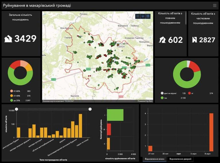
In total, the ONOVA GIS HUB database includes more than 25,000 objects that have been damaged. As an example, in a joint project with the Ministry for Communities, Territories, and Infrastructure Development of Ukraine and the Bucha territorial community, ONOVA GIS HUB capabilities are used to create plans for the development of social infrastructure institutions in the Bucha community. Thanks to the capabilities of ONOVA GIS HUB, an analysis is helping match the needs of the community with the available resources. The restoration of Bucha schools is planned, and school bus routes will be reestablished.
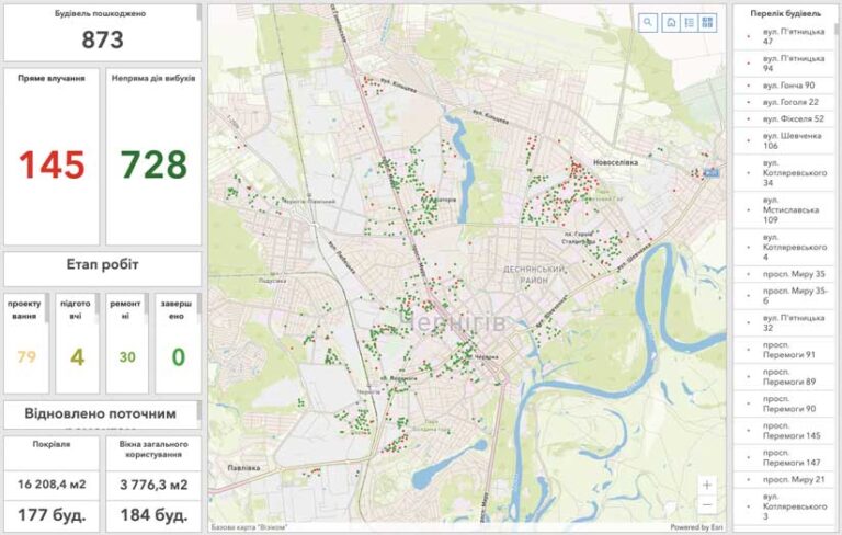
The ongoing development of the ONOVA GIS HUB includes integration with Ukrainian and global information resources. Ministry of Recovery, as the main coordinator of the reconstruction process, has signed a memorandum with the PU UFEES for the creation of the GIS of Infrastructure of Ukraine.
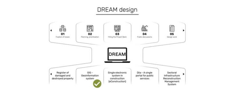
In addition, ONOVA GIS HUB is being integrated with DREAM, the state digital ecosystem. DREAM is an accountable recovery management system that collects, organizes, and publishes open data at all stages of recovery projects in real time. The ONOVA GIS HUB is becoming a transparent, extremely effective tool for assisting with the entire Ukrainian renewal process. The platform is already playing a key role in shaping new sustainable development strategies for an independent, European, and prosperous Ukraine.
In commenting on the activities of the executive bodies of the council regarding the ONOVA GIS HUB, Anatoliy Karbovsky, deputy head of the Makariv Community, noted “ONOVA GIS HUB has become an important project for the Makariv community in the context of rebuilding after the destructive actions caused by Russian aggression. Thanks to ONOVA GIS HUB, we have a useful tool for recording destruction [and] collecting and analyzing data on damaged buildings and infrastructure. This is important for further recovery and transparent investment attraction by our community. I hope that this is a significant step forward in the recovery and development of Ukraine, allowing us to collect, analyze, and use data for future planning. In peacetime, the geographic information portal can serve as a tool for analyzing and planning urban development, including master plans, financial information, and indicators of socioeconomic development.”
