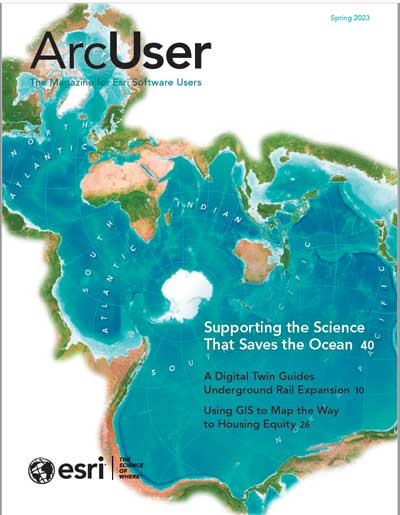
The map on the cover of this issue shows the Spilhaus World Ocean Map in a Square, a world projection that emphasizes the extent to which the ocean dominates the globe, covering more than 70 percent of its surface. This map also lets us see the ocean as it truly is—one continuous body of water that wraps around all Earth’s landforms.
Not only does the ocean dominate the Earth physically, but it is also a bulwark against climate and essential to the water cycle. In addition, the ocean helps feed the world and transport most of its goods. In short, the ocean is critical to the Earth’s fate.
In addition to visualization, GIS provides many ways to see the ocean in more depth. GIS is helping fulfill the goal of the United Nations Decade of Ocean Science for Sustainable Development (Ocean Decade) by moving from the ocean we have to the ocean we need for the future we want.
Esri is participating in several Ocean Decade programs that are developing science to better understand and preserve the ocean. In addition to its role in a project to map the entire seafloor, Esri, along with 40 global partners, is involved in Digital Twins of the Ocean (DITTO), a program to create digital twins of the ocean that will not only increase understanding of current conditions but model future states and measure the potential effectiveness of mitigation efforts using specialized tools and artificial intelligence (AI) capabilities. DITTO is working to make ocean data available to all nations to better inform decisions.
Digital twins—initially employed to optimize manufacturing processes and the management of utilities, airports, and even cities—are increasingly being used to understand and sustainably manage portions of the natural world. With its 3D visualization and data integration capabilities, GIS is foundational to the creation of digital twins.
More broadly, GIS is the technology for applying the geographic approach, marshalling and analyzing data, producing and disseminating information, and gaining a more holistic understanding of the ocean. We need to see that the ocean’s problems are the Earth’s problems—it’s all one interconnected, interdependent world.
About the author