Transportation and supply chain services provider Watco worked with geospatial IT services company and Esri partner GCS to move the company from spreadsheets to a spatially enabled process that helps its customers identify the best locations for railcar storage, transloading, and industrial properties.

Established in 1983, Watco operates throughout North America and Australia with an extensive network of short line railroads, terminals, ports, and railcar repair facilities. Their services cater to diverse transportation needs and offer solutions for various materials, commodities, and products across different markets.
Watco wanted a web-based solution that would help its customers find the locations with services and space for development that they needed. GCS collaborated with Watco in designing, developing, and implementing an intuitive geospatial web application that showcased Watco’s solutions to existing and perspective customers.
The goal was a site that would allow customers to easily navigate through Watco’s offerings via a map-based interface. Key priorities for the project included ensuring mobile compatibility, creating a unified resource hub for both prospective and existing customers, accommodating future enhancements, optimizing filter functionalities, and incorporating a customer-centric form for contacting Watco.
The effort involved converting legacy spreadsheets into spatial data features. The result was GeoConnect, an application built using ReactJS and the ArcGIS API for JavaScript 4.25 that seamlessly integrated with Watco’s existing WordPress website and infrastructure. GeoConnect’s three modules—Railcar Storage; Transloading; Material Handling & Storage; and Find Property—offer versatile functionality to customers. These modules provide Watco with a GIS-powered solution that is tailored to customers’ needs.
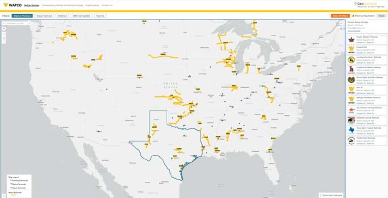
In late 2022, Watco launched GeoConnect with the Railcar Storage module, a tool designed to facilitate railcar storage searches. The Railcar Storage module employs search tools and filters to pinpoint locations that precisely match the customer’s railcar storage requirements. They use an interactive map to explore storage locations, perform address searches, or generate a comprehensive list of Watco sites that offer this service. Users can refine search criteria by state, Class I railroad affiliation, distance to city, track capacity, and hazmat suitability. Detailed information, such as railcar capacity and Class I interchanges, is available for individual locations.

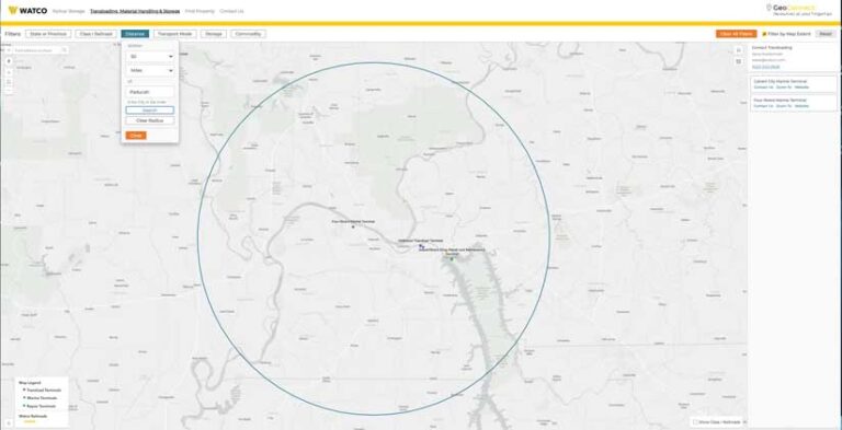
Watco expanded GeoConnect in spring 2023 to include the Transloading, Material Handling & Storage module. This module assists customers in identifying sites based on factors such as customer location, preferred transportation mode, and storage specifications. Customers can use a map with filtering options to explore available transport modes, Class I railroad connectivity, storage capacities, and other pertinent location details.

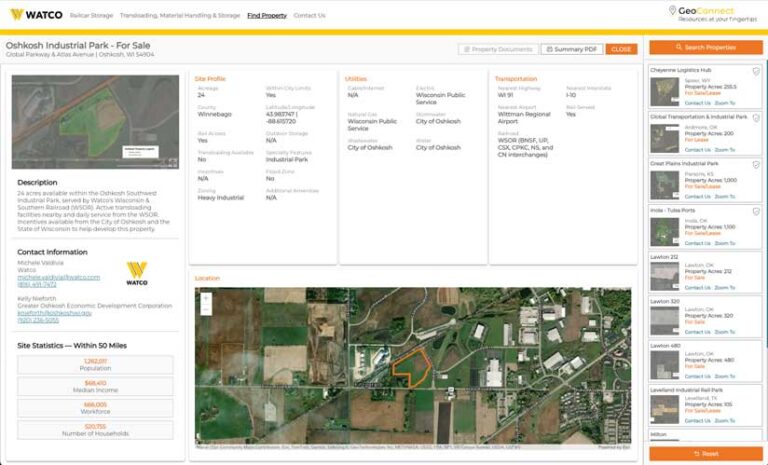
The Find Property module was added to GeoConnect in early 2024. This module empowers customers to discover sites for business development that are owned or operated by Watco. Buildings and sites for development can be located using extensive search criteria and interactive maps with informative pop-ups. Property detail pages summarize property offerings and include associated images, documents, and area statistics.
Watco key services are seamlessly integrated into a user-friendly online platform hosted by ArcGIS Online. Watco uses an air-gapped system to ensure secure data management. GeoConnect data is curated by staff in the ArcGIS Enterprise environment. The data flagged for publishing is synced to the public-facing ArcGIS Online organization and visible on GeoConnect. This hosted-copy pattern ensures that customers can interact with up-to-date data, staff can continue to manage the data in their enterprise system, and Watco’s internal GIS is not exposed to the public.
This fully customized application is meticulously tailored to meet the precise requirements outlined by Watco to benefit its customers. It serves as a prime example of workflow streamlined with ArcGIS technologies. The GCS solution empowers potential Watco customers by offering ArcGIS-enabled tools that unlock the spatial potential of Watco’s data. GeoConnect has transformed Watco’s data into actionable information for its customers.
The project team of GCS staff members that created this solution was led by GIS analyst Jay Egenhoff. The other project team members were Cass Kalinski, senior GIS analyst; John McIntosh, senior software architect; Peter Puczkowskyj, software developer; Ryan Greene, software developer; Seth Bettwieser, software developer; and Rachel Bryant, GIS analyst.
“GeoConnect has revolutionized the way customers explore railcar storage and transload solutions at Watco. In a crowded marketplace, GeoConnect stands out, offering potential and existing customers an intuitive way to identify premier sites, railcar storage locations, and transload options,” said Aaron Baumgarden, manager of GIS programs at Watco.
Watco first learned about GCS during a presentation by GCS staff at a GIS for Railroads workshop. GCS is a leading provider of geospatial information technology services to a wide array of industry sectors and specializes in crafting GIS solutions that effectively convey geographic insight to its clients and optimize workflows. Watco entrusted the entire application life cycle to GCS, which continues providing ongoing enhancements and support for the solutions.
Explore GeoConnect at www.watco.com/geoconnect. For more information, please contact Seth Johnston.


