What should a large city government do when it learns that mission-critical software used in more than 30 departments by more than 1,000 employees is going to be retired?
That was the question facing Austin, Texas, in March 2019 when Esri announced that ArcMap, part of ArcGIS Desktop, would be retired. (The retirement date is currently March 2026.)
The eleventh-largest US city, and home to the influential South by Southwest Conference, Austin has a strong reputation for technology innovation and collaboration. The city decided to begin the transition from ArcMap right away.
“The general thinking was, ‘We’re going to have to move to ArcGIS Pro, so why put it off?,’” said Shanon Sims, IT project manager in the Enterprise Geospatial Services division of Austin’s Communications and Technology Management (CTM) department.
Austin launched its citywide, three-phase GIS Modernization Project to minimize future disruption and leverage new ArcGIS capabilities to create a more collaborative data-sharing environment. The primary project goal is to migrate all GIS users from ArcMap by March 2023. The project also includes upgrading GIS servers and enterprise geodatabases to ArcGIS Enterprise.
Austin’s Geospatial Information Management Governing Board and CTM are guiding the effort. Each participating department has an executive sponsor and a GIS single point of contact, or SPOC. Despite the project’s large scale, it does not use a one-size-fits-all approach. Each department has unique needs and oversight on its portion of the migration.
“It’s a flexible plan,” said Sims.
Planning Gets Under Way
As an Advantage Program member, Austin has access to Esri Services experts on all aspects of complex GIS implementations—technical and human. When the GIS Modernization Project began, department sponsors completed a series of implementation assessments.
One assessment revealed that, due in part to the number of individuals and departments impacted, some GIS users may not immediately embrace migration-related changes. When individuals are ambivalent about—or even resistant to— changes impacting their daily work, the risks of slower rates of technology adoption and delayed project milestones increase.
Austin’s proactive approach to migration is intended to reap the business benefits of modern GIS infrastructure more quickly. Aligning technical goals with people-focused goals was a logical step to drive project success. Esri consultant Michael Green was engaged to conduct people-focused change management activities.
“The people side of the modernization project is just as important as making sure the technical solutions are solid,” said Green.
Six city departments participated in phase 1 of the project, which included change management. Green led the department sponsors and stakeholders through a Preparing for Change workshop, in which participants documented the strategic business outcomes that their departments would achieve from the technology project.
Those business outcomes would be translated into key messaging points and embedded into detailed change management and communications plans for each department.
Putting a People Plan into Action
The GIS Modernization Project charter states that 100 percent of Austin’s ArcMap users will be provided with a modern GIS solution. Before the team could determine the right GIS solution for each ArcMap user, they had to identify all GIS workflows, applications, and software versions in use citywide.
The number of ArcMap users was originally thought to be 1,200, but later, through ArcGIS License Manager data and installation lists, the team found that the actual number was about 1,400. To determine the right solution for each ArcMap user, CTM examined ArcMap license usage data to ascertain the user activity level in each department.
“We had to define power users versus light users and all the variations across the spectrum,” said Sims. The team decided that power users (those performing geospatial analysis and advanced workflows) would migrate to ArcGIS Pro, and light users (those primarily using ArcMap for visualization) would switch to ArcGIS Online.
The Importance of Training
With a clear migration path for each ArcMap user, it became imperative to provide individuals with the support they would need to be productive with their new GIS solution.
“We have an overarching plan to migrate all City of Austin GIS users, but department by department, that looks different,” said Sims. “As we looked at the initial needs, we realized that training was a huge part of the change management and of the migration effort.”
In fact, training is a key component of every people-focused change management plan. Supporting individuals with resources tailored to their needs is an effective way to build trust and confidence that change is achievable.
Esri training consultant Tamara Adamson works with Sims on course recommendations and training plans. EAP credits were allocated for GIS users to attend instructor-led classes, and Esri e-Learning resources are heavily used.
Adamson is impressed with Austin’s commitment and detailed approach to training. “The city is ahead of the curve,” she said. “They’ve gotten very specific in identifying people who need instructor-led training and those who need e-Learning. They’ve been very purposeful about it.”
Adamson shares training usage reports with Sims and assists with customized learning plans that managers can assign to individuals through Esri Academy (www.esri.com/training/) and then monitor their progress. Learning plans can include instructor-led or self-paced resources or both. In addition to classes, videos, web courses, and tutorials, technical documents, like the ArcGIS Terminology Guide, are available.
As the migration progresses, SPOCs work directly with individuals to help them identify best-fit course paths based on their ArcMap and ArcGIS experience and the GIS workflows they perform.
“We didn’t start off knowing what these paths are and how we could organize the resources this concisely,” Sims said. “It’s been a work in progress to get to this point,” she continued.
“With remote work situations due to COVID-19 restrictions, Esri’s e-Learning and instructor-led online classroom have provided the just-in-time training needed to help everyone effectively and efficiently migrate,” said Sims.
While not mandated, training is strongly encouraged. Sims frequently discusses training resources in project team and governing board meetings, and they are featured prominently in her user communications.

Staying on Course with Creative Communications
From the outset, Green emphasized the importance of communication. Effective change management requires continual attention to building awareness that change is coming and sharing information on project progress and its benefits to the organization and to each impacted individual. For Sims, communication is a top priority.
The city’s EAP credits enabled her to continue working with Green on a biweekly basis in phase 2.
Communication is a frequent topic in their discussions.
“Michael has been really integral in helping me develop language, key messaging points, and how we approach training,” said Sims.
She leverages data to communicate the project’s current state. Sims created a report for each department that shows monthly ArcMap and ArcGIS installation and license usage for its users.
The report is color coded, which makes it easy to visualize how ArcGIS use is growing within each department over time or, in some cases, lagging behind expectations. When managers see that an individual is still mostly using ArcMap after receiving ArcGIS migration support, they reach out to that person to discuss training resources and reinforce the benefits of migrating to ArcGIS Pro.
Sims also creates visually engaging presentations, flyers, infographics, and dashboards to communicate with project stakeholders and GIS users. She sends a monthly newsletter to all employees who have ArcGIS on their device. Communication topics include project updates, training resources, and interesting new information products that have been created.
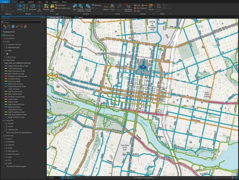
One example is the 2021 edition of the Austin Bike Map. Previously, staff used ArcMap to create the map, then exported simple line work to Adobe Illustrator, where the bike routes were stylized and placed on top of the city’s basemap. That workflow sometimes created discrepancies between the map and the GIS database.
“If new bike routes came online during the styling process, they would be added in Illustrator, but sometimes the updates would be missing in the GIS,” said Alan De Anda, senior geospatial analyst in the Austin Transportation Department’s Data and Technology Services group.
“The basemap data could also get stale, which can happen very quickly in a city as rapidly growing as Austin,” De Anda continued. “Now, all our geographic layers are maintained and stylized in ArcGIS Pro, and only exported to Adobe Illustrator to mix with the infographic art.”
All communications are designed to reinforce awareness of the migration and answer questions that GIS users may think but not verbalize, such as Why are we doing this? and What’s in it for me?
“One aspect that’s really added value to the communication from a change perspective is that Shanon integrated change management activities directly into her project plan,” said Green. “She’s operating from one plan, not two, which streamlines execution and serves her well.”
A Sustainable GIS for the Future
The final group of departments will soon begin their migration. The city is well positioned to meet its self-imposed deadline of March 2023.
Sims, who started her job with CTM just five weeks before the COVID-19 pandemic forced employees to work from home, is pleased with the city’s unified approach to building a sustainable, modern GIS infrastructure. But as important as the technology is, she most values the people side of the project.
“I had a very small window to meet my team and learn the ins and outs of city government operations. Their support has been tremendous. I could not ask for a better group of people to work with.”
For more information on the City of Austin’s GIS modernization initiative, contact Sims at Shanon.Sims@AustinTexas.gov.


