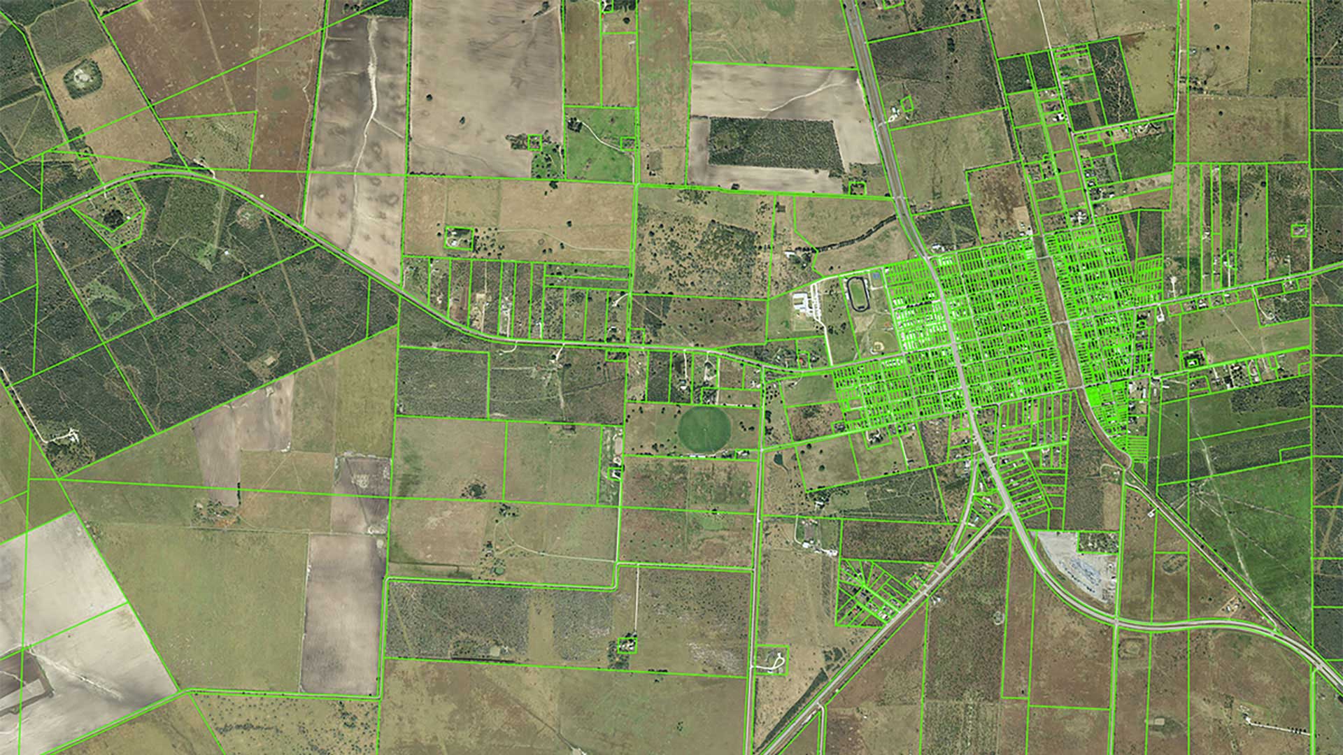
Jack Chen is a GIS developer in the Geospatial Information Services (GIS) division of the Mecklenburg County Land Use and Environmental Services Agency in North Carolina. He was tasked with migrating the county’s ArcMap parcel fabric from to ArcGIS Pro parcel fabric and performing data verification. This article, describing how he accomplished the migration, will be helpful to GIS managers in other counties who plan to migrate to a newer parcel fabric version. It will also benefit GIS administrators, analysts, and developers who might participate in the migration and are familiar with SQL.
Mecklenburg County, North Carolina, had been using the ArcMap parcel fabric since October 2019. In July 2023, the goal of migrating the county’s parcel fabric from ArcMap to ArcGIS Pro was set. The migration was one of the first steps that would let the county take full advantage of ArcGIS Enterprise for different data-driven enterprise applications to support the county’s business activities.
Just a year later, Mecklenburg County’s parcel fabric had been migrated from ArcMap to ArcGIS Pro. Immediately following the migration, data verification was carried out via a SQL script to confirm that parcel fabric migration was successful. Migration allowed the county’s GIS division to continue providing high-quality parcel data and facilitate the use of ArcGIS Pro and ArcGIS Enterprise.

Preparing for Parcel Fabric Migration
Before beginning the migration process, Chen studied online Esri documentation for the data models for both ArcMap and ArcGIS Pro parcel fabric. By September 2023, he had conducted several tests using the Upgrade ArcMap Parcel Fabric geoprocessing tool to upgrade a sample ArcMap parcel fabric to an ArcGIS Pro parcel fabric in a file geodatabase.
After completing two other GIS projects, Chen refocused his work on the parcel fabric migration from March to June 2024. On June 6, 2024, both the county’s testing and production ArcGIS Enterprise implementations were up and running. These included all the ArcGIS Enterprise components including Portal for ArcGIS, ArcGIS Server, and ArcGIS Data Store.
To complement both the testing and production in ArcGIS Enterprise, he worked with a database administrator from the county’s IT department to create a testing enterprise geodatabase and a production enterprise geodatabase on two different remote SQL Server database servers. Chen refined his workflow using ArcGIS Enterprise and a testing enterprise geodatabase. Emma Rosenthal from Esri also provided technical support for this process.
Processing the parcel fabric locally fully utilized Chen’s powerful workstation computer. It took eight hours to complete the workflow. In the final step of this workflow, he copied the ArcGIS Pro parcel fabric from a file geodatabase on his workstation to the testing enterprise geodatabase on the remote SQL Server.
Preparing for Data Verification
When Chen was preparing for the migration, he was asked how to determine if the parcel fabric migration was successful. To verify migration success, he needed to answer three questions:
- How many plans, points, lines, and parcels were migrated from the ArcMap parcel fabric to the ArcGIS Pro parcel fabric?
- If all elements did not migrate, which ones did not migrate and why?
- Did the plans, points, lines, and parcels that were migrated keep their original geometry and attribute values?
While ArcGIS Pro might be used to manually compare plans and records, points, lines, and polygons before and after migration, that approach is not practical when checking millions of features.
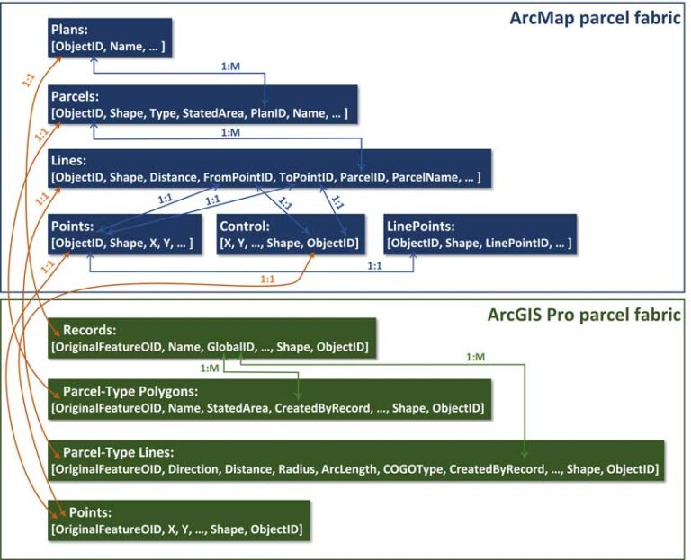
While the Spatially Enabled DataFrame in ArcGIS API for Python could be used to verify data, Chen believed that SQL was a more efficient way to verify not only the number of objects migrated, but also their geometry and attributes. First, he illustrated the relationships among tables. Then, he copied both the ArcMap and ArcGIS Pro parcel fabric from an experimental test of parcel fabric migration conducted in June 2024. He put the ArcMap parcel fabric into a database schema called aq, and the ArcGIS Pro parcel fabric to another database schema called lr. Both database schemas were located in the same testing enterprise geodatabase in the remote SQL Server.
With both the ArcMap and ArcGIS Pro parcel fabric in the same testing enterprise geodatabase, Chen wrote SQL statements to compare the plans, points, lines, and polygons in ArcMap parcel fabric to their counterparts in ArcGIS Pro parcel fabric. Running SQL statements enabled him to perform data analysis and validate the success of the migration.
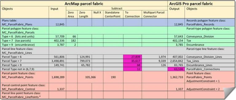
It took two weeks for Chen to complete the SQL script. After answering specific questions about the migration with this table, he expected that the parcel fabric migration would be successful.
Chen’s scripts validated the parcel migration. Running three different portions of the SQL statements shown in Listing 1 in Microsoft SQL Server Management Studio returned:
402,336 parcels (the number of tax parcels in ArcMap parcel fabric)
402,154 parcels (the number of tax parcels in ArcGIS Pro parcel fabric)
402,154 parcels (the number of tax parcels migrated)

The difference between the number of ArcMap and ArcGIS Pro parcels was 182. Why didn’t these parcels migrate? He ran the SQL statement shown in Listing 2 and found that all 182 tax parcel polygons had zero area and perimeter length so that they did not migrate.
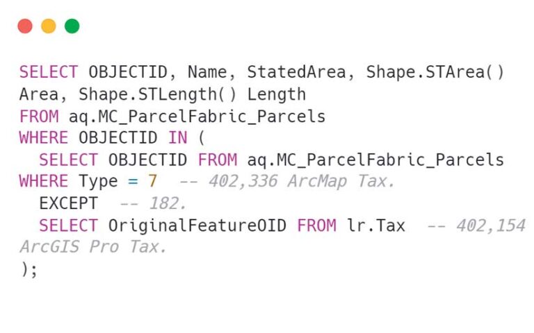
Next, Chen ran the SQL statement in Listing 3 to find out if—after migration—all parcel polygons kept their original geometry and attribute values. No parcels were returned, which showed him that after migration the parcel polygons’ original geometry and attribute values were preserved.

Implementation
After thoroughly testing the parcel fabric migration and data verification workflow in the testing environment, Chen used the same workflow to complete the county’s parcel fabric migration in the production environment in a single day, July 27, 2024. The production environment consisted of the production ArcGIS Enterprise and the production enterprise geodatabase. The next day, Chen ran his SQL script and summarized the data verification in a table that proved that the county’s parcel fabric migration was a success.
Editing ArcGIS Pro Parcel Fabric Data in ArcGIS Enterprise
During his experiments in the testing environment in early June 2024, Chen created a map for staff in the county’s Land Records Agency to use when editing parcel fabric data in ArcGIS Pro. He first published the ArcGIS Pro parcel fabric in the testing enterprise geodatabase as a web feature layer. Then he worked with the land records staff to design the map with the web feature layer and other supplementary layers.
Chen wrote an ArcGIS Arcade script to create attribute rules for the critical fields in ArcGIS Pro parcel fabric feature classes. He also modified an Arcade script provided by Esri to intelligently label the length values of parcel-type line features in the ArcGIS Pro parcel fabric’s web feature layer. He intended to let the land records staff use the map to get familiar with ArcGIS Pro and its record-driven editing style as early as possible.
Meanwhile, the county’s GIS department had the land records staff take Esri training classes on ArcGIS Pro and the parcel fabric. This training would help them avoid a transition shock when they began editing the parcel fabric in ArcGIS Pro in the production environment.
After successfully migrating the parcel fabric, Chen published the ArcGIS Pro parcel fabric in the production enterprise geodatabase as a web feature layer to the production ArcGIS Enterprise portal. Then, he copied the map which he previously created for the testing environment, changed the data source of ArcGIS Pro parcel fabric’s web feature layer from the testing ArcGIS Enterprise portal to the production ArcGIS Enterprise portal. Finally, he gave the updated map to the land records staff. This ensured a seamless transition from ArcMap to ArcGIS Pro. They were instantly using ArcGIS Pro and the map to edit ArcGIS Pro parcel fabric in the production environment, beginning on July 28, 2024.
Support for Parcel Migration Efforts
It took Chen five months to complete the parcel migration. To help others still using the ArcMap parcel fabric migrate to the ArcGIS Pro parcel fabric, he detailed his parcel fabric migration process in a Microsoft Word document and made ArcMap and ArcGIS Pro parcel fabric data in two file geodatabases, and his SQL script in two text files available at https://tinyurl.com/mrxhuma3.
The folder contains a ReadMe.txt file describing how to use the data and SQL script. His SQL script worked for an enterprise geodatabase in SQL Server 2016 or newer version. With minimal modification in SQL spatial data type methods that would entail changing from Shape.STArea() for SQL Server to ST_Area(shape) for PostgreSQL with PostGIS and Oracle, his SQL script should work for an enterprise geodatabase in PostgreSQL with PostGIS or Oracle.


