Maps have a profound association with warfare. Historically, numerous cartographic agencies were integrated with their countries’ military organizations. The same was true for the Japanese agency that produced many maps outside Japan’s borders for military operations and colonial administration before the end of World War II. These maps were referred to as Gaihozu, meaning “maps of outer lands.”
Apart from their original purpose, these Gaihozu maps now stand as invaluable scientific records showing the previous condition of land in various parts of the Asia-Pacific region. Currently, advancements in satellite observation technology permit the capture of detailed landscape changes over a wide area. However, understanding historical land use and vegetation in the Asia-Pacific region prior to the advent of satellite technology remains challenging.
What did Shanghai look like a century ago? Currently, Shanghai has a population of 20 million, which makes it one of the largest cities in the world. The area that is today the city of Shanghai was formerly known as the Shanghai International Settlement, as indicated by the Gaihozu maps.
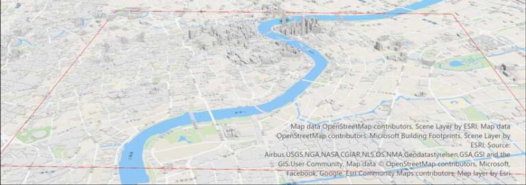
With the construction of many skyscrapers, the urban area of Shanghai has undergone significant change since the 1930s. A Gaihozu map from 1932 shows of the urban area of Shanghai and its surroundings extending to the mouth of the Yangtze River in Shanghai in 1932. A current 3D topographic basemap of the same area of Shanghai shows that rural villages have disappeared and the road layout has substantially changed.
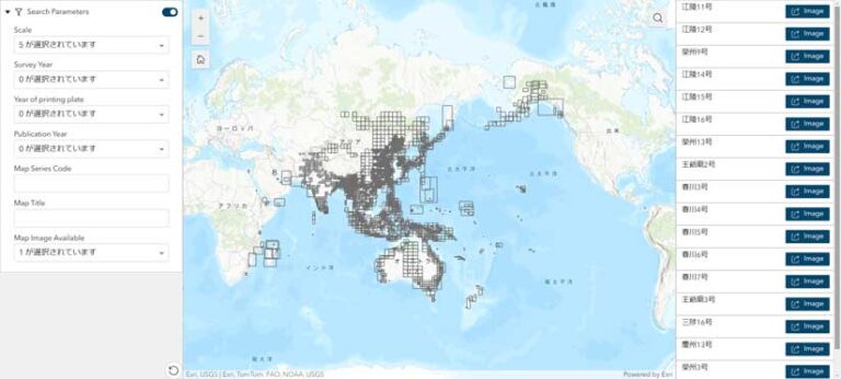
The geographical coverage of the entire Gaihozu collection at Tohoku University encompasses a vast area that extends north to Alaska, east to the United States mainland and the Isthmus of Panama, south to Australia, and west to Pakistan and Afghanistan as well as the eastern parts of the African continent.
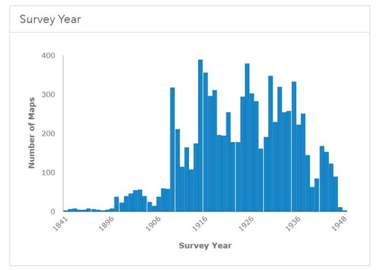
These maps were surveyed between 1886 and 1945. The Gaihozu collection, which is currently housed at Tohoku University, comprises more than 10,000 maps, making it one of the largest collections of 19- and 20-century Japanese maps and a highly valuable resource for the study of landscapes in the Asia-Pacific region during that era.
At the conclusion of World War II, when the Japanese military was disarmed, the Gaihozu maps were scheduled for incineration. However, Japanese geographers, recognizing the scientific value of the maps, intervened and successfully rescued them. Approximately 100,000 Gaihozu maps, including numerous duplicates, were packed into a single freight car and transported to Tohoku University in Sendai City, a major northeastern regional city in Japan, amidst the chaos at the end of the war.
In the late 1990s, geographers at Tohoku University began cataloging the Gaihozu collection. The catalog was used as a map metadata source in the creation of digital archives of maps. In the 2000s, the digital maps were created by scanning the paper maps.
Tohoku University has made the Gaihozu Digital Archives available to the public since the 2000s to increase awareness of their existence and contribute to research and education. The archives were designed as a web-based system for the display of Gaihozu map images and has been utilized by numerous researchers.
[An article about this web app, “Finding Lost Landscapes in Southeast Asia,” appeared in the Fall 2020 issue of ArcUser (links.esri.com/prevapp).]
However, in 2022, this public access system became unavailable due to aging servers and issues with system management. In October 2023, the project team responsible for renewing the Gaihozu digital archives launched a new initiative to make these maps publicly accessible using cloud technology, which would minimize hardware maintenance costs.
Ultimately, the renewed Gaihozu Digital Archives were released in January 2024 using ArcGIS Online. The archives currently contain more than 10,000 images stored at Tohoku University, with both English (gaihozu-tohokugeo.hub.arcgis.com/) and Japanese (gaihozu-jp-tohokugeo.hub.arcgis.com/) sites now available.
The digital archives include web applications for searching and viewing Gaihozu images, brief narratives for selected maps, and comprehensive background explanations of the Gaihozu collection. ArcGIS Hub enables the incorporation of diverse digital content, such as web applications, images, texts, and graphs. Multiple individuals can collaborate and edit the sites. ArcGIS Hub was instrumental in the sites’ efficient development. The websites function optimally on both desktop and mobile devices.
Two web applications let users search for Gaihozu images. One application provides a mapcentric experience based on map location and extent. Given the extensive geographical coverage of these maps, search capability using the index map is crucial.
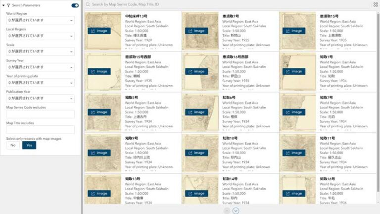
The other application enables users to search by map metadata items, including region name, scale, print year, and map title. Users can view the Gaihozu map image and its metadata by clicking the button on the web application.
The project team used ArcGIS Experience Builder, which expedited building applications to provide both search methods. A comma-separated value (CSV) file containing the entire database can be readily exported from the web application for subsequent analyses.
Gaihozu maps left behind after World War II have been scattered around the world, which resulted in an incomplete historical record. Many Gaihozu maps were confiscated by the Allied Forces and are now stored at various institutions in the United States. Many maps have been left in storerooms for extended periods. Recently, Stanford University Libraries and other institutions made their collections available to the public after cataloging them.
The establishment of a similar web-based system for Gaihozu, including the Gaihozu Digital Archives, and sharing the basic database structure of map images and metadata may facilitate collaboration between dispersed archives through web services. These efforts can contribute to a more comprehensive understanding of Gaihozu maps and—through them—the past vegetation and land use in the Asia-Pacific region during the late 19th and early 20th centuries in greater detail than was previously possible.
Dr. Shigeru Kobayashi, a professor emeritus at Osaka University and an authority on Gaihozu studies, posits that the Gaihozu collection at Tohoku University is among “the most significant materials for the research and education of modern environmental change in East Asia and the western Pacific.“
The map images in this collection provide a detailed account of the historical landscape of the region and reveal changes that have occurred over time. GIS allows for systematic spatiotemporally positioning them and the mapping and analysis of changes detected.
For more information on this collection, contact the project team of Gaihozu Digital Archives at gaihozu-digital-archives@googlegroups.com.
